Fast-moving McKinney Fire blows up in western Siskiyou County; evacuations ordered
This story is provided free of charge as a public service to our communities. Please support local journalism and subscribe.
Erratic winds from thunderstorms fanned the McKinney Fire that's burning in western Siskiyou County, causing the blaze to grow to more than 30,000 acres in 24 hours.
The blaze in the Klamath National Forest started about 2:15 p.m. Friday and there was zero containment as of mid-afternoon Saturday.
Brush, tall grass and trees were on fire in the Oak Knoll Ranger District of the forest, where the fire started west of the Walker Creek Bridge on the south side of the Klamath River. The flames had jumped Highway 96 as air attack planes flew overhead.
Firefighters were getting help Saturday from two very large air tankers and two other smaller air tankers.
Live: McKinney Fire over 30,000 acres; evacuation orders, warnings expand west of Yreka
Highway 96 was closed from Highway 263, about 2 miles west of Interstate 5, to Scott River Road. The Siskiyou County Sheriff's Office was posting updates on its Facebook page telling residents to evacuate from the fire zone.
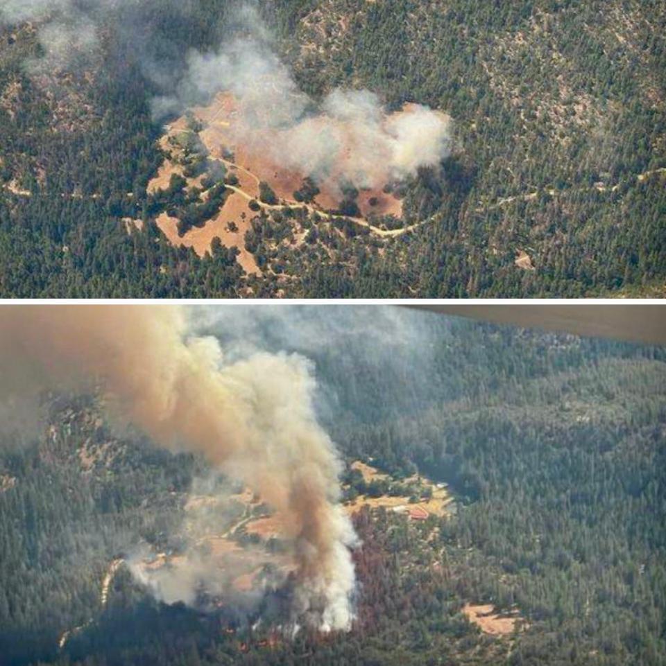
Klamath National Forest spokeswoman Caroline Quintanilla said the fire was estimated at between 30,000 to 40,000 acres on Saturday afternoon.
"We had a lot of lightning strikes Friday night and not very much precipitation and that's part of what has been driving this fire," she said.
Quintanilla said conditions were changing so rapidly that she didn't have an accurate map of the fire's boundaries.
"At this point, I don't have a perimeter map because with the erratic winds, there's not any specific direction it's moving in," Quintanilla said. "It's all over the map. Things have not settled down in a discernible pattern."
She arrived at the Forest Service headquarters before 7 a.m. Saturday to see a giant plume of smoke to the west, a dramatic sight that everyone else in town saw too.
Meteorologist Misty Firmin of the National Weather Service in Medford, Ore., said the McKinney Fire created a pyrocumulus cloud Friday.
"I've had varying reports. One of my co-workers said it was 39,000 feet. Another one said it was 45,000 feet," Firmin said.
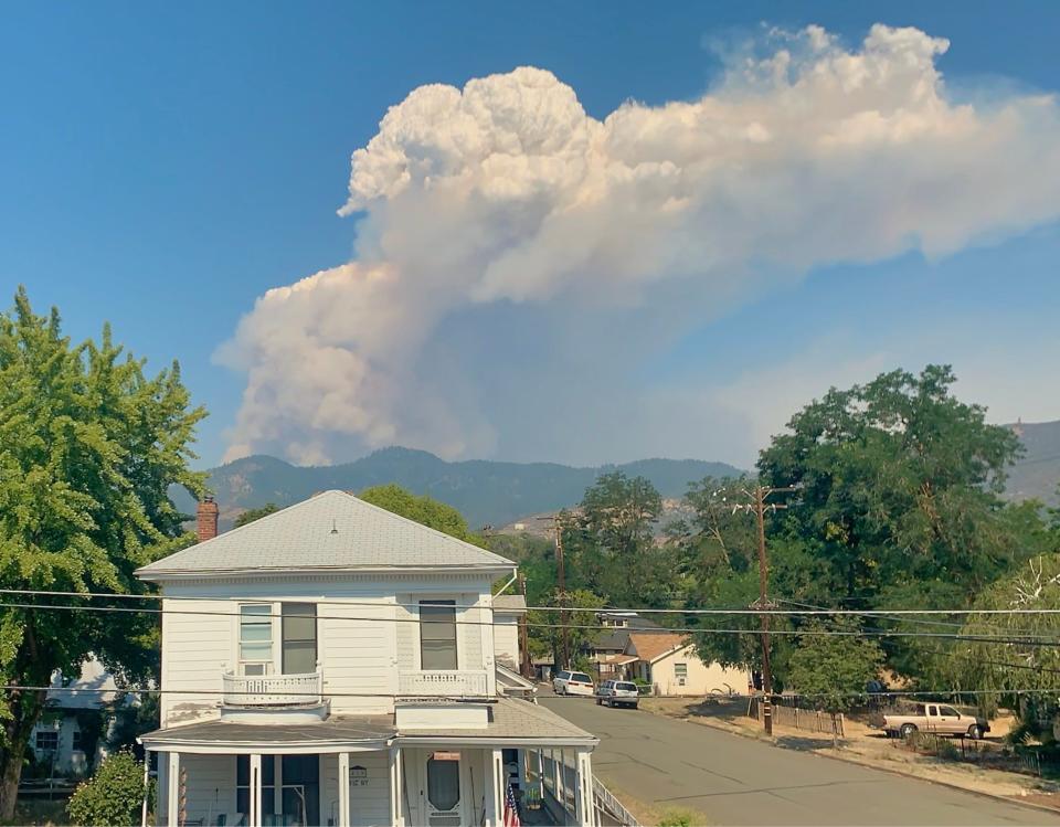
She said pyrocumulus clouds form in a similar way that thunderheads develop.
"If a fire is burning hot enough and strong enough, it can kind of create its own atmosphere. It gets so hot where it creates its own cloud and the cloud grows and turns into a pyrocumulus," she said.
Quintanilla said heat signatures were detected in the plume from infrared, thermal imaging.
Fire crews were dealing with very hot temperatures as a Red Flag Warning was in effect for lightning, fire officials said.
On Friday night, firefighters reported smoke coming from the Klamath River Post Office and trees down across the road near Walker Bridge.
People on social media described a fire tornado occurred around midnight in the area of the fire.
Firefighters were putting a priority on the evacuation of residents and making sure everyone was OK.
"We're not even working on containment at this point. We're working on catching up to the fire and getting people evacuated and making sure that everybody is safe," she said from the U.S. Forest Service office in Yreka.
The McKinney Fire wasn't the firefighters' only worry. The China2 Fire and the Evans Fire also started Friday and they had burned together by Saturday for an estimated size of 300 to 350 acres, forest officials said. That blaze was 2 to 3 miles west of Seiad.
"Resources are limited, however, because the majority of available personnel are aggressively working to slow the fast-moving McKinney Fire," fire officials said.
Winds from late-evening thunderstorms caused the McKinney Fire to grow significantly from Friday night to Saturday morning. The blaze was about 18,000 acres Saturday morning before it grew even bigger.
At 1:30 p.m. Saturday, a firefighter reported to fire managers on his radio that a 35-mph wind was gusting from the southwest accompanied by rain.
Deputies were busy Saturday going door-to-door in affected areas, telling residents to evacuate. Western Siskiyou County residents can go to zonehaven.com and type in their address to see what evacuation zone they're in.
As of late Saturday morning, the McKinney Fire was about 12 mies west of Yreka. At that time, evacuation warnings were in place for areas west of Yreka with one zone stretching across Interstate 5 north of the city.
A California Incident Management Team was in Yreka on Saturday for briefings and will assume control on Sunday morning, officials said.
Meanwhile, the Pacific Crest Trail Association was telling hikers in western Siskiyou County on Saturday to evacuate to the nearest town.
"The weather conditions, including lots of lightning, are leading to extreme fire behavior and dangerous conditions," the association said on its website.
The group was spreading the word that the Forest Service had closed a 110-mile section of the Pacific Crest Trail from the Etna Summit to the Mt. Ashland Campground in southern Oregon.
Mike Chapman is an award-winning reporter and photographer for the Record Searchlight in Redding, Calif. His newspaper career spans Yreka and Eureka in Northern California and Bellingham, Wash. Support local journalism by subscribing today.
This article originally appeared on Redding Record Searchlight: McKinney Fire blows up in western Siskiyou County; evacuations ordered

