Fast-moving snow squalls to threaten travelers in parts of Northeast
An Arctic cold front ushering in dangerous and record-challenging cold to the Northeast will also pose a second threat to some parts of the region into Thursday night.
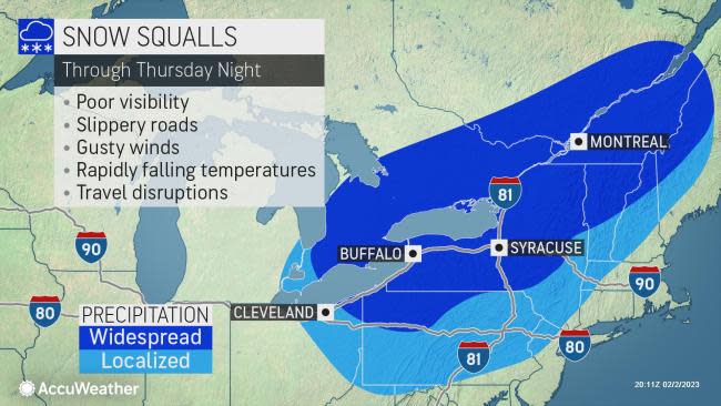
AccuWeather meteorologists warn that snow squalls can bring quickly accumulating snow that could result in whiteout conditions and cause travel disruptions from southern Ontario, Canada, into interior portions of the Northeast as the bitter cold arrives.
 |
Snow squalls are a wintertime relative of thunderstorms, bringing the potential for heavy snow and gusty winds, which can send visibility levels to near zero. Snow and ice can also coat roads quickly, adding to the danger. In the past, similar snow squall activity has contributed to serious injuries and even fatalities due to large pileups on area highways.
"The most intense snow squalls to move through the region may occur along the Arctic front itself, similar to a line of thunderstorms along a cold front in warmer months," said AccuWeather Senior Meteorologist Dan Pydynowski. "This band of intense snow along the front could stretch for hundreds of miles, spanning from the St. Lawrence River Valley through southern Ontario by Thursday evening, pushing southeastward across parts of New York, Pennsylvania and New England Thursday night."
 |
Cities including London, Toronto and Ottawa, Ontario, could receive intense snow just in time for the evening rush hour. Travelers out later in the evening in places like Quebec City and Montreal as well as parts of New York state such as Syracuse, Rochester and Buffalo will have to watch for sudden whiteout conditions and slippery travel.
"Much of the intense snow along this front will also occur after dark, which will also heighten the risk of whiteout conditions," Pydynowski said.
As the front advances farther south and east, conditions will become less favorable for heavy snow, and squalls will become more isolated before eventually dissipating completely. Mainly leftover flurries or a snow shower are all that is expected to accompany the bitter cold arriving in cities like Boston, New York City and Philadelphia along the Interstate 95 corridor by Friday morning.
 |
However, farther north and west, following the snow squalls along the Arctic front, the threat of additional lake-effect snow squalls will persist into Friday.
"Lake-effect snow squalls setting up from late Thursday night into Friday downwind of the Great Lakes will be more localized in nature but can still bring dangerous conditions with rapid changes in visibility and road conditions," Pydynowski explained. Several inches of snow could pile up in some spots where the lake-effect snow is most persistent.
 |
Gusty winds will also develop on Friday and continue into Friday night. The winds will create areas of blowing snow that can keep roads and sidewalks slippery even in areas that aren't getting snow at the time.
"With a combination of bitter cold and potential slippery travel, anyone traveling through these areas will want to make sure they are prepared for the worst, with plenty of warm clothes and supplies available in their cars should an accident occur or they become stranded," Pydynowski said.
Want next-level safety, ad-free? Unlock advanced, hyperlocal severe weather alerts when you subscribe to Premium+ on the AccuWeather app. AccuWeather Alerts™ are prompted by our expert meteorologists who monitor and analyze dangerous weather risks 24/7 to keep you and your family safer.


