Multi-day severe weather threat ahead for parts of the Prairies
With rain bringing sorely needed relief to quell the wildfires raging in parts of Western Canada, attention turns to the thunderstorm risk in other sections of the region this week.
Thunderstorms have peppered much of Western Canada for the last couple days, but a more favourable setup for severe thunderstorms on multiple days looks to be taking shape for mid- to late-week across the southern Prairies, primarily focused on southern Saskatchewan and southern Manitoba.
Visit The Weather Network's wildfire hub to keep up with the latest on the active start to wildfire season across Western Canada.
An upper-level low spinning over the Pacific Northwest will eject surface lows into southern Saskatchewan and Manitoba this week, triggering a widespread chance of storms for a few days. The potential is there for multiple rounds of severe weather for some areas.

Wednesday
Areas: A widespread thunderstorm threat will target southern Saskatchewan, with the threat for severe thunderstorms developing in the extreme south
Timing: Afternoon and evening
RELATED: Safety tips to avoid a lightning strike during a thunderstorm

Weather: Scattered rain showers and thunderstorms will track across southwestern Saskatchewan through the morning and afternoon. As daytime heating builds into the afternoon and the low-pressure system advances north, the atmosphere will likely help fuel stronger storm development into the early evening. Some of these storms will possibly track towards Regina.
The main threats with these storms will be heavy rain, strong wind gusts and the potential for hail. A supercell or two is also possible, with a low risk of an isolated tornado.
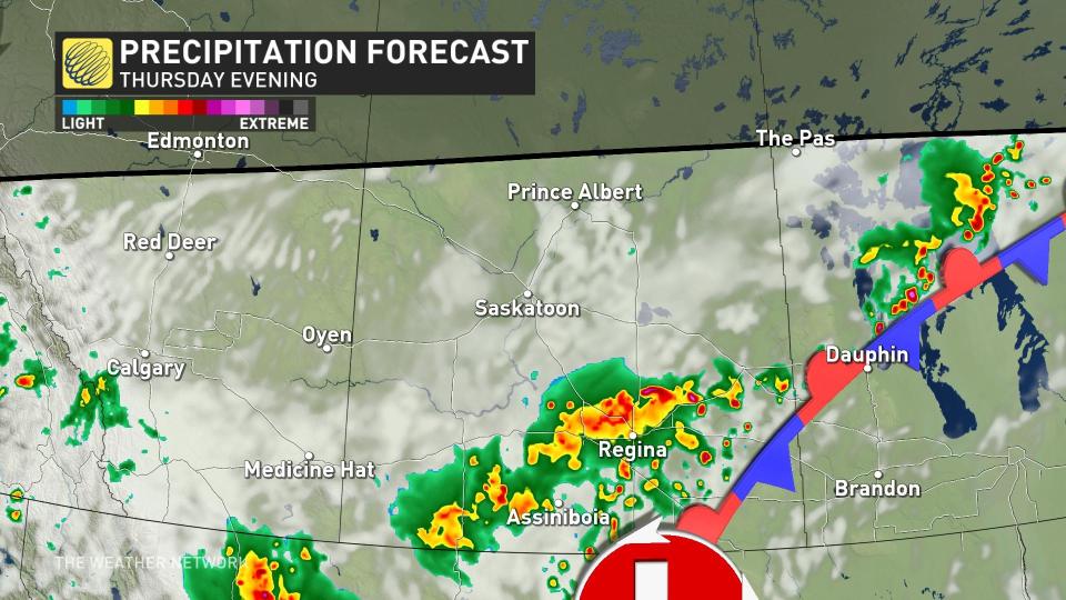
Thursday
Areas: Scattered thunderstorms are forecast to continue Thursday across southern Saskatchewan with the risk area shifting a bit farther east.
Timing: Afternoon and evening

Weather: As a boundary continues to push east across the region, storms will initiate through the late afternoon and into the evening across southeastern parts of Saskatchewan
Severe thunderstorms are likely to develop as strong dynamics will support blustery wind gusts and large hail that could reach golf ball-size or possibly larger.
Late week
As the low-pressure system continues to push east, southern Manitoba should prepare for possible severe weather Friday and into the weekend. Summer-like heat will precede the thunderstorm threat.
Prepare
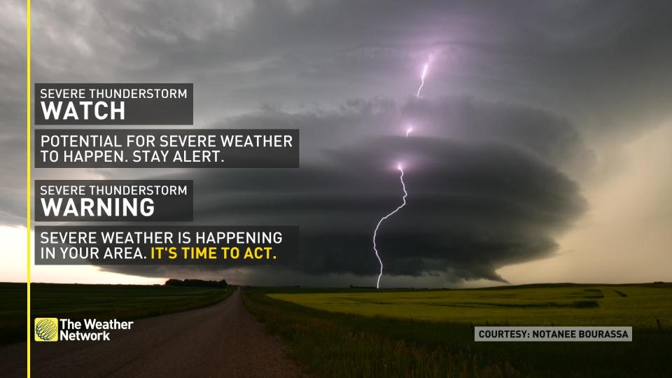
Stay alert and monitor the forecast for updates. Have a plan and a place to head indoors if the weather changes.
Watches mean conditions are favourable for the development of severe thunderstorms.
Warnings mean they are imminent or occurring in your area.
Stay tuned to The Weather Network for more forecast updates on the Prairies.

