Final Idalia forecast: An impact breakdown based on your city for deadly wind and surge
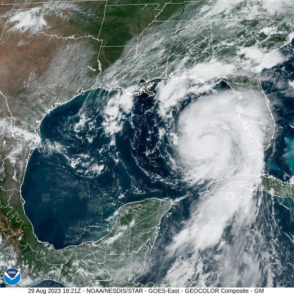
Hurricane Idalia will be the first-ever major hurricane landfall in Apalachee Bay.
Life-threatening and catastrophic surge is certain Wednesday morning in the eastern bay and along the Nature Coast; critical details of local wind impacts remain in flux, but destructive winds are coming to the Big Bend.
Idalia, which became a Category 2 hurricane Tuesday at 5 p.m., will be the hurricane of a generation for the eastern Panhandle.
As of the NHC’s 2 p.m. advisory, Idalia’s maximum sustained winds have increased to 90 mph. As expected, Idalia is in the midst of a period of rapid strengthening that is likely to continue into the early hours of Wednesday morning. The NHC intensity forecast brings Idalia to a high-end Category 3 hurricane just prior to landfall, and a peak at Category 4 intensity is at least a 50-50 chance.
Idalia's impacts will extend well beyond the cone
Remember that the literal maximum sustained winds only occur in a small area of the eyewall, usually offshore; what is important is not maximum intensity, but the fact that Idalia will be a powerful major hurricane with a well-formed core of destructive winds and broad field of tropical-storm-force winds to its east on Wednesday morning.
Idalia is moving north at around 15 mph, or perhaps just a touch west of due north at points today per radar and satellite imagery. The NHC forecast track calls for continued northward movement into Tuesday evening, followed by a gradual bend north-northeast overnight. On this path, NHC has landfall near Steinhatchee in Taylor County around 9 a.m. Wednesday morning.
The range of potential landfall locations continues to narrow, and is likely somewhere from Alligator Point to just east of Steinhatchee between 6 a.m. and noon tomorrow. A hurricane is not a point, and destructive impacts from Idalia, especially surge, will extend over a large part of Florida regardless of its exact track. However, landfall location matters for two reasons:
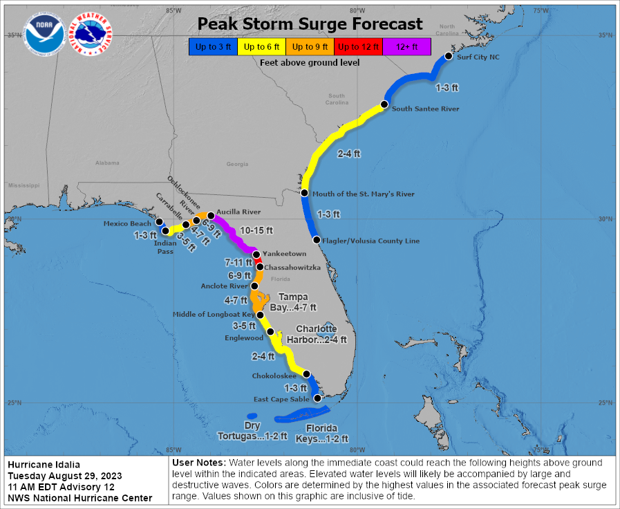
Surge impacts occur near and to the right of the landfall point, relative to the direction of motion of the hurricane. In this case, that means southeast of the storm. Areas west of the landfall point see much lower surge.
Models vs. reality: Why Tallahassee should worry, but Taylor County may end up being landfall point
The truly destructive winds from Idalia will occur in its core, which is likely to be 30-50 miles wide at landfall. Areas outside of the core can get damaging gusts, but not the worst of the hurricane.
So, if you’re in Tallahassee, like me, every inch matters.
A more westward track towards St. Marks means a direct hit from the core in Tallahassee, and a more eastward track into Steinhatchee brings serious bands, but no core. If you’re along the central Apalachee Bay coast, a westward track means catastrophic, devastating surge, rather than just bad surge. This is further complicated by elevated tides due to a full moon: low tide tomorrow in Apalachee Bay is between 8-10 a.m. and high tide is 1-3 p.m, so an earlier landfall would be better.
I still don’t know which of those scenarios will play out. Since last night, there has been a stubborn cluster of models favoring a track into western or central Apalachee Bay, including the GFS and many of the hurricane-specific models like HAFS and HWRF, while the European and British models have held serve into eastern Apalachee Bay.
As always, we need to compare model guidance to the real world.
Idalia is currently moving due north, just east of 85°W, which is the longitude of Apalachicola. Most of the models that take Idalia into western Apalachee Bay show at least a short period of west-of-north movement this afternoon or evening that brings Idalia briefly west of the 85°W red line.
I don’t yet see signs of that west tick as of 3 p.m. on radar; additionally, many of the GFS ensemble members are a little too far west when comparing their short-term forecasts to what Idalia is actually doing.
For that reason I lean (as the NHC does) toward the eastern end of the landfall range.
If I had to guess, I’d put my money on a landfall somewhere in Taylor County. However, in order for that to happen, Idalia is going to have to start moving east-north prior to midnight, and also not cross 85°W before that. I’ll be watching those keys carefully for the rest of the day, and will update you all in the 9 p.m. live video.
Regions of Idalia impact. What to expect based on where you live
In the meantime, let’s take as specific a look as possible at Florida’s region-by-region impacts, from least to worst. (Feel free to skip to your region of interest.)
Southeast Florida, East-central Florida, and Western Panhandle
Miami, Ft. Lauderdale, West Palm Beach, Melbourne, Orlando, Panama City, Destin, and Pensacola are where Idalia’s effects will be relatively minor. Look for periodic bands of showers today and Wednesday, with a few gusts of 35-45 mph possible in those bands, more frequent in east-central Florida and the central Panhandle. No significant surge in these areas, and rainfall of 2 inches or less.
Southwest Florida, including Naples, Fort Myers, and Sarasota:
Southwest Florida’s primary impact will be surge on the order of 2-4’ over usual high tides, subject to local terrain factors and highest farther north. This is not sensitive to track forecast changes. Otherwise, periodic bands, already pushing onshore now, will continue through Wednesday and bring wind gusts of 45-55 mph along the coast, especially towards Sarasota, and occasional gusts of 35-45 mph inland.
Northeast Florida, including Jacksonville, Gainesville, and St. Augustine:
This area is under a Tropical Storm Warning, and low-end sustained tropical storm force winds along the coast north of Flagler Beach are likely Wednesday mid-day. Those winds will be mostly south to north, turning offshore Wednesday evening. This should keep coastal flooding on the more modest side, but 1-3’ of surge is likely.
Areas further inland will likely see a round of wind gusts in the 50-60 mph range sometime Wednesday evening as Idalia makes its closest approach passing to the west. Steady rain tallying 2-4” sets in Wednesday morning, bringing localized flash flooding potential and a few potential tornadoes.
West Central Florida, including Tampa, St. Petersburg, Lakeland, Ocala, and Cedar Key:
The slight shift west in track in the last 24 hours improves the forecast for inland west-central Florida, but does little to change the expectation of destructive storm surge along the Nature Coast, all of which is under Hurricane and Storm Surge Warnings.
Though Idalia will likely to pass around 100 miles west of Tampa overnight, a large area of sustained tropical-storm-force winds out of the south and then southeast on the eastern half of the storm will still bring 4-6’ of surge into Tampa Bay beginning Wednesday morning and continuing into the afternoon.
That’s a lot. Remember how bad things got in comparatively wimpy Tropical Storm Eta in 2020, and don’t mess around if you’re in an evacuation zone.
Farther north along the Nature Coast, likely surge will increase from 5’ or so near Tarpon Springs to 10’ or more around Cedar Key. That might be a little less if Idalia tacks west and a little more if it bends east, but a destructive surge is a virtual lock north of Tampa, especially given heightened tides.
Get out if you are in a low-lying coastal area. Idalia will exceed the 8’ surge seen in Cedar Key in Dennis.
The wind threat in west-central Florida has backed off somewhat, but hurricane-force coastal gusts are still likely north of Spring Hill, with gusts into the 60s likely along the shore in Tampa Bay on Wednesday. Inland wind gusts across west-central Florida will likely top out in the 45-55 mph range, and generalized rainfall totals of 3-6” will bring flood potential in spots. Rain will be heaviest overnight and become more intermittent mid-day Wednesday.
Eastern Panhandle, including Tallahassee, Madison, Apalachicola, Lake City, and Steinhatchee:
This is where the worst of Idalia’s wrath will be felt, though some in the eastern Panhandle will have it worse than others. Precisely where that dividing line will fall in terms of surge and wind impacts will go right down to the wire.
For now, let’s assume an NHC-like track towards Taylor County, perhaps a little west of Steinhatchee. On this path, the eastern Panhandle will see increasingly bands of storms pushing through from the south for the remainder of the day, with heavier and steadier rain beginning after midnight.
In other words, you may have to dodge rain, but you have the rest of Tuesday to prepare for Idalia. You will need to be where you are going before midnight tonight, and stay sheltered through Wednesday afternoon.
As Idalia’s core approaches land, winds will pick up quickly: first along the coast, then inland. Increasingly onshore winds east of the eye, enhanced by the shallow waters and curved coastline of eastern Apalachee Bay, will push a staggering wall of water up to a peak of 10-15’ above normal high tide mid-morning.
This surge is likely east of St. Marks to Cedar Key and possible St. Marks to Apalachicola, but the chances of devastating surge are too high anywhere in Apalachee Bay to not react to the threat.
Coastal residents: evacuate! Learn the lesson from Ian and don’t take a chance with your life. Waters will slowly subside into the afternoon.
Idalia will also have a core of major hurricane winds 30 to 50 miles wide, which is likely to strike portions of coastal Taylor and Dixie Counties with brutal, 110 mph or higher sustained winds and gusts above 130 mph starting around sunrise. Southern Wakulla, southern Jefferson, and coastal Franklin Counties also have a chance of seeing these winds, capable of causing severe structural damage, if the track deviates farther west.
With Idalia unlikely to weaken much, if any, prior to landfall and moving north-northeast at 15-20 mph, these destructive winds will plow inland over the eastern Panhandle through the mid-morning hours.
Wind gusts inland within 15-25 miles on either side of the circulation center will range anywhere from 80-120 mph, even all the way to the Florida-Georgia line.
In Tallahassee, a landfall in western Taylor County, St. Marks, or west would likely put us under that core. If that is the case, damage in Tallahassee will exceed what we saw in Leon County during Hermine or Michael.
A landfall in eastern Taylor County or east probably puts Tallahassee proper just west of the western edge of the outer core, and more in the Michael/Hermine range of 60-75 mph top gusts. It could still go either way; Leon and Wakulla Counties really are on the knife edge here.
Monticello, Madison, and Live Oak are all under the gun for getting the core as well. Stay tuned as the forecast may change into the evening hours.
Wednesday will be a truly frightening day
In short, if you think you have a handle on what a major hurricane coming into Apalachee Bay is going to be like: It’s never happened before, so, no. You don’t. It’s better to overreact than underreact.
Rush all preparations to completion in the eastern Panhandle today, and bear down what will be a truly frightening morning tomorrow. I’ll be liveblogging starting early tomorrow morning to walk you through it, while I have the ability to do so, from WeatherTiger World HQ in Southeast Tallahassee.
Stay safe, Florida, and keep watching the skies.
Dr. Ryan Truchelut is chief meteorologist at WeatherTiger, a Tallahassee start-up providing forensic meteorology and expert witness consulting services, and agricultural and hurricane forecasting subscriptions. Get in touch at ryan@weathertiger.com, and visit weathertiger.com for an enhanced, real-time version of our seasonal outlook.
This article originally appeared on Tallahassee Democrat: Hurricane Idalia forecast: Breaking down impacts for your Florida city

