With Fiona departing, all eyes on a tropical wave to the south. Could it affect Florida?
After a sleepy start to the hurricane season, storm watchers are eyeing a disturbance east of the Windward Islands as the first potentially serious threat to Florida — although it’s too soon to tell for sure.
Computer models are in rare agreement that the system could strengthen into the next tropical storm of the season, which would be called Hermine, and head west into the Caribbean sea over the next few days. By Tuesday, most models put the could-be storm directly south of Cuba.
From there, the spray of potential paths stretches from Belize to the Bahamas, including all of Florida.
Despite the images of the models circulating on social media — some with a black line running directly over Florida — Acting Director of the National Hurricane Center Jamie Rhome warned it was too early to count on impacts.
“There’s a lot of speculation out there about the potential impacts to the U.S.,” he said in a broadcast Wednesday morning. “That is way too premature to go that far.”
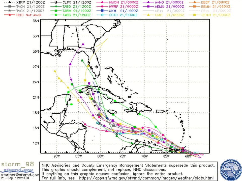
As of Wednesday morning, the tropical wave was east of Trinidad and Tobago and wasn’t quite showing a strong enough circulation or defined center to earn it a formal designation as a tropical depression or tropical storm from the hurricane center. Without a clearly defined center, it’s harder for computer models to accurately predict the track of a storm.
“Until a low-level circulation forms, we won’t be able to say much with certainty about the impacts to the U.S.,” Rhome said.
The hurricane center’s 2 p.m. advisory gave the disturbance a 70% chance of developing in the next two days and a 90% chance of developing this week, unchanged from the morning update. Hurricane hunters are scheduled to investigate the system Wednesday evening.
What has meteorologists concerned, however, is the patch of super warm water this potential disturbance could cross on its way to Cuba, if the models are correct. The slower storm season has left those waters untouched by cooling high winds for months, so the above-average sea surface temperatures are fuel for a more powerful storm.
As a tropical wave gathers strength in the southern Caribbean, oceanic heat content along its path is tremendously high.
If this system develops this weekend, the U.S. is absolutely in play later next week or next weekend.
All interests from TX to FL should monitor. #Tropics pic.twitter.com/4TwTFm8rDW— Atmospheric G2 (@Atmospheric_G2) September 21, 2022
That hot water, coupled with low wind shear, could be a recipe for intensification.
“In general, this is about as good of an environment as you can get in the Atlantic basin,” tweeted Eric Webb, a meteorologist with the National Hurricane Center.
Millions in Caribbean left without power and water in wake of Cat 3 Hurricane Fiona
Weekend development
A speed bump for the development of invest 98, as it’s called until it earns a name, is the after burn from Hurricane Fiona, which slammed Puerto Rico and the Dominican Republic with torrential rains and 85 mph winds on Sunday and Monday.
Fiona, now a Category 4 bearing down on Bermuda, sucked up all the moisture in the air, leaving patches of dry air in its wake, which isn’t good for storm development.
As the storm moved north, wind shear wrapped around its southern tail, where it will likely interfere with the tropical wave’s development for the next day or two, Craig Setzer, a former CBS4 meteorologist turned weather vlogger, said in a Youtube broadcast about the disturbance.
“It may not stop it, it may not develop any more than a strong tropical wave as it enters the Caribbean ... but it’s a temporary limiting factor,” he said.
Here's what we know so far about tropical activity in the #Gulf late next week. #98L pic.twitter.com/DyctDw0o3x
— Jeff Huffman (@HuffmanHeadsUp) September 20, 2022
If a tropical storm does form in the next few days so close to South America, it would be unusual. Hurricane scientists call the area the “Caribbean graveyard” due to its historically unfriendly conditions for storm development.
According to the latest models, those unfriendly conditions could quickly flip to friendly over the weekend, opening up the door for storm formation or strengthening. Around that time, meteorologists will have a better sense of who might need to prepare for an incoming storm.
“For South Florida, this is a watch and wait,” Michael Lowry, hurricane specialist for Channel 10 news, wrote in his newsletter.
What’s ahead for hurricane season? NOAA has an update and a prediction on storms

