Firefighters battle new lightning fires, welcome rain over parts of Northern California
Firefighters battling wildfires were on high alert Thursday and Friday morning as fast-moving thunderstorms brought strong wind gusts and dry lighting but also some rain to much of the western half of the North State.
Lighting ignited a few small fires across northwest Siskiyou County, including one in the Happy Camp Complex.
The National Weather issued a red flag warning due to high fire danger, in effect for parts of Del Norte, Humboldt, Siskiyou and Trinity counties until Friday evening. More scattered thunderstorms could produce wind gusts up to 40 mph, spreading uncontained fires, according to the weather service.
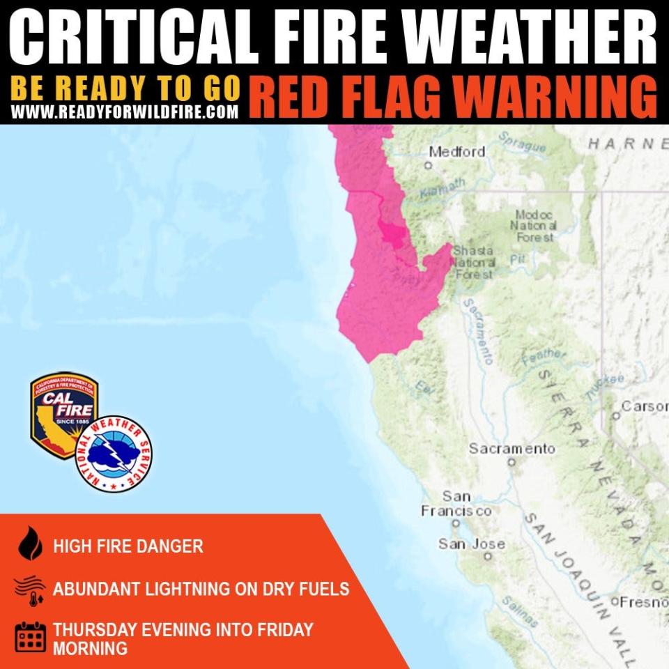
Motorists driving near burn scars and on mountain highways and roads should watch for mud and rock slides in parts of Siskiyou and Trinity counties, according to the National Weather Service, which issued flood warnings for parts of those counties late in the week.
Here is what we know on Friday morning about fires burning in the North State.
Deep Fire
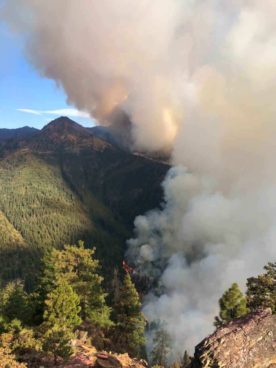
The Deep Fire ― burning in the Shasta-Trinity National Forest, southwest of Trinity Center and northwest of Trinity Lake in Trinity County ― stayed calm for the third day in a row, remaining 3,823 acres in size. Winds from thunderstorms that moved over areas to the west and north of the fire on Thursday didn't reach the blaze, according to the U.S. Forest Service.
That fire is now 58% contained, up from 51% on Thursday morning. Crews worked Thursday to build containment lines along the fire's southeastern edge, and to close lines at "rocky outcroppings to the east" of the fire. "Hotshot crews will continue to work on that today, with the goal of completing that line in the next several days, if conditions permit," the agency said.
Firefighters patrolling the Stuart Fork drainage are still spotting hot debris rolling down steep terrain, and are fighting burning dead trees, the forest service said.
Hot spots are flaring up along the Deep Fire's northern flank south of Little Salt Creek, and crews are patrolling the area to make sure they don't spread, while the eastern edge of the fire seems stable after it moved up against rock.
Through Sunday, firefighters expect warm weather to dry out brush, making it more flammable. Light winds could push the fire up hill in the afternoons, and down hill at night.
Meteorologists don't expect mountain thunderstorms to roll over the Deep Fire on Friday, the forest service said.
Note to readers: We’ve made this story free as an important public service. If you are able, help power local journalism. Subscribe to the Redding Record Searchlight.
Lightning ignited the Deep Fire around 7 a.m. on Aug. 15, east of Stuart Fork and west of Siligo Meadow.
Happy Camp Complex
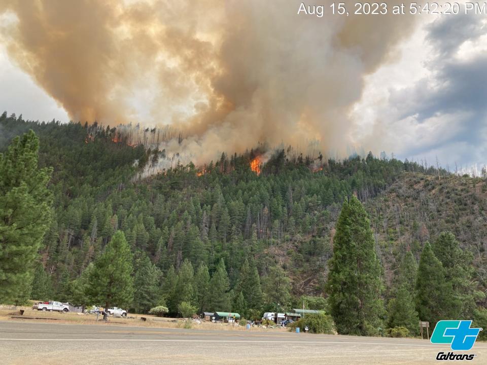
The Happy Camp Complex of fires, burning in the Klamath National Forest in Siskiyou County, scorched a total of 15,972 acres, up from 14,037 acres on Thursday morning. Blazes are 11% contained, up from 9% on Thursday, according to the forest service.
Brush that dried out after last week's wet storms, and dry thunderstorms rolling over Siskiyou County kicked up fires on Thursday, and started at least one new fire. Flames that stayed near the ground earlier in the week are now catching trees on fire as temperatures dry them out.
Firefighters snuffed a new lightning fire north of the Gold Fire on Thursday. They're holding the blaze at "just over an acre." Crews will mop up the area on Friday, according to an update issued by the forest service on Friday morning.
Late Thursday night, the storm turned wet, dampening the brush and cooling the air in the western part of the complex, slowing the fires' growth.
"Even with the increased wind, primary fire lines held, except the dozer line off the 24 Road north of the Swillup Fire."
Firefighters had to pull out of the Swillup area because of falling trees and poor visibility, according to the report.
Hot spots popped up in the 2,861-acre Elliot Fire, Ufish and Swillup burn areas and hot debris from fires is rolling downhill in steep terrain, igniting brush at lower elevations. Crews will spend Friday and the weekend watching for these hazards.
Also on Friday, crews plan to work to hold Dillon Creek and the Highway 96 corridor as the Elliot Fire creeps toward the highway. They will also work near Highway 96 at 24 Road, where flames crossed the highway; and continue building lines around the Ufish and Malone fires.
On the west side of the complex, the 4,289-acre Elliot Fire is 3% contained, the 276-acre Malone Fire is 7% contained and the 1,161-acre Ufish Fire and 1,714-acre Swillup Fire aren't contained.
On the east side of the complex, aircraft dropped retardant on the east flank of the Head Fire, slowing the fire’s spread on Thursday. Since its start, the blaze scorched 6,648 acres, killed one person and badly injured at least one other. Crews will continue to build containment lines around the fire on Friday, which was 19% contained Friday morning. "The greatest amount of work remaining on the Head Fire is across the north edge of the fire," the update said.
The tiny Block Fire and 81-acre Townsend Fire are fully contained. The 294-acre Den Fire is 95% contained, the 968-acre Gold Fire is 65% contained, the 367-acre Scott Fire is 50% contained and the 174-acre Lake Fire is 5% contained.
Lightning ignited most of the fires in the Happy Camp Complex on Aug. 16, according to the California Department of Forestry and Fire Protection and the forest service.
2023 Six Rivers National Forest Lightning Complex and Redwood Lightning Complex
Light rain fell Thursday night, helping calm fires that spread during the day in the SRF Lightning Complex and Redwood Lightning Complex. Those fires burned a total of 7693.5 acres in Humboldt and Siskiyou counties, up from 5,488 acres on Thursday. Total containment on the fires remained 15% since Thursday morning, according to the forest service.
Crews worked Thursday to slow the 1,748-acre Pearch Fire's spread west towards Orleans. Helicopters dropped water from buckets on the hottest parts of the fire. Crews also worked to protect structures including the Orleans pump house. Evacuation warnings are in place for people living in and near Orleans. Go to linktr.ee/srffirepio for more information.
In the Redwood National and State Parks Area, the 701-acre Lost Fire is 5% contained. Crews held it back on Holter Ridge, but a small portion of the fire spread down hill into old growth redwood forest.
The Devil and Glenn fires are fully contained. Crews will patrol the edges of the burn area to make sure those fires don't jump containment lines.
South of Hoopa, the 1,684-acre Lone Pine Fire is 45% contained. It's burning in the Horse Linto Creek watershed, east of the Trinity River, near the Tish Tang Campground and Sugar Bowl Ranch. The fire was calm Thursday night, according to the forest service.
Other fires in the complexes include the fully contained 19.9-acre Iron Fire above Ti-Bar Wildland Fire Station, the hard-to-reach 71-acre Hancock Fire in the Wooley Creek area in the Marble Mountain Wilderness, the 1,653-acre Mosquito Fire burning near Bluff Creek and the unstaffed 1,164-acre Bluff #1 Fire.
South Fork Complex
The South Fork Complex of fires burning in the Shasta-Trinity and Six Rivers national forests has remained 20% contained since Wednesday, according to the forest service.
The 595-acre 3-9 Fire remains uncontained. Firefighters completed hose line around the fire's north flank and are mopping up the area. Crews will also build hose lines around other parts of the fire on Friday. South of the fire, crews are working to contain the 3-9 using the Berry Summit-Mad River Road and other mountain roads, and are bulldozing space near the fire. Firefighters are looking for access points they can enter to fight the fire on its southwest flank, burning in steep terrain. Crews will bulldoze line along the southern flank of the fire to contain spot fires and helicopters are dropping retardant on the fire.
The 983-acre Pilot Fire is 36% contained. Crews finished containment lines along the fire's northeastern flank. They'll work the western flank of the fire on Friday.
The 31-acre Sulphur Fire is 95% contained and the 3-acre Pellitreau Fire is 100% contained. Crews will continue mopping up those burn areas to make sure the fires don't jump containment lines.
Smith River Complex
Fires burning in the Smith River Complex in the Six Rivers National Forest are still not contained. The fires burned a total of 57,219 acres in north Del Norte County along the California-Oregon border, up from 52,563 acres on Thursday morning, officials said.
In the south part of the complex, crews completed hose line from the French Hill Road, south to Highway 199 on Thursday. They'll spend Friday defending the town of Gasquet and surrounding communities and will construct lines from the 305 Road to the North Fork of the Smith River.
Hot shot crews battled the Kelly Fire along the Highway 199 corridor on Thursday, clearing enough of the area to allow Pacific Power and California Department of Transportation crews access to places where infrastructure needed repairs.
In the north part of the complex, burning in California and Oregon, thick smoke stopped efforts to fight the Kelly Fire's north flank from the air. Firefighters worked the fire west of Highway 199, "developing fire lines near Gilligan Butte and Blue Creek to the Lone Mountain Road." On Friday, crews will continue to set up sprinkler systems to help protect structures near the 4402 Road.
Winds pushed the Kelly Fire north into Josephine County, Oregon, prompting evacuations for residents living near Highway 199 south of O’Brien, from mile post 38 to the California border. The county also issued evacuation warnings for people living in O’Brien and Takilma, north to Cave Junction. The Red Cross opened an evacuation shelter at Rogue Community College in Grants Pass, Oregon; and evacuees can take livestock to the Josephine County Fair grounds. For evacuation information go to bit.ly/3YS9xMP.
Damp air and cooler temperatures blowing inland from the ocean are on the way, according to weather forecasts. Forest service officials said that should help calm fires over the weekend.
Jessica Skropanic is a features reporter for the Record Searchlight/USA Today Network. She covers science, arts, social issues and news stories. Follow her on Twitter @RS_JSkropanic and on Facebook. Join Jessica in the Get Out! Nor Cal recreation Facebook group. To support and sustain this work, please subscribe today. Thank you.
This article originally appeared on Redding Record Searchlight: Firefighters battle wildfires burning in Northern California

