Firefighters make progress on Head and Deep fires and other North State wildfires
Firefighters made progress containing wildfires in national and state forests across the North State after cool rainy weather dampened brush and trees, slowing blazes earlier in the week.
The weather reprieve maybe short lived.
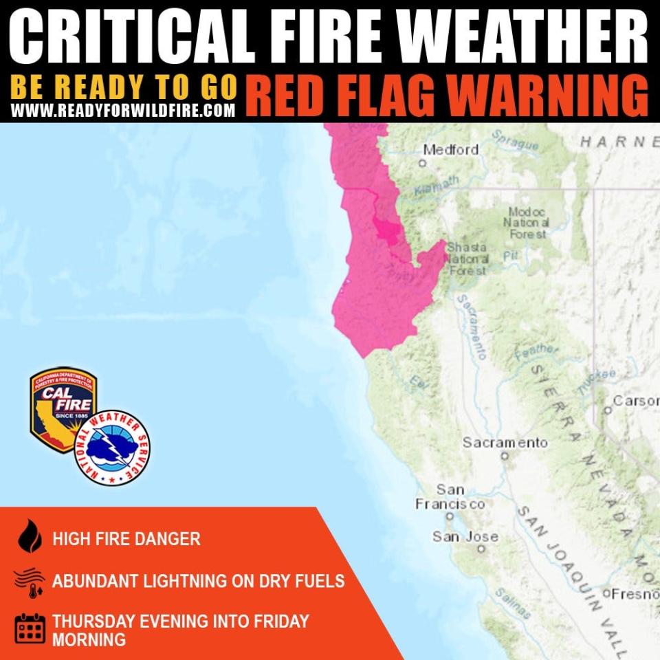
The National Weather issued a red flag warning, cautioning fire danger will be high on Thursday evening through Friday evening. Scattered thunderstorms could produce lightning, igniting more fires and wind gusts up to 40 mph could spread the fires. The warning covers parts of Del Norte, Humboldt, Siskiyou and Trinity counties, according to the weather service.
On Thursday, crews will continue to construct containment lines around fires before storms arrive in those areas and in parts of the North State where hot weather will dry out grasses, trees and the air, allowing blazes to spread more easily.
Here are updates on fires burning in the North State as of Thursday morning.
Deep Fire
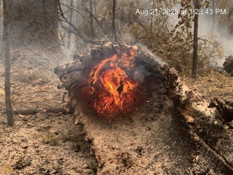
On Wednesday, firefighters made significant progress battling the Deep Fire burning southwest of Trinity Center, west of Trinity Lake in Trinity County.
That fire is now 51% contained, up from 16% on Wednesday morning. It remained 3,823 acres in size since Tuesday night, according to the Shasta-Trinity National Forest.
Note to readers: We’ve made this story free as an important public service. If you are able, help power local journalism. Subscribe to the Redding Record Searchlight.
Although parts of the fire are still burning at very hot temperatures, those areas are mostly isolated hot spots. The blaze pushed up against rocks and sparse brush on its north and east flanks, helping slow it down, the agency reported.
The agency said crews are scouting for chances to contain the Deep Fire's south flank, where the fire is actively burning. Their goal is to stop the fire before the vegetation dries out anymore and allowing flames to spread.
Firefighters report burning brush and debris are rolling down steep terrain on the west side of the Stuart Fork Trail. That hot debris could ignite brush beyond the burn scar, so firefighters are patrolling the area, the forest service.
Parts of the North State covered under the weather service's red flag warning don't include the Deep Fire burn area. However, crews are preparing for strong winds that could speed the fire's growth. "Areas of particular concern are the northwest corner of the fire near Oak Flat, and the southern area near Cherry Flat," the agency said.
Happy Camp Complex
The Happy Camp Complex burning in Siskiyou County scorched 14,037 acres, up from 11,616 acres on Wednesday morning. It's 9% contained, according to the Klamath National Forest.
The Swillup, Ufish and Malone fires are still growing.
Steep terrain is making it hard for firefighters to stop the Malone Fire's edge, in part because burning debris is "rolling downhill from Titus Ridge and igniting vegetation below," the agency said.
Firefighters weren't able to attack the Ufish Fire at it's edges on Wednesday because it's also burning in very steep terrain.
The Canyon, Three Creeks and Elliot fires combined into one blaze on Wednesday, totaling 3,306 acres. It's now called the Elliot Fire. Crews are using forest roads, Dillion Creek and Highway 96 to surround active parts of the fire, according to a forest service update.
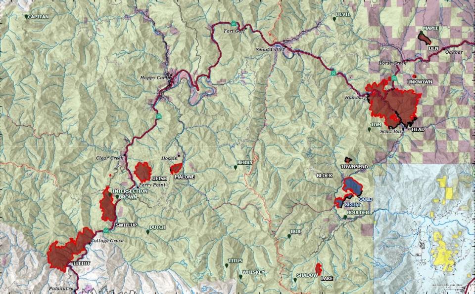
Firefighters made progress on containment lines around the complex's largest fire, the Head Fire. The 6,489-acre blaze ― which killed a Scott Bar man and wounded at least one other person ― is 13% contained, up from 5% on Tuesday night.
Crews made so much progress on the Den and Townsend fires, staff will move to fight more active fires on Thursday. Firefighters will also continue to build containment lines around the Gold and Scott fires.
More: 'Unimaginable loss.' Siskiyou woman in burn unit mourns husband's death in Head Fire
The wildfire forced 755 people to evacuate the area, destroyed nine structures, damaged two more and threatens another 1,609. Evacuation orders and warnings remain in place, with stretches of Scott River Road and Highway 96 closed, according to the California Department of Transportation. The Pacific Crest Trail is closed between Etna Summit and the Oregon Border, and parts of Klamath National Forest are closed and fire restrictions in place, the forest service said.
Firefighting and law enforcement officials will host a community meeting to update the public at 5:30 p.m. Thursday, Aug. 24 at the Quartz Valley Indian Reservation, 9040 Sniktaw Lane in Fort Jones.
2023 Six Rivers National Forest Lightning Complex and Redwood Lightning Complex
The SRF Lightning Complex and Redwood Lightning Complex of fires burned a total of 5,488 acres in Humboldt and Siskiyou counties and are 15% contained.
In Redwood National and State parks, the 529-acre Lost Fire burning in the Lost Man watershed isn’t contained. “Crews have held the fire on Holter Ridge (but) a small portion of the fire has slowly spread downslope into old growth redwood forest,” the agency said.
In the Hoopa area near the Humboldt-Trinity counties border, the 1,678-acre Lone Pine Fire in the Horse Linto Creek watershed is 45% contained. Crews are securing containment lines and snuffing out hot spots, according to a forest service update.
The Pearch Fire east of Orleans scorched 981 acres. Crews will work on containment lines to stop the blaze from spreading towards Orleans, but evacuation warnings are still in place, the update said.
Steep terrain is making it hard for firefighters to reach the 30-acre Hancock fire, burning in the Wooley Creek area in the Marble Mountain Wilderness. Crews are building containment lines around the 1,061-acre Mosquito fire is burning near Bluff Creek, north of Mosquito Lake.
The Iron Fire above the Ti-Bar Wildland Fire Station, the Devil Fire and the Glenn Fire are fully contained.
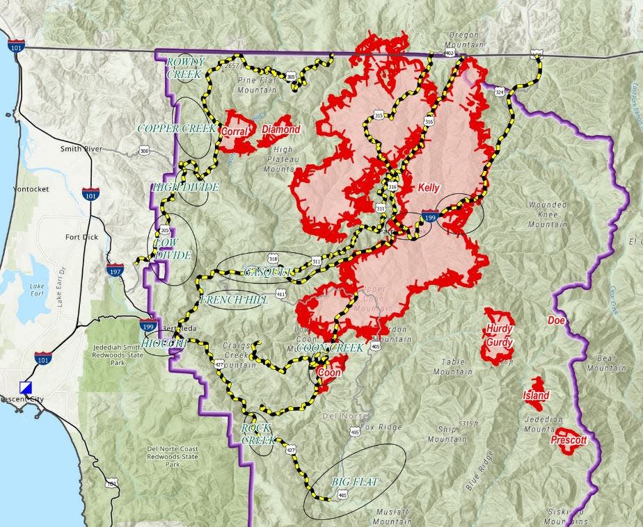
Smith River Complex
More than two dozen fires burning in the Smith River Complex scorched 52,563 acres on Thursday, up from 47,140 acres on Wednesday morning. Those fires are burning in Six Rivers National Forest in north Del Norte County, northeast of High Plateau Mountain at the California-Oregon border.
Most of that growth was the Kelly Fire spreading between the transmission corridor and Elk Camp Ridge Road. The fire also spread across Highway 199 along the 411 Road above Darlingtonia, according to a forest service update.
County and state agencies will host a community meeting to update the public at 6 p.m. on Thursday, Aug. 24 at the staging area across from 30159 Redwood Highway in Cave Junction. It will also be live streamed on Facebook
The Coon Fire grew towards the Kelly Fire, moving northwest between Coon and Gordon creeks, the update said.
Crews made progress on Wednesday night on the Corral Fire's western flank, clearing the 305 Road to use it as a barrier to keep the fire from moving south.
None of the fires are contained, forest service staff said on Thursday morning.
South Fork Complex
The South Fork Complex of fires burning in the Shasta-Trinity and Six Rivers national forests has remained 20% contained since Wednesday, according to the forest service.
As of Thursday morning, the 1,430-acre 3-9 Fire is not contained. Helicopters are dropping retardant in the area and firefighters are building containment lines around the southeastern edge of the fire. They'll also clear roads along Pilot Creek and the fire's southwestern edge to limit any spread.
The 913-acre Pilot Fire is 26% contained. Crews constructed hose/handline around much of the fire and plan to work on containment and snuff hot spots in the burn area on Thursday, the agency said.
The three-acre Pellitreau Fire is fully contained and the 31-acre Sulphur Fire is 95% contained.
Evacuation warnings remained in effect Thursday morning.
Jessica Skropanic is a features reporter for the Record Searchlight/USA Today Network. She covers science, arts, social issues and news stories. Follow her on Twitter @RS_JSkropanic and on Facebook. Join Jessica in the Get Out! Nor Cal recreation Facebook group. To support and sustain this work, please subscribe today. Thank you.
This article originally appeared on Redding Record Searchlight: News about fires burning in Siskiyou, Trinity, North Coast counties

