First of 2 cold fronts brings welcome relief. Traveling for Thanksgiving? You won't be alone
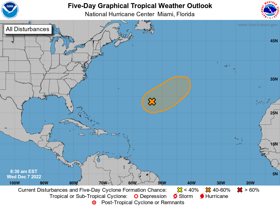
Conditions continue to remain quiet in the Atlantic, with no tropical cyclones expected over the next five days, according to the latest advisory from the National Hurricane Center.
The first of two cold fronts is bringing cooler weather to Florida this morning, bringing relief from above-average temperatures.
With the official end of the Atlantic hurricane season less than two weeks away — Nov. 30 — conditions are making it unlikely that another storm could form.
Cone of uncertainty: Many people misunderstand this famous hurricane forecast graphic. It can be a deadly mistake.
Coastal living comes with a price: After Hurricane Ian, Florida forced to rethink its cycle of rebuilding
Did sharks leave? Experts discuss hurricanes' impact on wildlife
What the science says: Is climate change fueling massive hurricanes in the Atlantic?
Late-season storms typically form in the Caribbean, according to AccuWeather chief meteorologist Bernie Rayno. Dry air and wind sheer in the area currently make development difficult.
Even if one were to develop over the coming days, a trough in the jet stream would steer it into the Atlantic and away from the U.S., Rayno said.
Owen is the next name of the season.
Cold fronts bring drop in temperatures to Florida
A cold front that moved down the state Wednesday is bringing welcome relief from above-average temperatures, according to the Florida Division of Emergency Management.
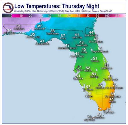
Overnight temperatures across North and Central Florida were expected to drop into the 30s and 40s, with temperatures in South Florida reaching the 50s and 60s. Chances of frost are forecast to increase across the Panhandle Thursday night, with temperatures dropping into the 30s.
Rain chances are expected to increase later in the week for Central and South Florida.
The cold front is expected to stall over South Florida today. A few showers are possible along the Treasure Coast, Southeast Florida, and the Keys as it pushes southward this morning.
Temperatures will drop again Thursday night as a strong area of high pressure continues to bring cold and dry air to the state.
Several areas in North Florida will see temperatures down in the low to mid 30s, increasing the chance for frost late Thursday and early Friday morning. Colder air will sink south, with temperatures in the 40s just north of the I-4 corridor. South of the I-4 corridor, temperatures will drop into the 50s and 60s in South Florida.
A second cold front will approach from the west overnight Friday and into Saturday morning, bringing another round of cooler and drier air.
The front could bring scattered showers over Central and South Florida Saturday morning and into the afternoon. Mostly cloudy skies return across the state by the afternoon. High temperatures in the upper 50s to 60s across the Panhandle and 70s for the rest of the state are expected.
Traveling for Thanksgiving? You won't be alone
AAA is predicting more than 54 million people will be traveling 50 miles or more from home this Thanksgiving. That's approaching pre-pandemic levels.
Almost 49 million are expected to drive to their destinations, and could face record high gas prices. On Thanksgiving Day, the national average for gas is projected to be $3.68 per gallon, about 20 cents higher than last year's Thanksgiving, according to a recent report by GasBuddy.
More Thanksgiving news to use
►Americans will face record-high gas prices for Thanksgiving travel
►Black Friday 2022: Learn more about the best deals and biggest sales going on this year
►Yes, plane tickets are pricier. Here’s how much more you’re paying, according to Adobe.
►Traveling abroad? Make sure to check this on your passport or it might cost you.
The last record-high for Thanksgiving gas prices was in 2012, with a national average of $3.44.
More than 4 million will be flying, an increase of more than 330,000 travelers over 2021.
If you're driving, expect severe congestion on highways in and around Atlanta, Chicago, New York City and Los Angeles, according to INRIX, a transportation analytics firm.
To avoid the most hectic times, INRIX recommends traveling early in the morning on Wednesday or before 11 a.m. on Thanksgiving Day. Avoid peak times between 4 and 8 p.m. Friday through Sunday.
Early Thanksgiving weather forecast could pose problems for some travelers

The biggest trouble spot in terms of weather on Nov. 23 will be the western U.S., including such cities as Seattle, Salt Lake City and Denver, according to AccuWeather.
"We are expecting big travel disruptions from wet, windy and snowy weather in the Northwest and Northern California," AccuWeather Senior Meteorologist Paul Pastelok said. "This intense weather will extend east into the northern Rockies."
Chilly but dry weather is expected farther east, including New York City, Boston, Chicago and Atlanta.
A cold front interacting with warm, moist air from the Gulf of Mexico could bring rain and thunderstorms over parts of the southern Plains and Mississippi Valley. This could lead to delays for motorists as well as those traveling by air, according to AccuWeather.
What's in the tropics?
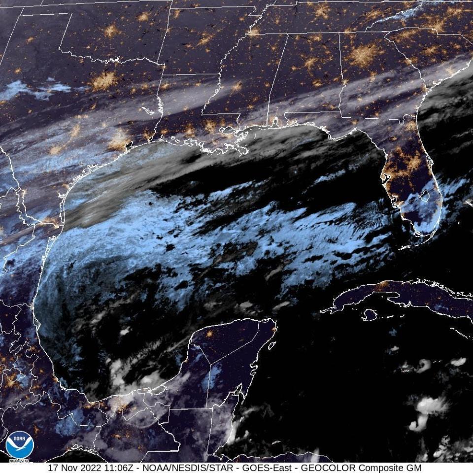
Here's the latest tropical update from the NHC as of 7 a.m. Nov. 17:
While nothing tropical is expected to develop over the next several days, forecasters urge all residents to continue monitoring the tropics and to always be prepared.
When is the Atlantic hurricane season?
The Atlantic hurricane season runs from June 1 through Nov. 30.
When is the peak of hurricane season?

The peak of the season was Sept. 10, with the most activity happening between mid-August and mid-October, according to the Hurricane Center.
Weather watches and warnings issued for your area
If you can't see any local weather warnings here, you'll need to open this story in a web browser.
Tropical forecast over next five days
See the National Hurricane Center's five-day graphical tropical weather outlook below.
Excessive rainfall forecast
What's out there?
Systems currently being monitored by the National Hurricane Center.
What's next?
We will continue to update our tropical weather coverage daily. Download your local site's app to ensure you're always connected to the news. And look at our special subscription offers here.
This article originally appeared on Palm Beach Post: Florida weather: 1 of 2 cold fronts arrives. Thanksgiving travel

