Thousands remain without power after storm rolls through NC. Schools announce delays
A powerful low-pressure system brought heavy rain and strong winds across the state, unfurling a storm that caused thousands of power outages and was blamed for killing one person in Catawba County.
Over 173,000 households were without power at 7 p.m., according to North Carolina Emergency Management’s website. Mecklenburg County accounted for over 23,000 outages while Wake County reported 19,570.
By 10 p.m., the number of outages had fallen to 143,700 statewide. Durham, Johnston, Orange, Chatham, Lee and Harnett County school districts announced they would operate on a two-hour delay Wednesday.
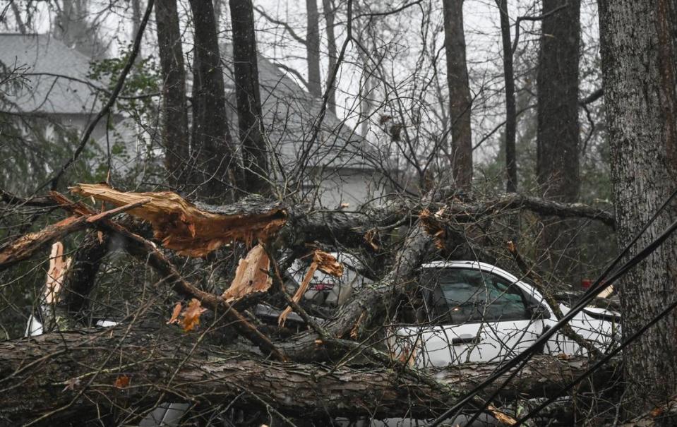
The Hickory Daily Record reported that Catawba County spokeswoman Amy McCauley confirmed the fatality along with two injuries. McCauley told the paper there was a report of a collapsed structure at a mobile home park in Claremont and that many trees are down in that area.
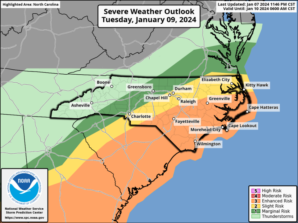
The National Weather Service issued a tornado warning for Montgomery and Stanly counties that was set to expire at 4 p.m., and another for Moore, Harnett, Cumberland, Lee, Sampson and Hoke counties, set to expire at 5 p.m.
When we’ll see the worst weather in the Triangle
The heaviest rains and strongest winds from the storm were expected between 2 p.m. and 9 p.m. for central and Eastern North Carolina.
The National Weather Service issued a tornado watch Tuesday afternoon for most of central and Eastern North Carolina until until 9 p.m.
As a result of expected worsening conditions, Morrisville and Raleigh canceled council meetings for Tuesday. Raleigh’s planned 4 p.m. work session and 7 p.m. public comment session are both canceled. Public comment will be heard at the Jan. 16 session that begins at 1 p.m.
Power outages reported across the state
Power outages hit early. In the Sandhills, a section of Sanford was in the dark for about an hour before Duke Energy was able to bring customers back online.
By 7 p.m., the state reported that more than 173,000 customers were without power, with many reported in the Triangle and eastern North Carolina.
At 10 p.m., Mecklenburg County had the most outages with over 18,600 reported. Craven County had 15,009.
Flooding expected with heavy rain, high winds
North Carolina had braced for the storm. Residents cleared grocery shelves of bread, beer and milk days before Gov. Roy Cooper declared a state of emergency in order to have resources ready to deal with major problems.
Heavy rain from the storm — up to 5 inches in a few places in the mountains and foothills, and 1.5 inches to 3 inches in most of the rest of the state — could cause flooding in rivers and low-lying areas, forecasters said.
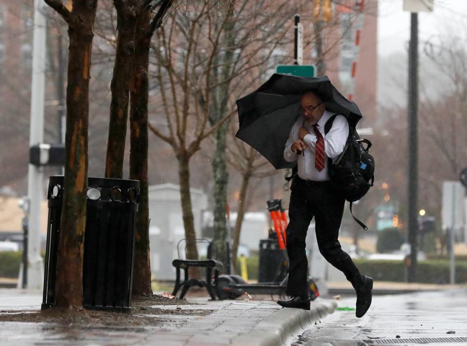
Central North Carolina, including Raleigh, Durham and Chapel Hill, will likely see at least 1.5 inches of rain and sustained winds of 15 to 25 mph, with gusts up to 45 mph.

Roads closed by trees, power lines and flooding
Dozens of roads in central and western North Carolina were closed Tuesday afternoon because of fallen trees and power lines. They included U.S. 70 and secondary roads near the site of the downed trees in Catawba County.
In Raleigh, police said power outages had knocked out traffic signals along South Saunders Street from I-40 to Tryon Rd.
Intersections with malfunctioning traffic lights should be treated like four-way stops.
Raleigh also urged residents to bring their trash and recycling carts in if they had been placed near the street. Collection is suspended until Wednesday, the city said, when carts should be at the curb by 6 a.m.
Just after 5 p.m., the N.C Department of Transportation announced that I-95 was closed in both directions around Rocky Mount, but the interstate was reopened by 6:30 p.m. The department said on X that power lines across the roadway had made it impassible.
After 7 p.m., a section of N.C. 86 from near Hawkins Road to Burton Road in Hillsborough was closed because of downed trees and power lines. Crews weren’t expected to have it cleared until midnight.
High seas along NC coast
Along the coast, conditions on Pamlico Sound were already rough enough Tuesday morning that the N.C. Department of Transportation suspended ferry service between Ocracoke and both Swan Quarter and Cedar Island starting at 7 a.m. The Southport-Fort Fisher and Cherry Branch-Minnesott Beach ferries were halted later in the morning. NCDOT doesn’t expect to resume ferry service until midday Wednesday.
In an afternoon update, the National Weather Service said seas along the N.C. coast were building faster than expected, and conditions would worsen there through the day, especially along the Outer Banks and Carteret County. Seas will build through the day, forecasters said, peaking at 15-25 feet. Hurricane-force wind gusts are likely across the coastal waters and the Pamlico Sound Tuesday evening, forecasters said.
This story will be updated throughout the day.

