First major storm of the season may impact West Coast next week


The first week of November across the Pacific Northwest has already proved to be much more active than conditions throughout October. A parade of storms has plagued the region since the middle of last week, and the caboose of that storm train advanced through the region Tuesday evening.
In the first week of November, locations such as Seattle and Portland, Oregon, have already observed rainfall amounts well above the monthly totals recorded for the entirety of October. Seattle has totaled just over 4 inches since November kicked off, while Portland recorded rainfall amounts just shy of the 4-inch mark.
In western Washington and Oregon, the relatively dry conditions over the summer put some locations on track for rainfall below the historical average in 2023. As a result, the stretch of wet weather during the first week of November was the first notable period of rain for many spots since the springtime.
 |
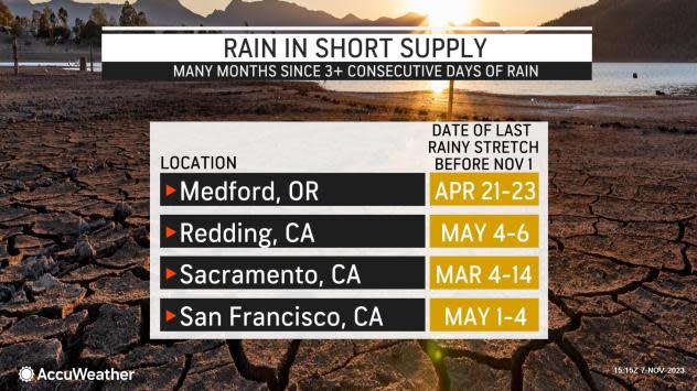
Residents in Redding, California, for example, haven't observed a consecutive three-day rainy stretch since May 4-6, while records from San Francisco show the last rainy stretch took place from May 1-4.
In Medford, Oregon, the last notable rainy period occurred from April 21-23. Over the summer months from June 1 to Sept. 1, only 0.72 of an inch of rain was recorded in Medford, roughly 57% of the historical average during that time, and the rain only happened sporadically.
The brief stretch of dry weather that lasted from Tuesday night into Wednesday will come to an end by Thursday, as another potent cold front is on track to move inland.
As the front approaches the coast of Washington and Oregon on Thursday, offshore winds will pick up significantly. Boaters, particularly inexperienced mariners and those operating smaller vessels, are being urged by forecasters to take caution during this time, as gusts could reach peak values of 30-40 mph and wave swells can climb to hazardous levels.
 |
Rain will focus mainly along the coast from British Columbia to northwest California from Thursday to Thursday night. After the recent rounds of heavy rain, some locations may be more vulnerable to additional precipitation and flooding may be more likely.
Rainfall totals are expected to range from 0.25-0.75 of an inch along the foothills of the Cascades and Coastal Range as the front tracks onshore Thursday. Locally higher totals around 1.00-1.25 inches can occur along the western slopes of the Olympic Mountains.
Cooler air will accompany the storm and allow for snowflakes across the higher terrain of the Olympic Mountains, Cascades and portions of the northern Rockies in Idaho.
"As is often the case when storms or cold fronts swing through the Cascades, snow levels tend to rise as the front approaches and then fall as the feature tracks away from the region," AccuWeather Senior Meteorologist Alex Sosnowski explained.
Sosnowski added that snow levels in the Washington Cascades could rise to a bit above 3,500 feet as this front draws closer, then may fall to around 3,000 feet. Motorists traveling along passes in Washington state may face some travel disruptions as a slushy coating to a few inches of snow spreads across the higher terrain. The highest peaks across the Northern Cascades could contend with up to 3-6 inches of snow, forecasters say.
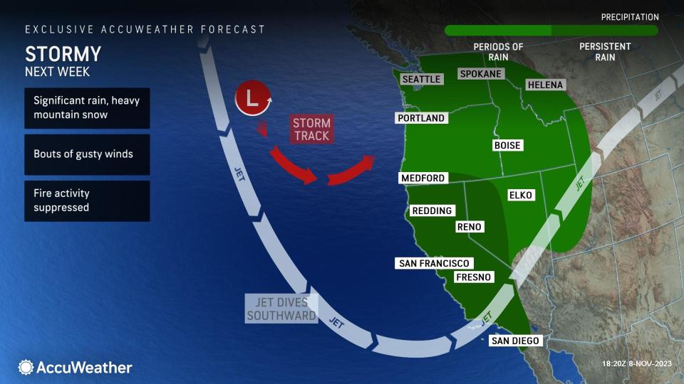
Next week, additional chances for rain and mountain snow will sweep across the West, this time potentially reaching farther south than recent storms.
A southward plunge in the jet stream may usher in rounds of heavy rain to parts of California, Nevada and Utah in addition to the Pacific Northwest. This southward pattern shift may provide an opportunity for the first big storm of the season across parts of California.
 |
Although it is several days away, there is growing concern among AccuWeather forecasters that copious amounts of rain, gusty winds and heavy mountain snowfall may arrive in full force next week.
"Heavy rain and high winds are expected along the central and northern coasts of California. There can be periods of rain and some wind for the Southern California coast and western Oregon. Heavy snow will most likely measured in feet in portions of the Sierras," AccuWeather Lead Long-Range Forecaster Paul Pastelok said.
The ample rainfall that this storm may bring to the region could have a positive impact on the wildfire risk for the upcoming month or so.
"This [pattern] should nearly put a lid on the fire season in central and northern areas of California for the remainder of 2023," Pastelok said.
Continue to monitor AccuWeather.com for updates regarding the developing storm next week.
Want next-level safety, ad-free? Unlock advanced, hyperlocal severe weather alerts when you subscribe to Premium+ on the AccuWeather app. AccuWeather Alerts™ are prompted by our expert meteorologists who monitor and analyze dangerous weather risks 24/7 to keep you and your family safer.
