Strong cold front brings tornadoes, freeze warnings to Florida
Get ready for some cooler weather.
The first strong cold front of the season is making its way down Florida, bringing some of the coldest temperatures of the season.
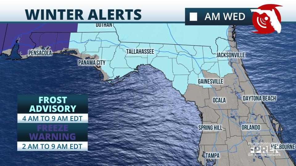
Freeze warnings and frost advisories were in effect across the western Panhandle and North Florida Wednesday morning.
Two tornadoes hit near Vero Beach, Indiantown
Ahead of the front were a few strong storms, including one that generated two EF-0 tornadoes Monday night, according to the National Weather Service.
The first tornado touched down near Indiantown in Martin County about 9:20 p.m. with winds of 80 to 85 mph. The tornado remained on the ground for 0.2 miles and was 85 yards wide.
The second tornado touched down in southeast Indian River County, in the Midway Estates community, about 9:30 p.m. Winds were estimated at 65 mph. It was on the ground 0.2 miles and was about 75 yards wide.
Several mobile homes were damaged but no injuries were reported, according to the Indian River County Sheriff's Office.
Space Coast: Cold front may bring coolest temperatures since April to Space Coast this week
Southwest Florida: Lows in the 50s? Rainy season ending just as first significant cold front of the season hits
Pensacola: Portions of Escambia under freeze watch, Pensacola to dip below 40 degrees this week
West Palm Beach: South Florida's first big cool front is on the doorstep; late October hurricane outlook
The tornado downed power lines, damaged screen enclosures and brought down a few trees and branches in the community.
Damaging winds will be the primary risk this week as the storms move down the state, but any storm could produce heavy rain and frequent lightning in some locations, according to the Florida Public Emergency Network.
The National Weather Service Jacksonville warned residents isolated severe storms are in the forecast for today, especially for areas east of Interstate 75.
Strong to isolated severe thunderstorms will be possible across the region this afternoon and evening ahead of the front.
Florida temperatures could drop to near record lows
Near record lows and frost are possible at inland locations Wednesday night.
The National Weather Service Tallahassee said this week's cold front, the "first real cold front of the season," will bring minimum temperatures to well-below normal.
"Many locations are poised to be ahead of schedule by over a month on 40-degree temperatures, as the average first date is late November," NWS Tallahassee said.
The National Weather Service Melbourne said "strong to marginally severe storms" will be possible this afternoon for east-central Florida.
Storms could bring heavy rainfall, wind gusts up to 60 mph, 1-inch hail and frequent lightning.
Behind the front drier and cooler air are expected for Southwest Florida.
The front is expected to reach all the way to Miami by Tuesday or Wednesday, which is forecast to start the week with muggy, stormy conditions.
The front will bring the coolest temperatures the area has seen in six months, according to National Weather Service Miami.
Weather watches and warnings issued for your area
If you can't see any local weather warnings here, you'll need to open this story in a web browser.
Here's the weekly forecast for your area:
Weather forecast, radar for Jacksonville

Today: A chance of showers before 3 p.m., then a chance of showers and thunderstorms between 3 p.m. and 4 p.m., then showers likely and possibly a thunderstorm after 4 p.m. Some of the storms could produce gusty winds. Partly sunny, with a high near 82. Southwest wind 5 to 14 mph. Chance of precipitation is 60%. New rainfall amounts between a tenth and quarter of an inch, except higher amounts possible in thunderstorms.
Tonight : A 30 percent chance of showers, mainly before 10 p.m. Mostly cloudy, with a low around 65. South wind around 8 mph becoming west after midnight.
Tuesday: Mostly sunny, with a high near 73. Breezy, with a northwest wind 11 to 15 mph.
Tuesday night: Mostly cloudy, then gradually becoming mostly clear, with a low around 48. Breezy, with a north wind 13 to 16 mph.
Wednesday: Sunny, with a high near 65. North wind around 14 mph.
Wednesday night: Clear, with a low around 47.
Thursday: Sunny, with a high near 70.
Thursday night: Clear, with a low around 50.
Friday: Mostly sunny, with a high near 73.
Friday night: A 30 percent chance of showers. Partly cloudy, with a low around 58.
Weather forecast, radar for Daytona Beach

Today: A slight chance of showers before 2 p.m., then a chance of showers and thunderstorms between 2 p.m. and 5 p.m., then showers likely and possibly a thunderstorm after 5 p.m. Partly sunny, with a high near 86. Calm wind becoming south southwest around 5 mph in the morning. Chance of precipitation is 60%. New rainfall amounts between a tenth and quarter of an inch, except higher amounts possible in thunderstorms.
Tonight: Showers and thunderstorms likely, mainly before 11 p.m. Mostly cloudy, with a low around 68. Southwest wind around 5 mph. Chance of precipitation is 60%. New rainfall amounts of less than a tenth of an inch, except higher amounts possible in thunderstorms.
Tuesday: A 30% chance of showers and thunderstorms, mainly before 8 a.m. Partly sunny, with a high near 78. North wind 10 to 15 mph.
Tuesday night: Mostly cloudy, with a low around 53. North northwest wind around 10 mph.
Wednesday: Mostly sunny, with a high near 69. North wind 10 to 15 mph, with gusts as high as 20 mph.
Wednesday night: Mostly clear, with a low around 54. North wind 5 to 10 mph.
Thursday: Sunny, with a high near 72. North wind 10 to 15 mph.
Thursday night: Mostly clear, with a low around 59. North wind around 5 mph.
Friday: Sunny, with a high near 74. North northeast wind around 10 mph.
Friday night: A 20 percent chance of showers. Mostly clear, with a low around 62. North northeast wind around 5 mph.
Weather forecast, radar for Melbourne
Today: A chance of showers and thunderstorms between 2 p.m. and 5 p.m., then showers likely and possibly a thunderstorm after 5 p.m. Mostly sunny, with a high near 87. South wind 5 to 10 mph. Chance of precipitation is 60%. New rainfall amounts between a tenth and quarter of an inch, except higher amounts possible in thunderstorms.
Tonight: Showers and thunderstorms likely before 2 a.m., then a slight chance of thunderstorms after 5 a.m. Mostly cloudy, with a low around 70. Southwest wind around 5 mph. Chance of precipitation is 60%. New rainfall amounts between a tenth and quarter of an inch, except higher amounts possible in thunderstorms.
Tuesday: A 50% chance of showers and thunderstorms. Partly sunny, with a high near 84. West wind around 10 mph becoming north northwest in the afternoon. New rainfall amounts of less than a tenth of an inch, except higher amounts possible in thunderstorms.
Tuesday night: A 20 percent chance of showers and thunderstorms. Mostly cloudy, with a low around 59. North northwest wind 10 to 15 mph.
Wednesday: A 20 percent chance of showers. Mostly cloudy, with a high near 72. North northwest wind around 15 mph, with gusts as high as 20 mph.
Wednesday night: Partly cloudy, with a low around 60. North wind around 15 mph, with gusts as high as 20 mph.
Thursday: A 20 percent chance of showers. Mostly sunny, with a high near 76. North northeast wind around 15 mph, with gusts as high as 20 mph.
Thursday night: A 20 percent chance of showers. Partly cloudy, with a low around 63. North wind around 10 mph.
Friday: A 20 percent chance of showers and thunderstorms. Mostly sunny, with a high near 78. North northeast wind 10 to 15 mph, with gusts as high as 20 mph.
Friday night: A 30 percent chance of showers and thunderstorms. Partly cloudy, with a low around 66. North northeast wind 5 to 10 mph.
Weather forecast, radar for West Palm Beach

Today: A 50 percent chance of showers and thunderstorms, mainly after 2 p.m. Mostly sunny, with a high near 83. South wind 7 to 10 mph. New rainfall amounts between a tenth and quarter of an inch, except higher amounts possible in thunderstorms.
Tonight: A 50 percent chance of showers and thunderstorms, mainly before 1 a.m. Partly cloudy, with a low around 75. South wind around 9 mph. New rainfall amounts between a tenth and quarter of an inch, except higher amounts possible in thunderstorms.
Tuesday: A chance of showers and thunderstorms, then showers likely and possibly a thunderstorm after 10 a.m. Partly sunny, with a high near 82. West wind around 9 mph. Chance of precipitation is 60%. New rainfall amounts of less than a tenth of an inch, except higher amounts possible in thunderstorms. A 30 percent chance of showers and thunderstorms. Mostly cloudy, with a low around 70. Northwest wind 6 to 11 mph.
Wednesday: A 40 percent chance of showers and thunderstorms. Mostly cloudy, with a high near 73. North wind around 15 mph, with gusts as high as 20 mph.
Wednesday night: A 40 percent chance of showers and thunderstorms. Mostly cloudy, with a low around 69. North wind 11 to 13 mph.
Thursday: A slight chance of showers, then a chance of showers and thunderstorms after 2 p.m. Mostly sunny, with a high near 76. North wind 9 to 11 mph. Chance of precipitation is 30%.
Thursday night: A chance of showers and thunderstorms. Partly cloudy, with a low around 71. North wind 8 to 10 mph. Chance of precipitation is 30%.
Friday: A slight chance of showers, then a chance of showers and thunderstorms after 2 p.m. Mostly sunny, with a high near 77. Northeast wind 9 to 11 mph. Chance of precipitation is 30%.
Friday night: A chance of showers and thunderstorms. Partly cloudy, with a low around 72. Chance of precipitation is 30%.
Weather forecast, radar for Naples
Today: A 50 percent chance of showers and thunderstorms, mainly after 11 a.m. Mostly sunny, with a high near 85. Calm wind becoming southwest 5 to 9 mph in the morning. New rainfall amounts of less than a tenth of an inch, except higher amounts possible in thunderstorms.
Tonight: A 30 percent chance of showers and thunderstorms, mainly after 5 a.m. Partly cloudy, with a low around 75. Light southwest wind.
Tuesday: A 50 percent chance of showers and thunderstorms. Partly sunny, with a high near 83. West wind 5 to 10 mph. New rainfall amounts between a tenth and quarter of an inch, except higher amounts possible in thunderstorms.
Tuesday night: A 30 percent chance of showers and thunderstorms, mainly before 2am. Mostly cloudy, with a low around 63. North wind around 8 mph.
Wednesday: A 30 percent chance of showers, mainly after 8 a.m. Mostly cloudy, with a high near 72. North wind 10 to 14 mph, with gusts as high as 18 mph.
Wednesday night: Mostly cloudy, with a low around 59. North wind around 9 mph.
Thursday: Mostly sunny, with a high near 77. North wind 11 to 13 mph.
Thursday night: Partly cloudy, with a low around 63. North wind around 10 mph.
Friday: Mostly sunny, with a high near 79. North wind 9 to 11 mph.
Friday night: A 20 percent chance of showers before 2am. Partly cloudy, with a low around 65.
Weather forecast, radar for Sarasota

Today: Scattered showers and thunderstorms before 11 a.m., then showers likely and possibly a thunderstorm between 11a.m. and 2 p.m., then scattered showers and thunderstorms after 2 p.m. Mostly sunny, with a high near 85. East southeast wind 6 to 10 mph becoming southwest in the afternoon. Chance of precipitation is 60%. New rainfall amounts between a tenth and quarter of an inch, except higher amounts possible in thunderstorms.
Tonight: Scattered showers and thunderstorms before 11p.m., then isolated showers and thunderstorms after 2 a.m. Partly cloudy, with a low around 72. West wind 3 to 6 mph. Chance of precipitation is 30%.
Tuesday: Scattered showers and thunderstorms. Partly sunny, with a high near 83. Northwest wind 8 to 14 mph. Chance of precipitation is 30%.
Tuesday night: Scattered thunderstorms before 8 p.m. Mostly cloudy, with a low around 56. North wind 11 to 14 mph, with gusts as high as 18 mph. Chance of precipitation is 30%.
Wednesday: Partly sunny, with a high near 70. North wind 11 to 13 mph, with gusts as high as 18 mph.
Wednesday night: Mostly clear, with a low around 54. North northeast wind around 8 mph.
Thursday: Sunny, with a high near 75. North wind around 11 mph.
Thursday night: Mostly clear, with a low around 58. North northeast wind 8 to 10 mph.
Friday: Sunny, with a high near 78. North northeast wind around 10 mph.
Friday night: Mostly clear, with a low around 60.
Weather forecast, radar for Tallahassee

Today: A 30 percent chance of showers and thunderstorms, mainly between 11a.m. and 5 p.m. Patchy fog before 10am. Otherwise, partly sunny, with a high near 84. Calm wind becoming west southwest around 5 mph in the afternoon.
Tonight : A 10 percent chance of showers and thunderstorms before 8 p.m. Partly cloudy, with a low around 56. West wind around 5 mph.
Tuesday: Mostly sunny, with a high near 68. North wind around 10 mph, with gusts as high as 20 mph.
Tuesday night: Partly cloudy, with a low around 41. North northwest wind around 5 mph.
Wednesday: Sunny, with a high near 66. North wind 5 to 10 mph.
Wednesday night: Clear, with a low around 40.
Thursday: Sunny, with a high near 70.
Thursday night: Clear, with a low around 42.
Friday: Sunny, with a high near 76.
Friday night: Clear, with a low around 47.
Weather forecast, radar for Pensacola

Today: A 20 percent chance of showers after 1 p.m. Patchy dense fog before 9 a.m. Otherwise, partly sunny, with a high near 84. Northwest wind 5 to 10 mph.
Tonight : Mostly cloudy, then gradually becoming mostly clear, with a low around 51. North wind 10 to 15 mph, with gusts as high as 25 mph.
Tuesday: Mostly sunny, with a high near 64. North wind around 15 mph, with gusts as high as 25 mph.
Tuesday night: Mostly clear, with a low around 40. North wind 10 to 15 mph, with gusts as high as 25 mph.
Wednesday: Sunny, with a high near 64. North wind around 10 mph, with gusts as high as 20 mph.
Wednesday night: Clear, with a low around 40. North wind around 5 mph.
Thursday: Sunny, with a high near 68. North wind around 5 mph becoming southwest in the afternoon.
Thursday night: Clear, with a low around 47. West wind around 5 mph becoming north after midnight.
Friday: Sunny, with a high near 73. North wind around 5 mph becoming south in the afternoon.
Friday night: Clear, with a low around 56.
This article originally appeared on Florida Times-Union: Florida cold front brings tornadoes, freezing temperatures

