Flatbrook Bridge in Walpack closed by hit-and-run crash
WALPACK - A hit-and-run accident in late November and a follow-up inspection by federal engineers has closed the Main Street bridge in Walpack Center, according to National Park Service officials.
The bridge inspection by the Federal Highway Administration was done earlier this month after local officials discovered damage apparently caused by a vehicle hitting the bridge structure sometime between the last week of November and first week of December.
The bridge is owned by the National Park Service as part of the Delaware Water Gap National Recreation Area with the incident being investigated by park rangers. In a news release, park officials said law enforcement is "following several leads."
A team from FHWA was at the bridge on Dec. 7 and results and photos from their investigation was released to the public this week. The damage included bent and broken steel as well as at least one crack in the bridge foundation. It closed the bridge, the only crossing of the creek for several miles.
Main Street runs from NPS Route 615 (Walpack Flatbrook Road) up to the historic Walpack Cemetery and the four corners of Main Street/Brook Road/Mountain Road/Tillman Road.
All federally owned bridges within the park are inspected every five years and the Main Street bridge was last inspected in 2019. When the damage to the bridge was noticed, park officials called for the new inspection.
Park officials are waiting for the detailed damage report, along with repair recommendations and a cost estimate from the FHWA. With that report and estimate in hand, park officials said they can determine the next steps toward making necessary repairs and how those repairs will be funded.
According to a news release from the park, structural damages noted in the report include severe damage at the north end of the structure, including a 15-degree "rotation" of the top chord of the west truss. A "chord" is the long beam from which hang the rods which connect the bridge decking to the support structure.
The "point of impact" is on the corner of the bridge where a vehicle approaching the bridge from the village would have made contact.
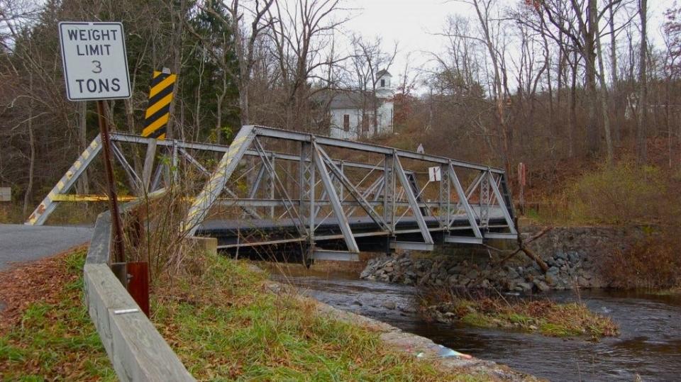
The village of Walpack Center, along with the bridge - built in 1889 - are on the National Register as the Walpack Center Historic District. The historic village was central to the homesteads and farms which made up the valley through which the Flatbrook flows.
According to the park, the bridge is one of only two truss bridges in Sussex County built by Groton Bridge & Manufacturing Company of Groton, New York.
With the closing of the Main Street bridge, the nearest crossings of the creek are County Route 560 which crosses the creek east of Layton; and to the south, where Old Mine Road meets with NPS Route 615 at Flatbrookville.
The roads at the cemetery lead south to Buttermilk Falls, the tallest waterfall in New Jersey; north along the brook to County Route 560; and east toward U.S. Route 206.
This article originally appeared on New Jersey Herald: Walpack bridge closes due to hit-and-run crash

