Flood and avalanche risks are high as potent Pacific moisture hits B.C.
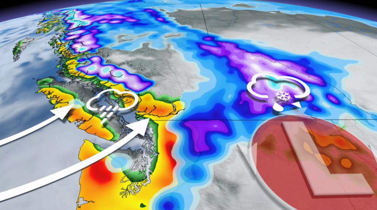
An atmospheric river is bringing significant amounts of rain to the South Coast of British Columbia, with Vancouver reporting its wettest day of the year so far on Monday.
A flood and landslide risk persists, while a high avalanche danger builds on Vancouver Island and the North Shore Mountains. More than 10 hours of freezing rain is possible in the Interior, as well.
WINTER 2024: El Niño will play a critical role in the weeks ahead
While this particular atmospheric river is only rated between AR1 to AR2, heavy rainfall rates and soaring freezing levels have combined to produce a localized flood threat for many areas, and an avalanche risk will exist in the alpine regions as warm temperatures and the rain destabilize the fresh snowpack.
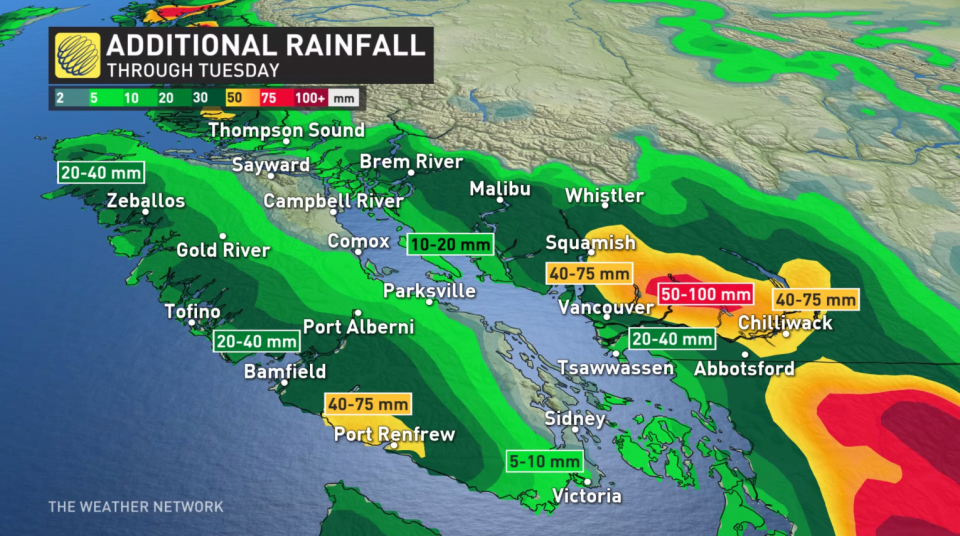
Tuesday: Heaviest rain eases for coastal sections, Vancouver Island
With some additional rainfall amounts expected Tuesday, this storm will gradually weaken for coastal sections on Tuesday. So far, nearly 50 mm of rain was reported at Vancouver's airport, making for the wettest day on record since September 2021. This also ranks as the wettest day of the year so far for the city.

Ongoing showers will continue through the afternoon and evening, but places like Vancouver, Victoria and west Vancouver Island may be drier than surrounding regions due to the rain-shadow effect.
Rivers and streams will still be running higher than normal with the ongoing rain, as well as the high freezing levels adding snowmelt to the equation.
Freezing levels will slowly drop through Tuesday, closer to 1200 metres, and then drop further down to around 600 metres by the end of the week. More rounds of rain showers are expected late week and into the weekend, but appear much more disorganized and less potent than what we saw on Monday.
WATCH: Rain records broken during B.C. storm, flooding and avalanches still a risk
Interior freezing rain threat
For the Interior, the rain may freeze on contact as the chillier air holds. However, by the afternoon hours on Tuesday, a surge of warm Pacific air will change the freezing levels well above the passes, bringing rain to higher elevations.
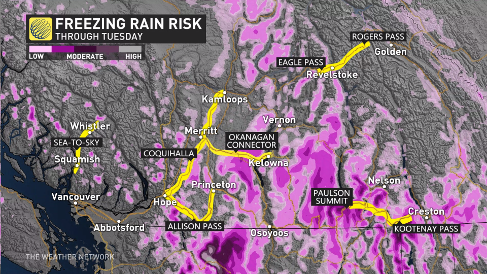
The high freezing levels will be short-lived, so it is possible that cold air will remain persistent in the valleys leading to freezing rain and drizzle that may last several hours, especially for the southern Kootenays. How much ice builds up is uncertain as freezing levels will be quite changeable Tuesday.
Wednesday: More impactful weather with ongoing Pacific moisture
Freezing levels drop mid-to-late week, allowing for snow to fall once again across the Kootenays and Rockies.
Between 30-50+cm of snow is expected on the alpines, as a stateside low forms and moves over the interior mountains.
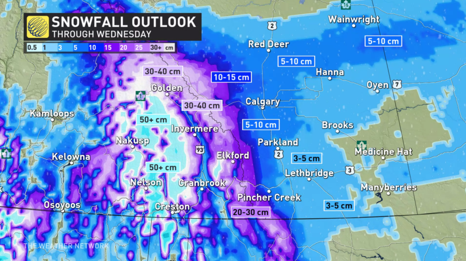
The very changeable weather has led to a 'high' avalanche danger, with increased snowpack instability.
Folks across the region should diligently check avalanche ratings and take appropriate safety measures, staying on top of the ever-present avalanche risk across the province’s terrain.

Stay with The Weather Network for the latest on conditions across B.C.

