Flood emergencies force evacuations and water rescues across the South
Life-threatening flash flooding forced evacuations and water rescues across parts of the South Friday morning.
Some of the worst flooding centered on portions of western Kentucky and Tennessee, where multiple flash flood emergencies were issued Friday morning. Flash flood emergencies are a sign forecasters are confident the situation is life-threatening and are the highest level of warning the National Weather Service can issue for flooding.
The National Weather Service in Memphis used rare language to describe the risk, calling it a “particularly dangerous situation” and warning residents in places like Union City, Tennessee, to seek higher ground immediately.
Rising floodwaters there forced residents of the Green Acres Mobile Home Park, the Davy Crockett Senior Center and some area homes to evacuate, Union City officials confirmed to CNN. Nine to 11 inches of rain had fallen in parts of the area Thursday night into early Friday.
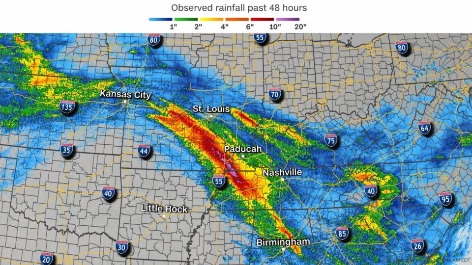
Several others were evacuated from their homes in Fulton County, Kentucky, amid a separate flash flood emergency, Fulton County Deputy Brooke Amberg told CNN. Numerous roadways were also flooded in the county after 11 inches of rain fell near Hickman, Kentucky.
Torrential rainfall also deluged northern Alabama Friday morning and the city of Oneonta, located about 30 miles northeast of Birmingham, took the brunt of it. Many of the roads in Oneonta were covered with water, with multiple roadways “dangerously flooded,” according to the Blount County Emergency Management Agency.
Four people were rescued by emergency personnel in Oneonta after drivers failed to forge flooded roadways, Brandon Horton, the city’s Director of Public Safety confirmed to CNN. Oneonta recorded more than 4 inches of rainfall in less than 3 hours which quickly set flash flooding into motion.
The prolific rainfall and flooding happened because of training storms.
Training occurs when multiple storms move over the same area one after another, similar to multiple train cars on the same track. Storms of this nature can produce massive amounts of rainfall over the same area in quick succession, rapidly increasing the threat of dangerous flooding.
Rainfall rates from these storms reached 2 to 3 inches per hour at times late Thursday night into Friday morning – enough rain to overwhelm almost any drainage system and cause flash flooding.
Heavy downpours finally let up early Friday afternoon after slamming the already-soaked areas through the late morning. Any additional rainfall into the weekend could restart flooding across parts of Kentucky and Tennessee.
CNN’s Rebekah Riess and Jennifer Henderson contributed to this story.
For more CNN news and newsletters create an account at CNN.com

