Flash flood warnings lifted in Triangle, but advisory remains in effect
The National Weather Service lifted flash flood warnings for the Triangle area Friday afternoon, leaving a lower-level flood advisory in effect in Wake, Durham, Orange, Chatham and Alamance counties until 5:15 p.m.
Areas most likely to see flooding include .Durham, Chapel Hill, Carrboro, Bethesda, Parkwood, Eno River State Park, Gorman, Research Triangle Park, Jordan Lake, Rollingview Marina and Falls Lake.
️Radar Update: Rain rates have decreased substantially over the past few hours leading to mostly light rain, with pockets of moderate rain.
All Flash Flood warnings have been cancelled, but ponding on roadways remain possible where moderate rain exists. #NCwx pic.twitter.com/lLLPnRzDZW— NWS Raleigh (@NWSRaleigh) April 7, 2023
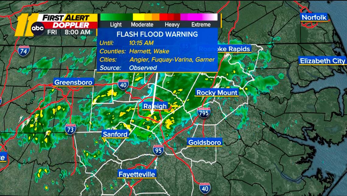
Thunderstorms with heavy rain flooded roads and parks in southern Wake County on Friday morning, and lightning sparked a townhome fire in Garner.
Residents should look out for flooding in low-lying and flood-prone locations, such as rivers, creeks and streams.
30 mph winds
The NWS warned of 30 mph winds early Friday morning, advising residents to seek seek shelter in sturdy structures.
High-speed winds are expected to affect Mebane and Roxboro until 8 p.m. Friday, the weather service reported.
Between 3 and 4 inches of rain fell across the Triangle region Friday morning, with another 1 to 2 inches possible.
Major flooding happened at Mineral Springs Park in Fuquay-Varina after rains overtook a creek in the park, media outlets reported.
Flooding in Fuquay-Varina this morning. Video from @tommeinerstv. Flash Flood Warning continues for southern Wake and northern Harnett Counties until 10:15am. #ncwx #WeatherOnThe1s @SpecNews1RDU @NWSRaleigh pic.twitter.com/eIrLzWD80r
— Lee Ringer (@LeeRingerWx) April 7, 2023
A Wake County sheriff’s deputy had to block off a road from drivers due to flooding in the town, according to ABC11. The News & Observer’s media partner.
Authorities warn that most flood deaths occur in vehicles.
“Turn around, don’t drown when encountering flooded roads” the NWS cautioned.
READ MORE: Here are Raleigh’s top flood-prone areas to avoid
Several crashes reported
Standing water on U.S. 1 near exit 99 in Cary closed three southbound lanes Friday morning, media outlets reported.
A crash before 8 a.m. on Interstate 40 eastbound near U.S. 70 by Garner closed the right shoulder of traffic, according to the Department of Transportation’s website.
A State Highway Patrol dispatcher for Wake County told The N&O that troopers responded to several crashes Friday morning.
A jeep hydroplaned and flipped on its side on Interstate 540 and knocked down a guardrail around 7 a.m., WRAL reported. No injuries were reported at the crash, which also involved at least one other vehicle.
Storm damages homes
Storms caused a tree to fall on a house in Sanford, injuring one resident, local media outlets reported.
The Sanford Fire Department said at least one person at the home in the 700 block of Third Street was injured and hospitalized with non-life-threatening injuries.
In Garner, lightning struck the roof of a townhome on Misty Pike Drive and caused a fire shortly after 7 a.m.
“The building was not sprinklered, so the fire grew,” Fire Chief Matt Poole told ABC11 Friday morning. “We’ve had multiple departments come out here and assist us, so the fire’s under control now.”
No civilians or firefighters were injured, he said.
Local weather forecast
The recent 80 degree days are gone for now.
Friday’s high temperature will reach just the upper 40s, according to ABC11.
Saturday will see more soaking rain with highs near 50.
READ MORE: Don’t drive through floodwaters + other tips for staying safe during heavy rain storms
National Weather Service warnings
Here are the different levels of caution the NWS uses, according to the agency’s website:
Flood Watch: Be Prepared: A Flood Watch is issued when conditions are favorable for a specific hazardous weather event to occur. A Flood Watch is issued when conditions are favorable for flooding. It does not mean flooding will occur, but it is possible.
Flood Advisory: Be Aware: A Flood Advisory is issued when a specific weather event that is forecast to occur may become a nuisance. A Flood Advisory is issued when flooding is not expected to be bad enough to issue a warning. However, it may cause significant inconvenience, and if caution is not exercised, it could lead to situations that may threaten life and/or property.
Flash Flood Warning: Take Action! A Flash Flood Warning is issued when a flash flood is imminent or occurring. If you are in a flood prone area move immediately to high ground. A flash flood is a sudden violent flood that can take from minutes to hours to develop. It is even possible to experience a flash flood in areas not immediately receiving rain.
Flood Warning: Take Action! A Flood Warning is issued when the hazardous weather event is imminent or already happening. A Flood Warning is issued when flooding is imminent or occurring.
Don’t drive through floodwaters + other tips for staying safe during heavy rain storms

