Flood watches, high wind warnings issued as Hilary's remnants eke past Utah
Several flood and high wind advisories remain in effect throughout Utah most of Monday as the remnants of Hurricane Hilary move through parts of Utah after the tropical storm made landfall in Mexico and California on Sunday.
The National Weather Service issued a flood watch for most of southwest and south-central Utah, which will remain in effect through Monday evening. It advises that rivers, creeks, streams, slot canyons, dry washes, recent wildfire burn scars and "other low-lying and flood-prone locations" are most at risk by rainfall forecast Monday.
The agency may elevate localized areas into flood advisories and flood warnings throughout the day based on what materializes.
It also issued a high wind warning for most of western Utah that remains in effect through 3 p.m. in southern Utah and 9 p.m. in northern Utah, where sustained winds of 25 to 40 mph and gusts up to 60 mph are forecast in areas like Cedar City, Delta and Tooele and Wendover. Meteorologists issued a wind advisory for Brigham City and Snowville, where gusts may reach 50 mph, as well.
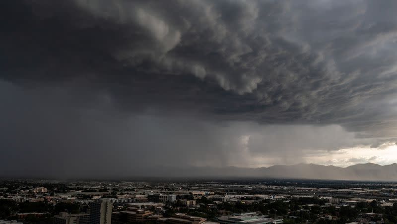
The advisories were issued as what's left of Hurricane Hilary, now a subtropical low-pressure system through the West, where flood watches and warnings, and other weather advisories remain in place throughout parts of California, Nevada, Idaho, Oregon and Washington. The storm has already caused widespread flooding where it made landfall.
Utah is not expected to be as impacted because most of the system remains west of the Beehive State, says KSL meteorologist Matt Johnson. But scattered showers and thunderstorms are expected throughout the day, especially in the state's western half, which could bring some localized flooding.
"We are picking up a nice little tap of moisture. Showers (and) thunderstorms are expected later (Monday) but not the widespread flooding we've seen in Southern California," he said. "But the chance for storms can bring brief heavy rainfall, microburst winds and maybe even some frequent lightning."
There is an increased risk of flash flooding for southern Utah National Parks and recreation areas. Make sure to check in with local visitor centers or ranger stations before heading out and have a plan if threatening weather approaches. More at: https://t.co/7kgSJIR7mF #utwx pic.twitter.com/Oq5Z2d31sL
— NWS Salt Lake City (@NWSSaltLakeCity) August 21, 2023
Scattered showers and thunderstorms are forecast to be more widespread on Tuesday, as surplus water vapor lingers.
While Utah may not be as impacted as other Western states, Rocky Mountain Power officials said Sunday that they are prepared for any damage to utilities caused by the hurricane's remnants. They said the company has crews "ready to respond to restoration efforts" to any weather-related outages.
"As a reminder, treat all downed wires as live and dangerous. Customers should avoid both downed trees and powerlines as well as keep pets far away from those areas," officials said in a statement. "It is important for all customers to report power outages as it assists crews in pinpointing the cause and facilitates restoration efforts. Customers can call customer care at 877-508-5088."
Scattered showers and storms are also in the forecast through most of the remaining workweek as a part of the active monsoonal pattern remains in place. Full seven-day forecasts for areas across Utah can be found online via the KSL Weather Center.

