Flood, wind advisories issued for San Diego as winter storm arrives

SAN DIEGO — Multiple inclement weather advisories were issued by the National Weather Service for San Diego County as residents braced for another powerful winter storm.
The fast-moving Pacific storm arrived overnight Thursday, bringing heavy rainfall, cold temperatures and strong winds to the region.
According to NWS, the biggest impact of the storm will be the downpour, with areas west of the mountains projected to see about one to two inches of rain through Friday. Mountain areas could see about two to four inches, while desert communities will likely get under an inch.
San Diego urging residents to take these steps to reduce flood risk in storm
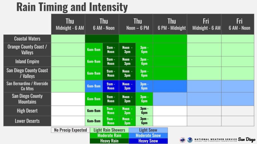
Precipitation rates could range from about 0.75 inches per hour to one-inch per hour, with the heaviest bouts of rain expected mid-day Thursday. This intensity will fall under the peak rates seen during last week’s storm of about two to three inches per hour.
Forecasters say urban flooding is very likely with this storm, especially given the intensity of the rain and existing saturation of water in the ground from last week’s rainfall. Waterways like the San Diego and Santa Margarita rivers are also expected to swell, contributing to flooding.
A flood watch will be in effect across the county until 10 a.m. Friday, indicating an elevated risk of flash flooding. The NWS “watch” advisory is the step below a “warning,” which is used to signal an imminent, dangerous impact of a weather event.
A flash flood warning has been issued for several communities in North County, including Carlsbad, Oceanside, Vista, Encinitas, Poway, Ramona, Del Mar and Fallbrook. A map of the warning area can be found below.
The warning will remain in place until 1:45 p.m. “Life-threatening” flooding may be possible in creeks and streams, urban areas, highways, streets and underpasses during this time.
The flood watch was also upgraded to a warning by NWS through 6 p.m. Thursday for the area around the San Diego River in Fashion Valley. “Minor flooding” is possible as the river is expected to crest at 10.3 feet, forecasters said.
An additional advisory for expected flooding were issued for coastal and southern areas of the county from San Diego to Imperial Beach, as the strongest band of the storm began to roll towards the region Thursday afternoon. It is set to expire at 2:30 p.m.
An outlook for the timing and intensity of rainfall with the upcoming storm through Friday afternoon can be found below.
Anticipating this flooding, the City of San Diego placed residents in the neighborhoods hardest hit by last week’s storm — such as Encanto, Mountain View, Southcrest and Chollas Creek — under a voluntary evacuation warning.
In a press conference on Wednesday, city officials encouraged residents in these areas to relocate to an emergency shelter ahead of time or ready a “go-bag” with important items, in case the evacuation warning gets upgraded to an order.
San Diego Fire-Rescue Department will also have swift water rescue teams deployed near these historically flood-prone areas for quick response.
What else is headed to San Diego with the storm?
Outside heavy rainfall, forecasters say San Diegans should also expect strong winds, particularly in coastal and inland areas, and colder temperatures.
A High Wind Watch will be in effect until 4 p.m. Thursday. During this time, southern winds are expected to sustain speeds around 20 to 30 miles per hour with gusts of 40 to 50 miles per hour, according to NWS.
Cold temperatures will cause snow levels to plummet to around 4,000 to 5,000 feet from around 6,500 feet Thursday afternoon, meaning about an inch of snow is possible for lower-elevation mountain areas in San Diego County.
Meanwhile, San Diego’s highest peaks, like Palomar Mountain and Mt. Laguna, could see around considerable snow through Friday, with amounts ranging from about two to three inches.
A Winter Storm Warning has been issued for mountain areas outside San Diego County in San Bernardino and Riverside counties. The warning will remain in effect until 6 a.m. on Friday. A Winter Storm Watch will continue until 4 p.m. Friday.
Relocating San Diego’s homeless ahead of more rain
Under the advisories, people are advised to stay off mountain roads or drive with snow chains on hand, due to conditions described as “difficult to impossible” to travel in.
How can I prepare for the storm?
City officials are urging people to be proactive in following the storm as it hits, especially those that live in low-lying or historically flood-prone areas.
Residents are encouraged to take steps like ensuring nearby storm drains are unobstructed by trash or debris, mapping safe routes to and from one’s home, packing an emergency “go-bag” or lining sandbags to divert any floodwater.
Local officials also suggest San Diegans sign up for the county’s emergency notification system.
For the latest news, weather, sports, and streaming video, head to FOX 5 San Diego & KUSI News.


