Flooding, severe weather among risks from Florida to Carolinas


AccuWeather meteorologists are closely scrutinizing a storm that is expected to form in the Gulf of Mexico and dump copious amounts of tropical moisture into the southeastern corner of the United States this weekend.
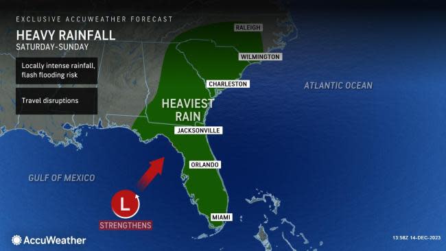
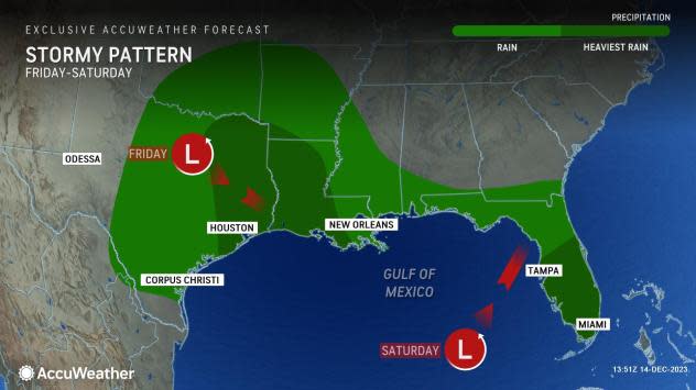
Mother Nature will put a damper on outdoor plans for residents, vacationers and snowbirds alike as the risk of heavy rain and severe thunderstorms increases across Florida during Saturday and Saturday night. During this timeframe, a slow-moving storm that produced snow and slippery travel across Colorado and New Mexico at midweek will combine with another system in the Gulf of Mexico to create the mid-December soaker.
 |
There is a slight chance that the system briefly evolves into a subtropical storm prior to moving inland in Florida early this weekend. AccuWeather forecasters say that rain, wind and hazardous beach conditions are likely up and down the Eastern Seaboard.
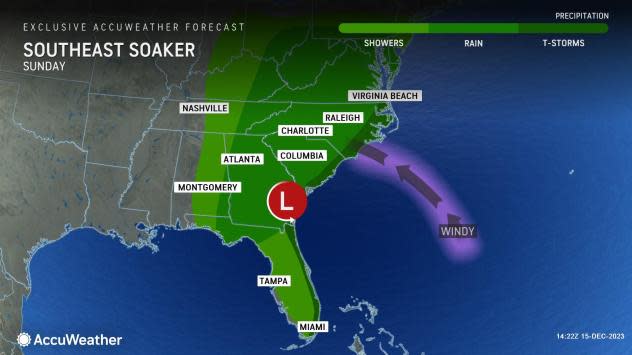
"After gathering steam from the warm waters of the Gulf of Mexico early this weekend, the storm will rocket up the Eastern states on Sunday and Monday along a path that is typical of storms during the winter months but carrying an amount of moisture usually seen during the summer," AccuWeather Senior Meteorologist Bill Deger said.
As a result of a direct feed of tropical moisture into the storm, heavy rain is expected to be a widespread concern along its path.
"The zone of heaviest rain will depend on the path of the storm, which is not yet set in stone," AccuWeather Senior Meteorologist Adam Douty explained.
 |
"If the storm tracks farther to the north and west across the Southeast, the heaviest rain is possible from the Florida Panhandle into Georgia and South Carolina. If the storm tracks closer to the Southeast coast, the heaviest rain can cross the Florida Peninsula and potentially brush the eastern Carolinas or even move offshore," Douty explained.
Motorists along stretches of interstates 4, 10, 75, 85 and 95 should sometimes expect poor driving conditions, with ponding of water on the roadways and reduced visibility from blowing spray. Flooding concerns are likely to be highest in low-lying and poor drainage areas.
 |
In total, 2-4 inches of rain can fall from much of the Sunshine State to the central Appalachians and into New England, with a swath of 4-8 inches expected along part of the southern Atlantic Seaboard. The AccuWeather Local StormMax™ is 10 inches.
Rainfall is generally not needed in this zone, but there are areas of drought that can benefit from a thorough soaking across northern Georgia, western Tennessee, the western Carolinas and western Virginia.
By Sunday, drier but windy weather is anticipated for much of the Florida Peninsula as the bulk of the rain shifts northward with the storm.
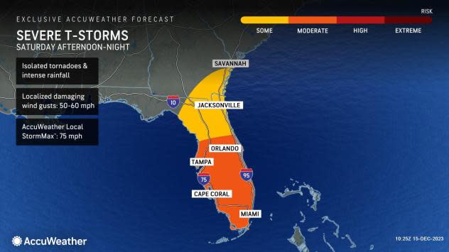
"The severe weather threat expected across Florida will be similar to that from a tropical system. This means that there will be the threat of isolated and brief tornadoes that could form with little warning Saturday through Saturday night," Douty said.
Waterspouts can also form and move inland along mainly southern portions of Florida.
 |
"The threat of tornadoes may end up being the highest Saturday night, which could be a particularly dangerous situation," Douty said.
Ahead of severe weather threats, people are encouraged to make sure they have a way to receive potentially life-saving weather alerts at night, such as downloading the free AccuWeather app and keeping a weather radio handy.
 |
By Sunday, the coastal Carolinas will be at risk of a few spin-up tornadoes as the track of the storm shifts farther to the north over the Southeastern states.
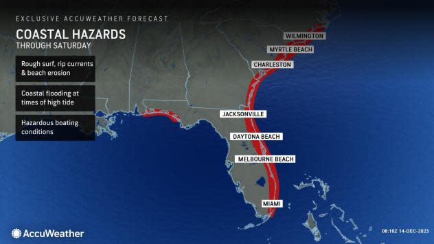
Persistent winds from the ocean have resulted in rough beach and boating conditions along the Southeast coast for much of this week. Coastal flooding has also been a concern along the east coast of Florida over the past several days.
In Tampa Bay, Florida, the wind has been blowing so strong from the east that bay water was pushed out to sea late this week.
AccuWeather meteorologists say that the recent coastal hazards will be compounded by the new storm that will take shape in the Gulf of Mexico.
"The persistent easterly flow from the ocean will not only cause water to pile up on southern Atlantic beaches but also lead to water backing up on the tidal rivers, including the St. Johns in Florida, the Savannah in Georgia and the Congaree in South Carolina," AccuWeather Senior Meteorologist Alex Sosnowski stated.
 |
Wind gusts over 40 mph are expected along the Southeast coast, making for a difficult trip to the beach when also factoring in the rough surf and wet weather.
Much quieter weather is expected to move into the region next week, providing good weather for outdoor and travel plans in the days leading up to Christmas.
Want next-level safety, ad-free? Unlock advanced, hyperlocal severe weather alerts when you subscribe to Premium+ on the AccuWeather app. AccuWeather Alerts™ are prompted by our expert meteorologists who monitor and analyze dangerous weather risks 24/7 to keep you and your family safer.
