Florida Big Bend under flood watch. Storms forecast to impact much of state
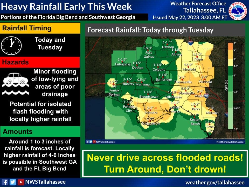
Up to 7 inches of rain could fall across some portions of Florida, according to the National Weather Service, Tallahassee.
Portions of Florida's Big Bend are under a flood watch, with 1 to 3 inches of rain in the forecast and locally higher amounts of 4 to 7 inches in the forecast.
Numerous showers and lightning storms are forecast across Central Florida later today, and could affect the East Coast by tonight, with up to 4 inches of rain expected, according to the National Weather Service, Melbourne.
Tropics watch: NHC continues to watch disturbance off Florida for potential tropical development
Category 6 hurricanes? In a warming world, 'Cat 6' hurricanes could soon be coming to a coast near you
Besides torrential rain and frequent cloud-to-ground lightning, a couple of the storms could become severe, with wind gusts approaching 60 miles per hour.
Where repeated rounds of thunderstorms occur, localized rain amounts up to 4 inches in a short time are possible, which could bring flooding of low-lying areas.
More storms are in the forecast for Central Florida during the week.
A series of disturbances will keep Central Florida unsettled for much of the week, according to the Weather Service. Copious amounts of moisture will remain in place, and weak low pressure system may form close to Florida by themiddle of the week.
As a result, numerous showers and lightning storms are in the forecast. The strongest storms will be capable ofproducing frequent cloud-to- ground lightning strikes, gusty winds from 40 to 50 mph, and hail to quarter-size.
Weather watches and warnings issued for your area
If you can't see any local weather warnings here, you'll need to open this story in a web browser.
Weather alerts issued in Florida
Weather radar and forecast for Pensacola

Monday: A 40 percent chance of showers and thunderstorms, mainly after 2 p.m. Mostly sunny, with a high near 87. North wind 5 to 10 mph becoming south in the afternoon.
Monday night: A 50 percent chance of showers and thunderstorms. Mostly cloudy, with a low around 70. Southwest wind around 5 mph becoming northeast in the evening. New rainfall amounts between a quarter and half of an inch possible.
Tuesday: A 50 percent chance of showers and thunderstorms. Partly sunny, with a high near 83. Northeast wind 5 to 10 mph. New rainfall amounts between a tenth and quarter of an inch, except higher amounts possible in thunderstorms.
Wednesday: A 20 percent chance of showers and thunderstorms after 2 p.m. Partly sunny, with a high near 78. Northeast wind 10 to 15 mph.
Follow National Weather Service Mobile on Twitter
Weather radar and forecast for Tallahassee

A flood watch is in effect from noon Monday through 2 a.m. Wednesday, according to the National Weather Service, Tallahassee.
Several rounds of heavy rainfall are possible over the next two days. Widespread rainfall totals of 1 to 3 inches areexpected with isolated totals of 4 to 7 inches possible.
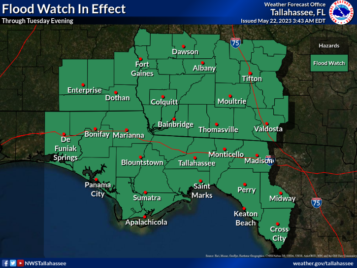
The flood watch includes the following areas: Calhoun, Central Walton, Coastal Bay, Coastal Dixie, Coastal Franklin, Coastal Gulf, Coastal Jefferson, Coastal Taylor, Coastal Wakulla, Gadsden, Holmes, Inland Bay, Inland Dixie, Inland Franklin, Inland Gulf, Inland Jefferson, Inland Taylor, Inland Wakulla, Jackson, Lafayette, Leon, Liberty, Madison, North Walton, South Walton and Washington. In Georgia, Baker, Ben Hill, Berrien, Brooks, Calhoun, Clay, Colquitt, Cook, Decatur, Dougherty, Early, Grady, Irwin, Lanier, Lee, Lowndes, Miller, Mitchell, Quitman, Randolph, Seminole, Terrell, Thomas, Tift, Turner and Worth.
Monday: Showers and thunderstorms, mainly after 2 p.m. Some of the storms could produce heavy rain. High near 82. East wind around 5 mph. Chance of precipitation is 80%. New rainfall amounts between a half and three quarters of an inch possible.
Monday night: Showers and thunderstorms, mainly before 8 p.m. Low around 68. East wind around 5 mph. Chance of precipitation is 80%. New rainfall amounts between a tenth and quarter of an inch, except higher amounts possible in thunderstorms.
Tuesday: Showers and thunderstorms. High near 78. Northeast wind 5 to 10 mph. Chance of precipitation is 80%. New rainfall amounts between a quarter and half of an inch possible.
Wednesday: A slight chance of showers and thunderstorms before 8 a.m., then a slight chance of showers between 8 a.m. and 2 p.m., then a chance of showers and thunderstorms after 2 p.m. Mostly cloudy, with a high near 78. Northeast wind 10 to 15 mph. Chance of precipitation is 40%.
Follow the National Weather Service Tallahassee on Twitter
Weather radar and forecast for Jacksonville
Monday: Showers and thunderstorms likely before noon, then showers and possibly a thunderstorm between noon and 2 p.m., then showers and thunderstorms after 2 p.m. High near 80. East wind 5 to 10 mph. Chance of precipitation is 80%. New rainfall amounts between a quarter and half of an inch possible.
Monday night: Showers and thunderstorms before 8 p.m., then showers likely and possibly a thunderstorm between 8 p.m. and 10 p.m., then a chance of showers and thunderstorms after 10pm. Low around 70. Northeast wind 5 to 10 mph. Chance of precipitation is 80%. New rainfall amounts between a quarter and half of an inch possible.
Tuesday: Showers and possibly a thunderstorm. High near 79. Northeast wind 6 to 11 mph. Chance of precipitation is 90%. New rainfall amounts between three quarters and one inch possible.
Wednesday: A chance of showers and thunderstorms, then showers likely and possibly a thunderstorm after 8 a.m. Mostly cloudy, with a high near 78. Northeast wind 8 to 14 mph. Chance of precipitation is 70%.
Follow the National Weather Service Jacksonville on Twitter
Weather radar and forecast for Daytona Beach
Monday: A chance of showers and thunderstorms, then showers likely and possibly a thunderstorm after 2 p.m. Some of the storms could produce gusty winds and heavy rain. Partly sunny, with a high near 83. Southeast wind 5 to 10 mph becoming northeast in the morning. Chance of precipitation is 70%. New rainfall amounts between a tenth and quarter of an inch, except higher amounts possible in thunderstorms.
Monday night: Showers likely and possibly a thunderstorm before 8 p.m., then a chance of showers and thunderstorms after 8 p.m. Mostly cloudy, with a low around 70. East northeast wind around 5 mph. Chance of precipitation is 60%. New rainfall amounts of less than a tenth of an inch, except higher amounts possible in thunderstorms.
Tuesday: Showers and possibly a thunderstorm. High near 81. East northeast wind 5 to 10 mph. Chance of precipitation is 80%. New rainfall amounts between a quarter and half of an inch possible.
Wednesday: A chance of showers and thunderstorms, then showers and possibly a thunderstorm after noon. High near 79. North northeast wind 5 to 10 mph. Chance of precipitation is 80%.
Follow the National Weather Service Melbourne on Twitter
Weather radar and forecast for Melbourne
Monday: A chance of showers and thunderstorms, then showers likely and possibly a thunderstorm after 5 p.m. Mostly sunny, with a high near 85. Light northeast wind becoming east 5 to 10 mph in the morning. Chance of precipitation is 60%. New rainfall amounts between a quarter and half of an inch possible.
Monday night: Showers and thunderstorms likely before 2 a.m., then a slight chance of showers after 5 a.m. Mostly cloudy, with a low around 72. East northeast wind 5 to 10 mph becoming southeast after midnight. Chance of precipitation is 60%. New rainfall amounts between a quarter and half of an inch possible.
Tuesday: A chance of showers and thunderstorms, then showers and possibly a thunderstorm after 2 p.m. High near 83. North wind 5 to 10 mph becoming east in the afternoon. Chance of precipitation is 80%. New rainfall amounts between a tenth and quarter of an inch, except higher amounts possible in thunderstorms.
Wednesday: A chance of showers and thunderstorms, then showers and possibly a thunderstorm after noon. High near 83. West northwest wind 5 to 10 mph becoming north northeast in the afternoon. Chance of precipitation is 80%.
Follow the National Weather Service Melbourne on Twitter
Weather radar and forecast for Port St. Lucie
Monday: A slight chance of showers and thunderstorms between 2 p.m. and 5 p.m., then showers likely and possibly a thunderstorm after 5 p.m. Mostly sunny, with a high near 88. Light north northeast wind becoming east northeast 5 to 10 mph in the morning. Chance of precipitation is 60%. New rainfall amounts of less than a tenth of an inch, except higher amounts possible in thunderstorms.
Monday night: Showers likely and possibly a thunderstorm before 11 p.m., then a chance of showers and thunderstorms between 11 p.m. and 2 a.m. Mostly cloudy, with a low around 71. East northeast wind 5 to 10 mph. Chance of precipitation is 60%. New rainfall amounts of less than a tenth of an inch, except higher amounts possible in thunderstorms.
Tuesday: A chance of showers and thunderstorms between 8 a.m. and 2 p.m., then showers and possibly a thunderstorm after 2 p.m. High near 86. East northeast wind 5 to 10 mph becoming south in the morning. Chance of precipitation is 80%. New rainfall amounts between a tenth and quarter of an inch, except higher amounts possible in thunderstorms.
Wednesday: A chance of showers and thunderstorms, then showers and possibly a thunderstorm after noon. High near 86. West wind 5 to 10 mph becoming north in the afternoon. Chance of precipitation is 80%.
Follow the National Weather Service Melbourne on Twitter
Weather radar and forecast for West Palm Beach

Numerous thunderstorms are likely over interior and eastern portions of South Florida this afternoon and evening. A few of these may become strong, especially around the Lake region, according to the National Weather Service Miami.
Heavy rainfall within showers and thunderstorms could lead to localized flooding across portions of the east coast metro areas. Showers and storms will become fairly widespread this week. Pockets of heavy rain will be possible.
Monday: A 30 percent chance of showers and thunderstorms, mainly after 5 p.m. Mostly sunny, with a high near 82. East wind 6 to 14 mph.
Monday night: A 40 percent chance of showers and thunderstorms, mainly before midnight. Mostly cloudy, with a low around 78. East wind 5 to 14 mph.
Tuesday: A chance of showers and thunderstorms, then showers and possibly a thunderstorm after 2 p.m. High near 82. Southeast wind 5 to 10 mph becoming southwest in the morning. Chance of precipitation is 80%. New rainfall amounts between a tenth and quarter of an inch, except higher amounts possible in thunderstorms.
Wednesday: A chance of showers and thunderstorms, then showers and possibly a thunderstorm after 8 a.m. High near 82. Southwest wind 6 to 11 mph becoming south in the afternoon. Chance of precipitation is 90%.
Follow the National Weather Service Miami on Twitter
Weather radar and forecast for Naples
Monday: A slight chance of showers, then a chance of showers and thunderstorms after 11 a.m. Mostly sunny, with a high near 87. East wind 5 to 10 mph becoming west in the afternoon. Chance of precipitation is 50%. New rainfall amounts of less than a tenth of an inch, except higher amounts possible in thunderstorms.
Monday night: Showers likely and possibly a thunderstorm before 7 p.m., then a chance of showers and thunderstorms between 7 p.m. and 1 a.m. Partly cloudy, with a low around 73. Northwest wind around 7 mph becoming southeast after midnight. Chance of precipitation is 60%. New rainfall amounts of less than a tenth of an inch, except higher amounts possible in thunderstorms.
Tuesday: A chance of showers and thunderstorms, then showers likely and possibly a thunderstorm after 2 p.m. Mostly sunny, with a high near 86. East wind 5 to 11 mph becoming west in the afternoon. Chance of precipitation is 60%. New rainfall amounts of less than a tenth of an inch, except higher amounts possible in thunderstorms.
Wednesday: A chance of showers and thunderstorms, then showers likely and possibly a thunderstorm after 2 p.m. Mostly sunny, with a high near 86. West wind 6 to 11 mph. Chance of precipitation is 60%.
Follow the National Weather Service Miami on Twitter
Weather radar and forecast for Fort Myers

Monday: Showers and thunderstorms likely, mainly before 4 p.m., then showers likely and possibly a thunderstorm after 5 p.m. Mostly sunny, with a high near 89. Heat index values as high as 97. Light and variable wind becoming west around 6 mph in the afternoon. Chance of precipitation is 60%. New rainfall amounts between a quarter and half of an inch possible.
Monday night: Scattered showers and thunderstorms, mainly before 10 p.m. Partly cloudy, with a low around 73. North northwest wind around 7 mph becoming east southeast after midnight. Chance of precipitation is 40%.
Tuesday: Scattered showers, with thunderstorms also possible after 11 a.m. Mostly sunny, with a high near 88. East wind 5 to 9 mph becoming west in the morning. Chance of precipitation is 40%.
Wednesday: Scattered showers before 11 a.m., then scattered showers and thunderstorms between 11 a.m. and 2 p.m., then showers likely and possibly a thunderstorm after 2 p.m. Mostly sunny, with a high near 86. North wind 5 to 10 mph becoming west in the afternoon. Chance of precipitation is 60%.
Follow the National Weather Service Tampa Bay on Twitter
Weather radar and forecast for Sarasota
Today: Scattered showers and thunderstorms, mainly after noon. Sunny, with a high near 90. Heat index values as high as 101. East wind 5 to 10 mph becoming west in the afternoon. Chance of precipitation is 40%.
Tonight: Scattered showers and thunderstorms, mainly before 10 p.m. Partly cloudy, with a low around 72. North wind 7 to 9 mph becoming east southeast after midnight. Chance of precipitation is 40%.
Tuesday: Scattered showers, with thunderstorms also possible after 11 a.m. Mostly sunny, with a high near 88. East wind 5 to 11 mph becoming west in the afternoon. Chance of precipitation is 30%.
Wednesday: Scattered showers before 11 a.m., then scattered showers and thunderstorms between 11 a.m. and 2 p.m., then showers likely and possibly a thunderstorm after 2 p.m. Mostly sunny, with a high near 86. North northeast wind 6 to 11 mph becoming west in the afternoon. Chance of precipitation is 60%.
Follow the National Weather Service Tampa Bay on Twitter
This article originally appeared on Treasure Coast Newspapers: Florida weather forecast: Heavy rain, strong wind, possible hail

