When will Florida feel the worst weather from Hurricane Idalia? See times for each area
Florida is feeling Hurricane Idalia’s gusty winds and rain as the storm treks closer to the state.
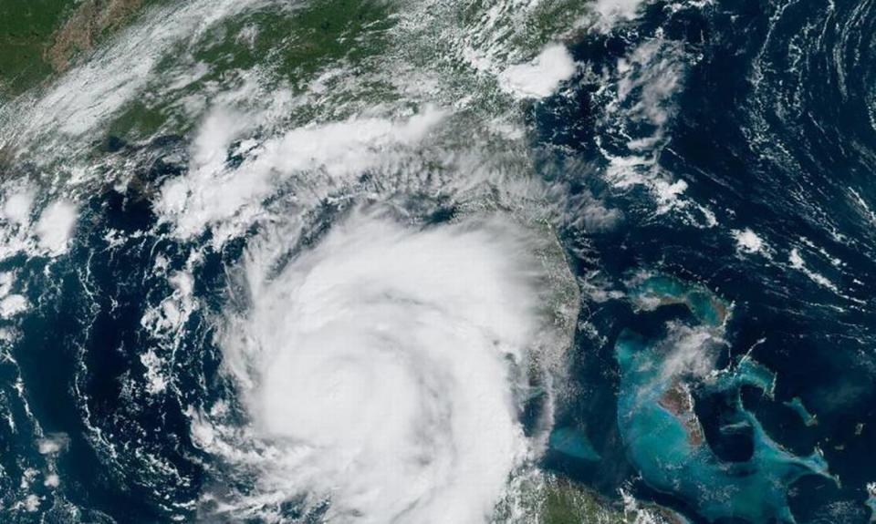
The National Hurricane Center predicts Idalia will strengthen into a Category 4 storm before making landfall Wednesday on Florida’s west coast, likely in the Big Bend area. And while Idalia’s impact will be felt far from the center, generally speaking, the worst weather will typically occur on the storm’s “dirty side.”
But no matter where you are in the state, expect Idalia to bring some gloomy and nasty weather — rain, strong winds, some tornadoes, and life-threatening storm surge along the west coast.
Here’s the forecast by region:
South Florida
There’s good news for South Florida: While Idalia will bring some stormy weather to the region, it won’t be too bad.
For Miami-Dade, Broward and Palm Beach counties, the worst weather was felt Tuesday afternoon through the night as Idalia’s outer bands approached the region from the west, according to Sammy Hadi, a meteorologist for the National Weather Service in Miami.
What to expect: heavy rain, thunderstorms, some possible isolated tornadoes and winds between 10 to 25 mph, Hadi said. And while South Florida won’t see sustained tropical storm force winds, gusts of more than 40 mph will be possible and a few tornado warnings may be issued, he said.
Nearly all of Miami-Dade was under a severe thunderstorm warning until 5:30 p.m. Tuesday. Forecasters reported 55 to 65 mph winds in the south parts of the county.
Severe Thunderstorm Warning including Miami FL, Hialeah FL and Miami Gardens FL until 5:30 PM EDT. This storm will contain wind gusts to 70 MPH! pic.twitter.com/htyDjmgXlo
— NWS Miami (@NWSMiami) August 29, 2023
The highest gusts will likely happen on Wednesday, according to the weather service’s hazardous weather outlook.
Here’s how much rain to expect:
The forecast is calling for a 70% chance of rain Tuesday night in Miami-Dade and a 60% chance of rain in Broward, with new rainfall amounts between a tenth and quarter of an inch, with higher amounts possible during thunderstorms. In Palm Beach County, there’s a 50% chance of rain Tuesday night.
On Wednesday, which is when Idalia is forecast to make landfall on Florida’s Gulf Coast, South Florida will likely just feel its trail of moisture from the far-off storm, Hadi said.
The forecast is calling for an 80% chance of rain Wednesday in Miami-Dade and 70% chance of rain in Broward, with new rainfall amounts between a tenth and quarter of an inch, with higher amounts possible in thunderstorms. The rain chances drop to 50% Wednesday night in Miami-Dade and 40% in Broward. Palm Beach County has a 70% chance of rain, with new rainfall amounts between a half and three quarters of an inch possible.
The Florida Keys
Idalia’s squalls spread over portions of the Lower Keys, which are under a tropical storm watch. The worst weather will likely occur Tuesday through mid-day Wednesday, according to the Keys weather service.
NWS Keys Meteorologist Nancy Barnhardt said squalls between 40 to 60 mph have been recorded so far in the Keys, with one to two inches of rain possible, with coastal flooding expected to continue.
Here is a preliminary look at the winds observed across the Florida Keys after the first rainband passage across the Lower Keys. Peak gusts were observed offshore at Sand Key. Please use caution this afternoon through Wednesday when driving due to windy and squally conditions. pic.twitter.com/XSaXpUs4o9
— NWS Key West (@NWSKeyWest) August 29, 2023
Key West, for example, is forecast to see 70% chance of rain Tuesday night and Wednesday. Gusts could be as high as 30 mph Tuesday night, and 20 mph on Wednesday.
The Florida Keys could see 1 to 2 feet of storm surge above ground if the peak surge occurs at the time of high tide, according to the National Hurricane Center. A coastal flood warning is in effect until at least 2 p.m. Wednesday in the Lower Keys.
“The combination of king tides and strong southerly breezes, will result in coastal flooding across the Lower Keys, but especially the vulnerable Atlantic side neighborhoods of Key West,” according to the Keys hazardous weather outlook. “Peak water levels will reach a little over 2 feet above mean high tide. Observations from the vulnerable neighborhoods of Key West this morning confirm these peak water levels.”
“Take the necessary actions to protect flood-prone property. If travel is required, do not drive around barricades or throughwater of unknown depth,” the weather service states.
North Florida
According to Mark Wool, the warning coordination meteorologist at the Tallahassee office of the National Weather Service, North Florida will start to feel effects as early as 4 a.m. Wednesday.
Sustained tropical storm force winds are likely to start closer to 7 a.m. Wednesday, but Wool stressed that residents should be 100% prepared by the time they go to bed Tuesday night in case the effects start earlier in the morning.
Those who need to evacuate homes should do so before they go to bed Tuesday night. The worst of the storm will likely come in the daylight hours of the morning and into the early afternoon, Wool said.
The coast around Apalachee Bay will be hit with severe, life-threatening storm surges. Coastal areas to the southeast of the Aucilla River will likely see 10 to 15 feet of storm surge. The other side of the Aucilla River, including the coastal areas directly south of Tallahassee, will see 6 to 9 feet of flooding.
A hurricane warning, which means that hurricane conditions are expected in the area, is in place in areas from the middle of Longboat Key northward to Indian Pass.
The weather should start improving in the afternoon, and conditions will likely be better by Wednesday night.
However, this doesn’t mean that it’s safe to go outside. Even after winds subside, there will be downed wires, fallen trees and utility crews in the streets.
Residents should be prepared to shelter in place until officials inform them that it’s safe, and should expect power outages.
Northeast Florida
The worst of the storm will likely hit Northeast Florida around 10 a.m. Wednesday, said Danny DuBois, a meteorologist at the National Weather Center office in Jacksonville.
Residents of northeastern Florida should have already finished their preparations.
Those in the area will likely start feeling tropical storm force winds around 2 to 3 a.m. Wednesday.
The areas to the west of Jacksonville will see around 4-8 inches of rain, according to DuBois. The Jacksonville area will see 1.5 to 2 inches, while the coast will see 1 to 1.5 inches.
The flooding will likely not be major, but the winds are expected to be strong.
Improvements should come 7 to 8 p.m. Wednesday in the Jacksonville area.
![Edna Ramirez carries a shovel full sand to a bagging station as people were doing the same at the Dunnellon Public Works site on Bostick Street Tuesday morning, August 29, 2023. On Monday, Dunnellon had filled 1500 bags while on Tuesday that had given out 2500 bags by noon. [Doug Engle/Ocala Star Banner]2023](https://s.yimg.com/ny/api/res/1.2/bpTjH_VFYQDVyXDbEueElw--/YXBwaWQ9aGlnaGxhbmRlcjt3PTk2MDtoPTYyNQ--/https://media.zenfs.com/en/miami_herald_mcclatchy_975/0113508e4dff5d5601a9a57dc122e43d)
Tampa Bay
By 9 p.m. Tuesday, the Tampa Bay area should be feeling tropical storm winds, said Yidiana Zayas, a meteorologist with the National Weather Service in Tampa. But the worst effects from Idalia will happen overnight between 2 and 4 a.m. Wednesday. Tampa is about two hours south of Cedar Key, where Idalia is projected to make landfall.
“There will be about 30 to 40 mph winds with gusts up to 70 mph,” Zayas said. “If you’re closer to the coast, you should expect winds… that are more like Category 1 hurricane.”
The region is also under a flood watch, with about 4 to 8 inches of flooding rains expected. There’s also potential for life-threatening storm surge — and a threat of tornadoes.
Tampa Bay Area: Here’s a county by county look at potential storm surge. If you live west of US 19 in Citrus, Hernando & Pasco there’s a good chance you will have significant street and house flooding. In Tampa Bay there’s a chance we may have record water levels. Be safe! @WFLA pic.twitter.com/w1QFS3AtTX
— Jeff Berardelli (@WeatherProf) August 29, 2023
“Storm surge remains the same at 4 to 7 feet above ground through Thursday morning with the high tide combination,” Zayas said.
The NWS is also warning area residents of roads becoming impassable due to debris in urban or heavily wooded areas as well as scattered power outages.
The chance of rain on Wednesday is 100%. Showers and thunderstorms are expected before 3 p.m. and after 3 p.m. The weather service predicts Thursday’s weather will be about the same. By Friday the chance of rain dips to 90% and will continue decreasing later into the week.
![A man sleeps after arriving to the hurricane shelter at Vanguard High School Tuesday morning August 29, 2023 in Ocala, FL in preparation for Hurricane Idalia’s arrival. [Doug Engle/Ocala Star Banner]2023](https://s.yimg.com/ny/api/res/1.2/PBMpztCe9WwlJZNjPD__Ww--/YXBwaWQ9aGlnaGxhbmRlcjt3PTk2MDtoPTUwMw--/https://media.zenfs.com/en/miami_herald_mcclatchy_975/33ac30af4d308b6999b8fb29d615e31b)
Central Florida
Central Florida, including Orlando, should see the worst from Idalia by 2 a.m. Wednesday, said Kole Fehling, a meteorologist with the National Weather Service in Melbourne, which oversees forecasts for Orlando.
“Conditions are going to deteriorate this evening, into the night [and] tomorrow morning,” Fehling said Tuesday.

The region should expect tropical storm force-winds from 25 to 35 mph with gusts up to 45 mph. About 2 to 3 inches of rain are projected. There’s also a potential for moderate flooding rain and tornadoes.
8/29/23 11 AM | Little change to Idalia's track with the latest update. Threats to east central Florida remain the same. Conditions will start to deteriorate this afternoon, so be sure to have multiple ways of receiving weather alerts! (1/2) pic.twitter.com/nHEaNjUtkc
— NWS Melbourne (@NWSMelbourne) August 29, 2023
The weather service is also warning area residents of roads becoming impassable due to debris in urban or heavily wooded areas as well as scattered power outages.
The chance of rain on Wednesday is 80%, with possible showers and thunderstorms. Weather conditions will remain the same Thursday and Friday. Rain chances, however, will drop to 50% by Saturday.
Miami Herald Reporter Devoun Cetoute contributed to this report.

