Florida forecast: Three key factors that will determine if Gulf storm becomes a hurricane
▶UPDATED SUNDAY FORECAST: Idalia forecast: Florida faces a major hurricane threat; prepare now
A few weeks ago, a self-proclaimed “time-traveling psychic” on a platform I am not online enough to be part of declared that Florida would be hit by a “Category 6” hurricane in September. As social media views are inversely proportional to factuality, this video was seen approximately 11 billion times.
Despite the invisible upvote of The Great and Powerful Algorithm, the tropical threat Florida faces next week will not be a “Category 6” hurricane, because such a thing does not exist. However, it is increasingly likely that the state will face widespread rain, coastal flooding, and wind impacts from a tropical system crossing the eastern Gulf of Mexico between Monday and Wednesday.
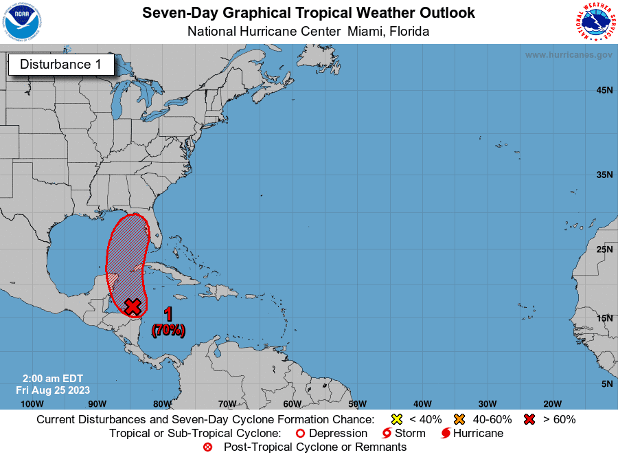
Here’s what we can say with some confidence today: first, the offending disturbance isn’t much to look at right now, so nothing will happen immediately. As of mid-day Friday, our area of interest is a diffuse region of cyclonic turning in the northwestern Caribbean Sea, punctuated by scattered, disorganized thunderstorm activity. This rotation and convection will slowly coalesce near or over the Yucatan peninsula and move little through Monday.
Tropics update: Tropical Depression 10 forms in Gulf of Mexico. It could hit Florida as Hurricane Idalia
Early next week, a potent dip in the jet stream extending from the Great Lakes into the Deep South will bring south-to-north steering currents into the Gulf. These steering winds will pick up any loitering tropical system and fling it in the direction of Florida, with inclement weather starting Tuesday and the storm itself crossing the Gulf Coast around Wednesday.
There is better agreement between leading weather models today versus earlier this week on that general scenario, and a named storm in the Gulf by Tuesday is more likely than not. Still, a broad range of outcomes is on the table in terms of potential strength of this storm and where in Florida its impacts will be most keenly felt.
There are three key considerations that will tell the tale, so let’s walk through them one-by-one.
Key consideration #1: Where will the center form and how will it track?
The greatest source of forecast uncertainty at this stage is associated with where a unified center of circulation forms over the weekend. Right now, the area of spin and embedded pockets of faster rotation extends over Central America, the Caribbean, and the southern Gulf. This is likely to condense with the help of convection into a single circulation by Sunday or Monday.
What we don’t know is whether this circulation will form over the Yucatan peninsula, the northwest Caribbean, or the far southern Gulf.
This is important, as models show the eventual track of a storm that may become Idalia is dependent on where it forms; development north and east would tilt risks toward the Florida peninsula, and a circulation farther west would favor a track toward the Panhandle.
Additionally, because tropical cyclones derive their energy from warm ocean waters, a spin up over the swampy land of the Yucatan would slow development until the circulation moves farther offshore. Time over water is going to matter a lot in how strong this thing gets, so as little of it as possible is best. If the system is already a tropical depression over water by late Sunday, odds of a hurricane are higher.
Key consideration #2: The role of dry air
While models are in good agreement on the steering currents that will be in place, there is more spread in how much mid-level dry air will affect the storm. In general, the European model has been more bullish on the potential for a stronger system, and keeps a dry airmass just west of the core of the developing circulation.
In contrast, the American model (GFS) has been washing this dry air over much of the disturbance as it moves across the Gulf of Mexico, resulting in a lopsided mess of a storm – though the most recent run keeps it away from the center. Both outcomes are plausible, and this too is linked to where the circulation actually forms. There is also the possibility of another wave of dry, continental air reaching the storm mid-week as it approaches Florida.
Key consideration #3: Gulf water temperatures
Unruly heat in the Gulf is a major wildcard. Water temperatures range from 86° to 90°F along a path from the Yucatan Channel to the Big Bend, two to five degrees warmer than normal. This heat goes deep, offering a tropical cyclone crossing the eastern Gulf a massive reservoir of potential energy to tap.
Extreme water temperatures alone cannot make a storm come to life, but if other ingredients like low wind shear and ample mid-level moisture are in place, it compresses the timeline of intensification. The one-and-a-half to two-and-a-half days this thing will have over near-90 degree waters is plenty of time to leap from a tropical depression to a formidable hurricane if the environmental stars align.
Don’t expect models to get this right as quick strengthening is not something they predict well.
An impactful hurricane is a possibility, so prepare now
While it is too soon to make a specific prediction for how this will all play out next week, Florida is in for some nasty weather in the Tuesday to Thursday timeframe.
Depending on where the center forms, how much dry air the storm pulls in, and how much time it has over water, the most likely outcomes range a from rainy, lopsided tropical storm to something more like Hurricane Hermine or even a bit stronger.
This does not look like an Ian-like situation due to limited time over water and lurking dry air.
'Remain vigilant and prepare': Tropical depression could develop in Gulf of Mexico
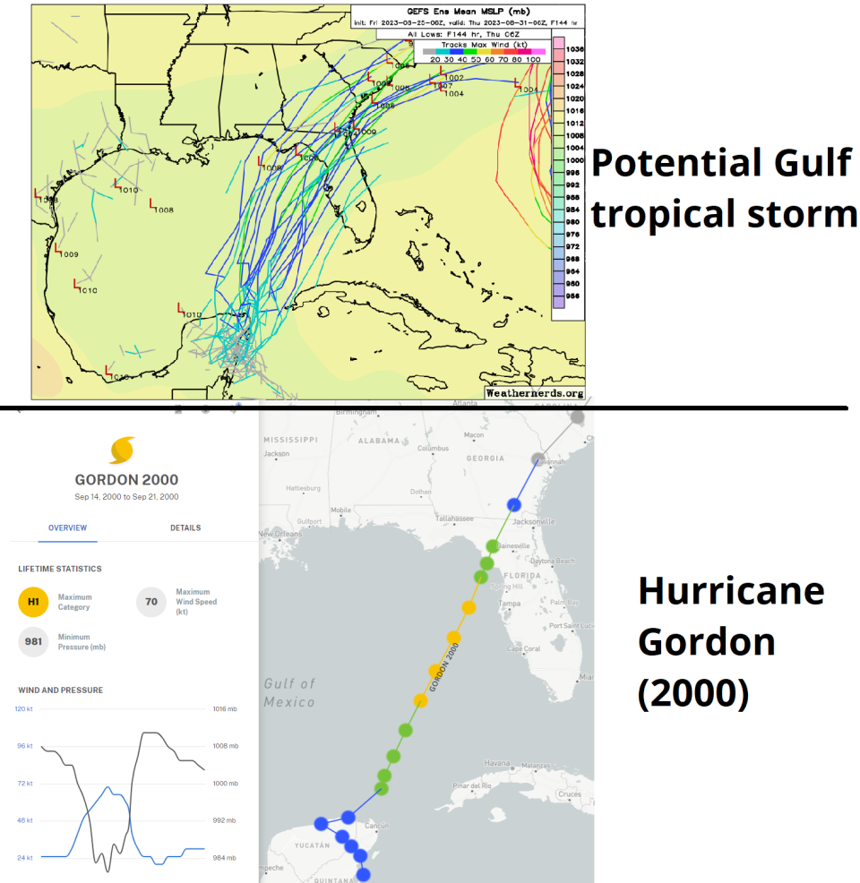
A historical storm worth considering as a rough guide is 2000’s Hurricane Gordon, which also meandered near the Yucatan and then sped northeast towards Florida’s Big Bend under a similar steering pattern. Gordon peaked as a Category 1 hurricane in the eastern Gulf, but dry air weakened it to a tropical storm by landfall.
Still, Gordon caused considerable confusion and delay along the Florida Gulf Coast, including 3- to 5-feet of surge, up to 5 inches of rain, and power outages.
In conclusion, it would be nice to time travel to see how this turns out, then check those predictions upon returning home using psychic powers.
In the real world, however, Florida is going to have to live with uncertainty for a few more days as the messy process of tropical cyclone genesis plays out. An impactful hurricane certainly is a possibility, so use the meantime to identify and plug gaps in your disaster kits. I’ll be covering this storm beginning to end, so stay tuned and keep watching the skies.

Dr. Ryan Truchelut is chief meteorologist at WeatherTiger, a Tallahassee start-up providing forensic meteorology and expert witness consulting services, and agricultural and hurricane forecasting subscriptions. Get in touch at ryan@weathertiger.com, and visit weathertiger.com for an enhanced, real-time version of our seasonal outlook.
This article originally appeared on Tallahassee Democrat: Florida hurricane tracker: System may become Tropical Storm Idalia

