Florida’s Gulf Coast braces for Cat 3 as Tropical Storm Idalia nears hurricane status
Florida could see an even stronger hurricane this week than initially predicted, bringing dangerous winds and life-threatening storm surge to much of the state’s Gulf Coast.
Tropical Storm Idalia slowly strengthened most of Monday and is expected to rapidly intensify overnight and on Tuesday as it travels north over the bathtub-warm conditions of the Gulf of Mexico.
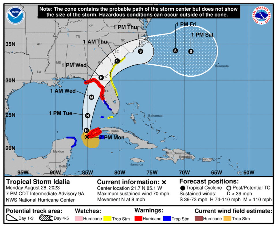
The National Hurricane Center’s 8 p.m. Monday forecast said Idalia was “almost a hurricane” near the western tip of Cuba.
The latest forecast called for the storm to hit somewhere along Florida’s Big Bend area early Wednesday as a Category 3 hurricane, bringing 120 mph sustained winds and — most dangerously — up to 12 feet of storm surge. The heavily populated Tampa Bay area could see 4 to 7 feet.
Nearly the entire Gulf Coast — along with Key West and the Lower Florida Keys — remained under hurricane, tropical storm and storm surge watches and warnings Monday evening, as well as a state of emergency declared by the governor, who directed state agencies to begin preparing for the storm over the weekend. A tropical storm watch was also issued for parts of the northeast coast of the state.
Pasco, Pinellas, Hernando, Citrus, Sarasota and Manatee counties issued mandatory evacuation orders on Monday. Tampa International Airport announced plans to close Monday afternoon, and other airports around the state might follow suit. College campuses, including the University of Florida and the University of South Florida, also announced closures.
In a Monday morning news conference, Gov. Ron DeSantis urged Floridians to prepare for the storm and protect themselves and their families.
“This is going to be a powerful hurricane and this is absolutely going to impact the state of Florida in many, many ways,” he said.
READ MORE: Did you miss the last Florida hurricane tax holiday? Here’s how to save on supplies
Tracking Idalia
After dawdling near the Yucatan Peninsula for more than a day, upper-level air currents shifted Monday, which should give Tropical Storm Idalia a push north into the Gulf of Mexico overnight into Tuesday. Sea surface temperatures in the Gulf are warmer than average, which forecasters expect will fuel Idalia into a Category 3 hurricane before it crosses Florida.
Forecasters said the storm should strengthen into a hurricane on Monday, but the system appeared to struggle a bit throughout the day, potentially giving Idalia less time to strengthen and intensify in the Gulf.
“The longer this continues, the better for Florida,” Andy Hazelton, a researcher with NOAA’s hurricane research division, posted on X, the social media site formerly known as Twitter. “How soon this happens is critical for exactly how strong Idalia becomes before landfall Wednesday.”
The Monday evening forecast called for landfall north of Horseshoe Beach, another western shift in the track. Forecasters warned that the track will continue to flip-flop east and west as the storm approaches, so anyone in a hurricane or tropical storm watch area should be prepared for a storm.
“It is still worth stressing that only a small deviation in the track could cause a significant change in Idalia’s landfall location in Florida due to the paralleling track to the west coast of the state,” forecasters warned. That was a message also delivered last year before Hurricane Ian’s wiggle to the east brought that devastating storm and deadly surge flooding into the Fort Myers area when forecast tracks days earlier had it coming ashore farther north.
If Idalia does make landfall in the Nature Coast area of the state, it would be only the second Category 3 or stronger storm to hit the area in nearly 170 years, according to Ryan Truchelut, lead meteorologist of Weather Tiger.
The hurricane center urged Floridians to not focus on exactly where the cone was pointed and to prepare for damage outside of it. The cone of uncertainty used by the hurricane center does not show where the impacts could occur; it shows a best guess at where the center of the storm could go, which means areas far outside of the cone still see destructive winds, rain and storm surge
Kevin Guthrie, director of Florida’s division of emergency management, said in a Monday morning news conference that Floridians outside the strike zone should be prepared for other impacts like tornadoes and flooding.
“If you are anywhere north of Tampa Bay to Apalachicola you will be impacted,” Guthrie said.
And it could be a very powerful storm.
The hurricane center now forecasts that Idalia will get much stronger, much faster — a process called rapid intensification. The majority of strong storms rapidly intensify just before landfall, which it now looks like Idalia will do on Tuesday.
Florida leaders said they were already preparing for the strong to strengthen even further, into a Category 4, ahead of landfall, although so far the hurricane center’s forecast only calls for a Category 3.
“I’m anticipating it is going to be a Cat 4 and we are preparing as such,” Guthrie said, noting that the state will have “more than enough resources” to respond with the help of the Florida National Guard, state and out-of-state search and rescue teams, linemen, helicopters and boats.
Based on the 5AM Monday NHC forecast advisory, here is the prep timeline for Idalia. Plan to have outdoor activities/preps wrapped up before tropical storm force winds arrive.
Any slight shifts in the track to the east/right will bring hurricane conditions to the west coast… pic.twitter.com/DTPR4r0GEc— Craig Setzer (@CraigSetzer) August 28, 2023
As of the 8 p.m. update, Idalia was about 250 miles southwest of the Florida Keys’ Dry Tortugas, with maximum sustained winds around 70 mph and headed north at 8 mph. Tropical-storm-force winds extend up to 150 miles from the center.
READ MORE: How will Tropical Storm Idalia affect South Florida weather? What the forecast says
Storm surge biggest risk
While Idalia could come ashore with 120 mph sustained winds, the biggest threat to the coast is likely to be storm surge. Coastal Taylor, Dixie, Levy and Citrus counties could see 8 to 12 feet of surge, which is water above ground level.
The Tampa Bay area could see four to seven feet of surge, a potentially record-breaking level for a region that hasn’t had a direct hurricane impact in almost a century.
Storm surge is the deadliest impact of a storm, and was the No. 1 cause of death during Hurricane Ian last year.
“Our biggest concern for Idalia is the storm surge risk along the west coast,” said Michael Brennan, director of the National Hurricane Center, in a video update Monday morning. “These are areas you do not want to be in. If you’ve been asked to evacuate by your local officials, please heed that warning.”
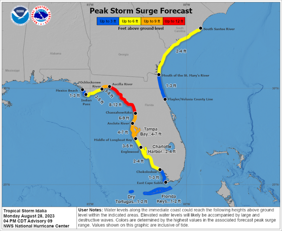
A storm surge watch, as well as a tropical storm watch, stretched from Cape San Blas in Gulf County down to the Florida Keys. The Dry Tortugas, at the very tip of the Keys, were under a tropical storm warning Monday. Some spots in the Big Bend area were upgraded to a hurricane warning.
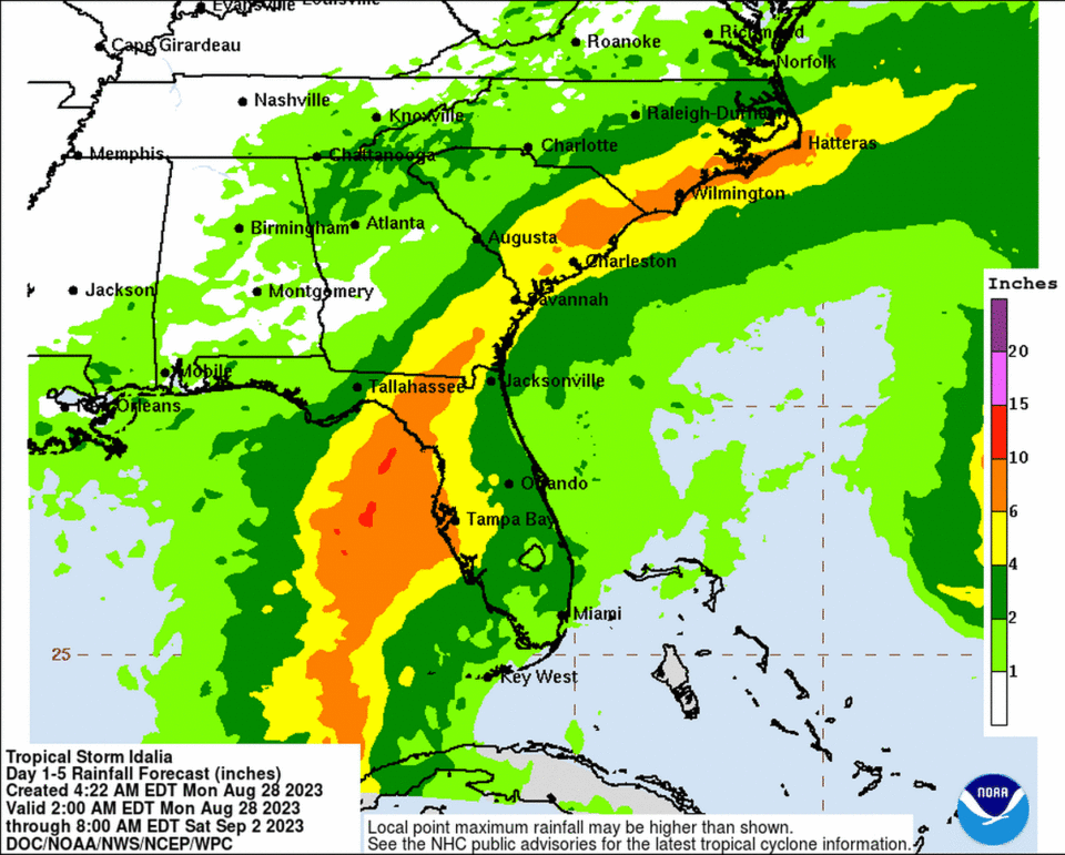
Beyond surge, Idalia is expected to douse the state with quite a bit of rain, nearly 10 inches in the Big Bend and Tampa Bay area. But flooding rain is less of a concern for this storm than it was for Hurricanes Ian or Nicole, because Idalia is expected to move quickly through the state. The latest forecast suggested Idalia would be moving at 15 mph when it makes landfall and speed up to 20 mph by the time it is near Jacksonville.
South Florida could see two to four inches of rain through Saturday. Combined with the season’s first king tide on Wednesday, the highest annual tides of the year, it could spell flooding.
The southern tip of the state could start feeling Idalia’s winds as early as Tuesday evening, but they’re expected to pick up tremendously overnight and into Wednesday as landfall approaches.
In the Keys, Monroe County officials are taking a wait-and-see approach before making any major decisions. As of Monday morning, public schools and government offices were expected to stay open as the storm is expected to pass by the island chain Tuesday and Wednesday.
“I think it’s too soon to make any decisions at this point,” Monroe County Administrator Roman Gastesi told other government officials during an Emergency Management conference call Monday morning.
Jonathan Rizzo, warning coordination meteorologist with National Weather Service Key West, said during the call that as the storm passes by the Lower Keys, some areas could expect to see tides two feet above normal, causing at least heavy street flooding in some spots, especially in Key West.
“This is not going to be insignificant,” Rizzo said.
These higher tides could be an issue as far east as Long Key, he said.
The good news for people living in areas of Key Largo — who get the worst of king tide flooding from Florida Bay in late summer and early fall — is that the winds from Idalia are coming from the south, leaving little opportunity for the system to back up water into the bay.
Hurricane Franklin and more
The hurricane center was also tracking Hurricane Franklin, which just became the first major hurricane of the season, and a disturbance in the east Atlantic with a growing chance of development.
Franklin rapidly strengthened overnight from a Category 2 storm to a Category 4 storm Monday morning with 145 mph maximum sustained winds. At 8 p.m., its sustained winds increased to 150 mph.
As a result, life-threatening surf and rip currents were occurring along the Coast of the southeast United States on Monday.
On its track, which keeps it far from the U.S. Atlantic coast, it was expected to hold this strength through the middle of the week, when it scrapes Bermuda. A tropical storm watch remained in effect for the British island territory on Monday night.
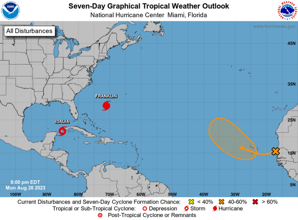
As of Monday night, a tropical wave set to roll off Africa’s west coast had a slightly higher chance of forming this week — 10% chance for the next two days and a 50% shot in the next seven.
Miami Herald/Tampa Bay Times Tallahassee Bureau staff writer Ana Ceballos and Miami Herald staff writers David Goodhue and Omar Rodríguez Ortiz contributed to this report.

