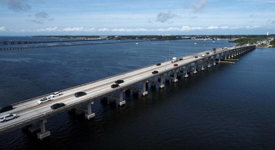
Florida plans to replace the DeSoto Bridge linking Bradenton and Palmetto. What to know
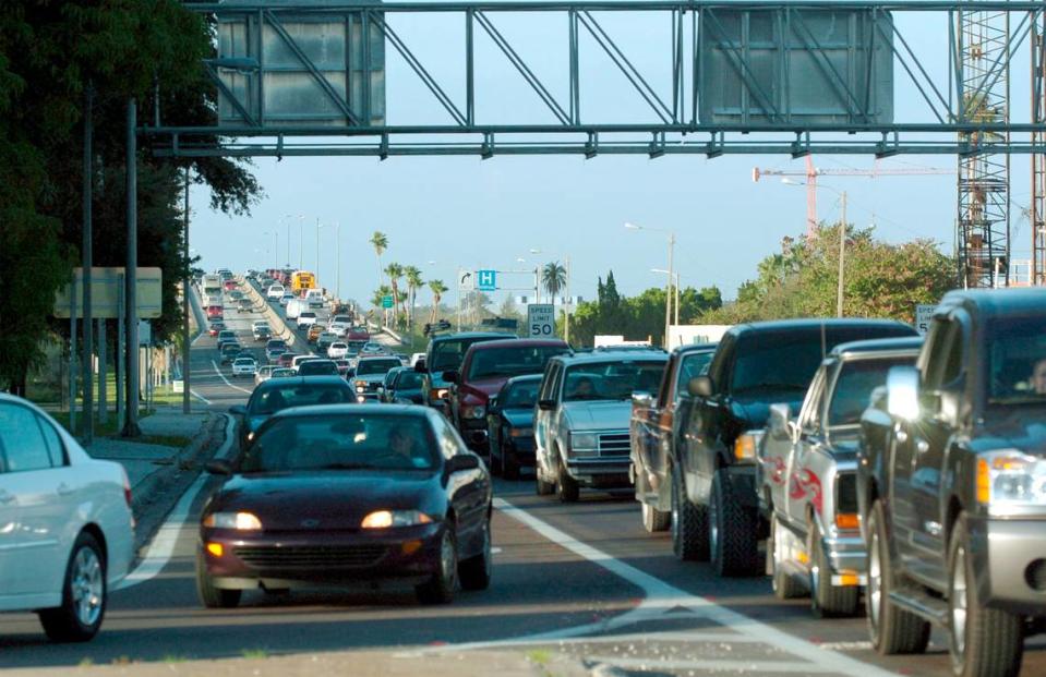
The Florida Department of Transportation has a two-part plan to alleviate traffic on the 66-year-old DeSoto Bridge between Bradenton and Palmetto.
First, FDOT plans to build a replacement bridge, starting in 2027. The three-year project is fully funded at $168 million. Still to be determined is whether the replacement bridge would be built to the east or west of the current bridge.
But what is known is that the existing bridge will will remain in service during construction.
For part two, FDOT has launched a study of 10 possible alternate corridors. One — or possibly more — could be a new bridge to share the traffic load. Some of the alternative corridors under consideration would add new bridges over the Braden River, as well as the Manatee River.
Locations for the proposed new bridges include crossings at 43rd Street West in Bradenton and the vicinity of the Interstate 75 bridge.
So far, there is no funding for the new corridors.
Why alternative corridors?
FDOT plans to replace the four-lane DeSoto Bridge with another four-lane bridge, but with new features to make it safer. The design could also potentially allow future expansion.
New features include two shoulders and a multi-use path.
“When there is a crash or a disabled vehicle on the current bridge, a lane closure is required. Similarly, traffic in both lanes must move over or slow down when non-motorized travelers utilize the current bridge.” Patricia Pichette, an FDOT communications specialist, said in an email.
“The multi-use path will separate pedestrians and cyclists from the motorized traffic, which will serve to protect the non-motorized users and remove the need to slow down or move over to accommodate them,” she said.
The shoulders could also help emergency vehicles navigate traffic.
Why build another four-lane bridge?
The existing bridge is at the end of its service life, and there is funding to replace the existing bridge with another four-lane bridge, FDOT officials say.
The Sarasota-Manatee Metropolitan Planning Organization, which establishes priorities for area transportation projects, since 2016 has made replacement of the DeSoto Bridge its top legislative priority.
How people can have a say in the DeSoto Bridge project
“We want the opinions of those who travel the roadways that exist today and their opinions on what they believe would be the best way to move forward,” Pichette said. “There will be a public meeting for the Bradenton Palmetto Connector in the fall of 2024.”
FDOT recently had a booth at the Red Barn Flea Market to answer questions about its DeSoto Bridge plans. That session was part of a series of meetings the agency has planned this year. Also planned are small group meetings, meetings with the cities of Bradenton and Palmetto, Manatee County government, large employers, churches, homeowners associations and business organizations.
Palmetto Mayor Shirley Groover Bryant said her city has invited FDOT to share its booth at the Manatee County Fair Jan. 11-21.
“There will be more than 100,000 people at the fair and FDOT will be in our booth,” she said.
“It’s important to the health and safety of our community,” Bryant said of the need for improving traffic flow.
Lisa Gonzalez Moore, a real estate and business attorney serving her first term as Bradenton City Council representative for Ward Four, said the alternate corridor study complements the replacement of the DeSoto Bridge.
“The goal is to mitigate traffic,” she said.
But she also wants to make sure that factors including the environment, historic sites and socio-economic conditions are considered as well.
“They promise to engage with the community and get feedback from the community,” Gonzalez Moore said.
Importantly, constituents can also reach out to their state lawmakers to request that the project be fully funded, she said.
Where does the connector study stand?
“We are in the process of conducting community engagement, environmental and engineering analysis on the 10 possible corridors north and south of the Manatee River,” Pichette said.
The planning study is scheduled to be completed in 2024 and will be followed by one or multiple project development and environmental studies to determine what the improvements will include.
The study will continue community engagement, environmental and engineering analysis, she said.
FDOT invites public comment at https://etdmpub.fla-etat.org/est/#
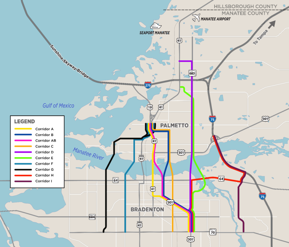
Corridors under study
Here are the 10 alternative corridors under study, according to the Florida Department of Transportation:
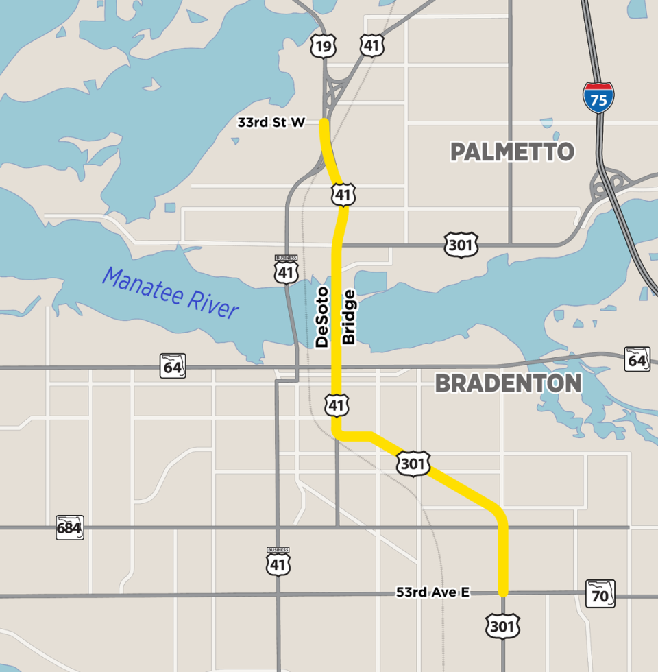
▪ Corridor A: Begins at the State Road 70 East/US 301 intersection, travels along US 41, and ends between 33rd Street West and the US 19/US 41 split. Corridor A utilizes existing roadways and crosses the existing DeSoto Bridge.
Travels through the cities of Bradenton and Palmetto plus Samoset, West Samoset, and Memphis.
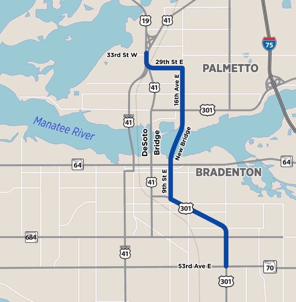
▪ Corridor B: Begins at the State Road 70 East/US 301 intersection, follows US 301 and Ninth Street East, includes a new bridge crossing over the Manatee River from Ninth Street East to 16th Avenue East in Palmetto, continues along 16th Avenue East, follows 29th Street East, and ends at the US 19/US 41 split. Corridor B utilizes existing roadways with the exception of the river crossing that will connect from Ninth Street East to 16th Avenue East on new alignment.
Travels through the cities of Bradenton and Palmetto plus unincorporated Samoset, West Samoset, and Memphis.
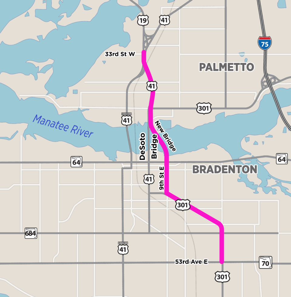
▪ Corridor AB: Begins at the State Road 70 East/US 301 intersection, follows US 301 and Ninth Street East, includes a new bridge crossing over the Manatee River from Ninth Street East to US 41, connects with and follows US 41 north of the river, and ends at the US 19/US 41 split. Corridor AB utilizes existing roadways with the exception of the river crossing that will connect from Ninth Street East to US 41 on new alignment. It is the shortest of the 10 study corridors.
Travels through the cities of Bradenton and Palmetto plus unincorporated Samoset, West Samoset, and Memphis.
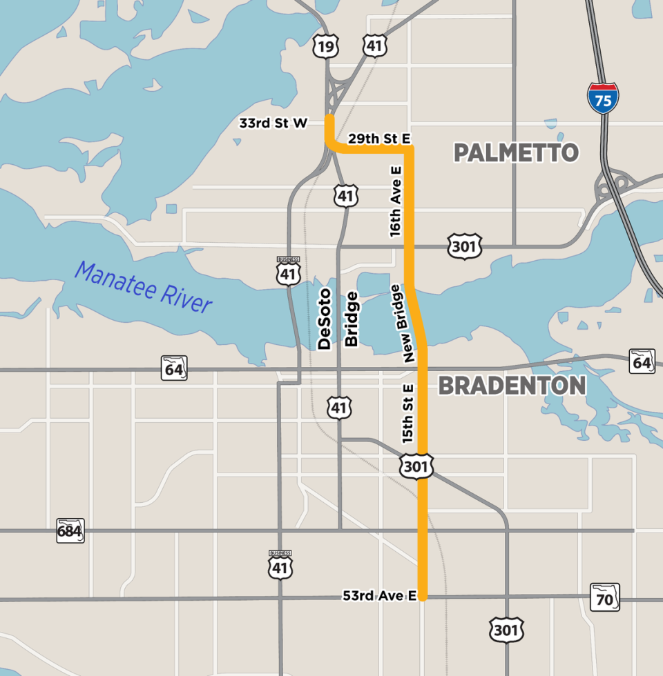
▪ Corridor C: Starts at the State Road 70 East/15th Street East intersection, follows 15th Street East, includes a new bridge crossing over the Manatee River from 15th Street East to 16th Avenue East, follows 16th Avenue East, travels along 29th Street East, and ends at the US 19/US 41 split. Corridor C utilizes existing roadways with the exception of the river crossing that will connect from 15th Street East to 16th Avenue East on a new alignment.
Travels through the cities of Bradenton and Palmetto plus unincorporated Samoset, West Samoset and Memphis.
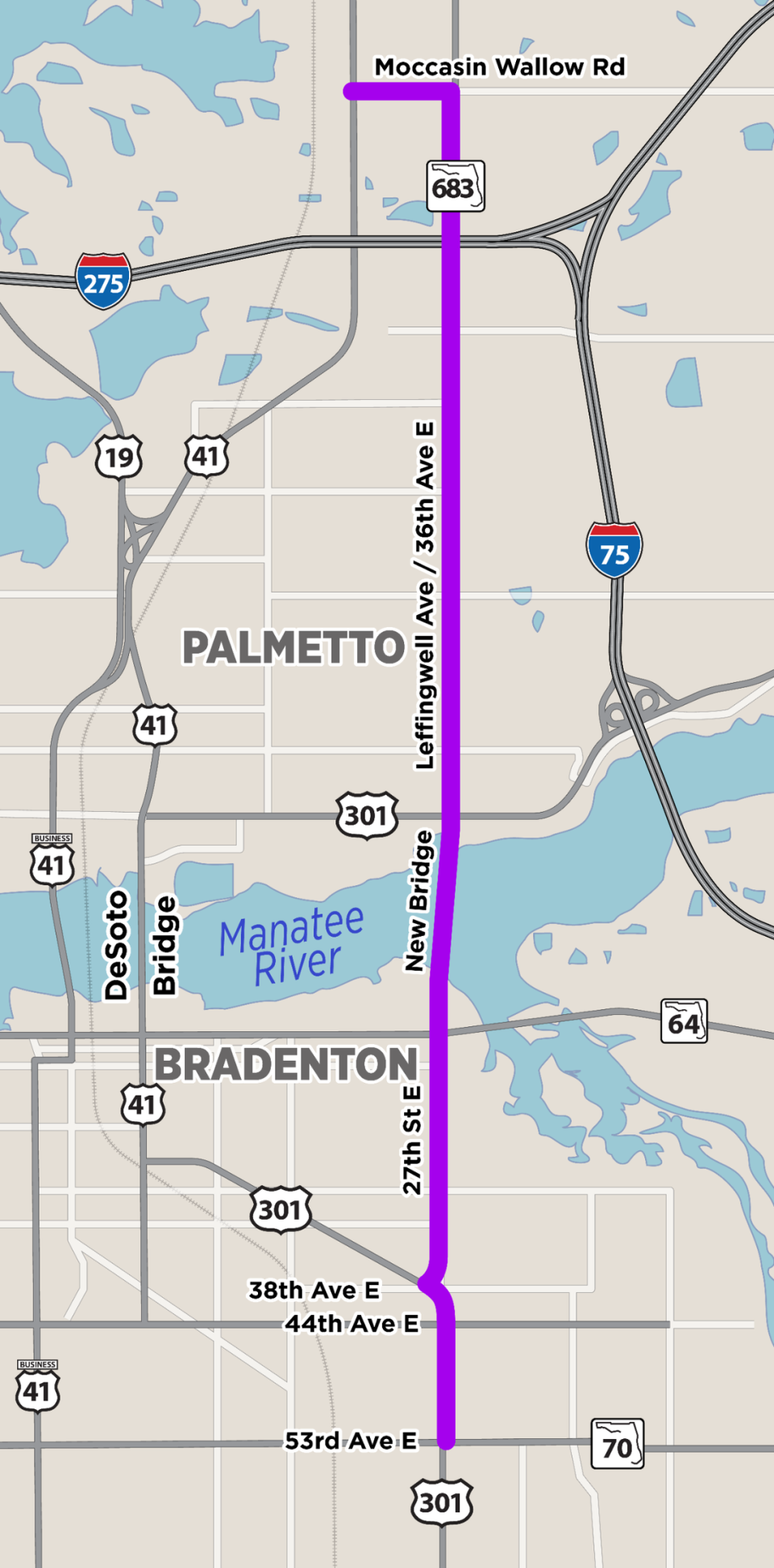
▪ Corridor D: Starts at the State Road 70 East/US 301 intersection, follows US 301, connects to 27th Street East via 38th Avenue East, includes a new bridge crossing over the Manatee River from 27th Street East to Leffingwell Avenue. Continues along Leffingwell Avenue/36th Avenue East, follows Moccasin Wallow Road, and ends at US 41. Corridor D utilizes existing roadways with the exception of the river crossing that will connect from 27th Street East to Leffingwell Avenue on new alignment.
Travels through the Bradenton, Samoset and Ellenton.
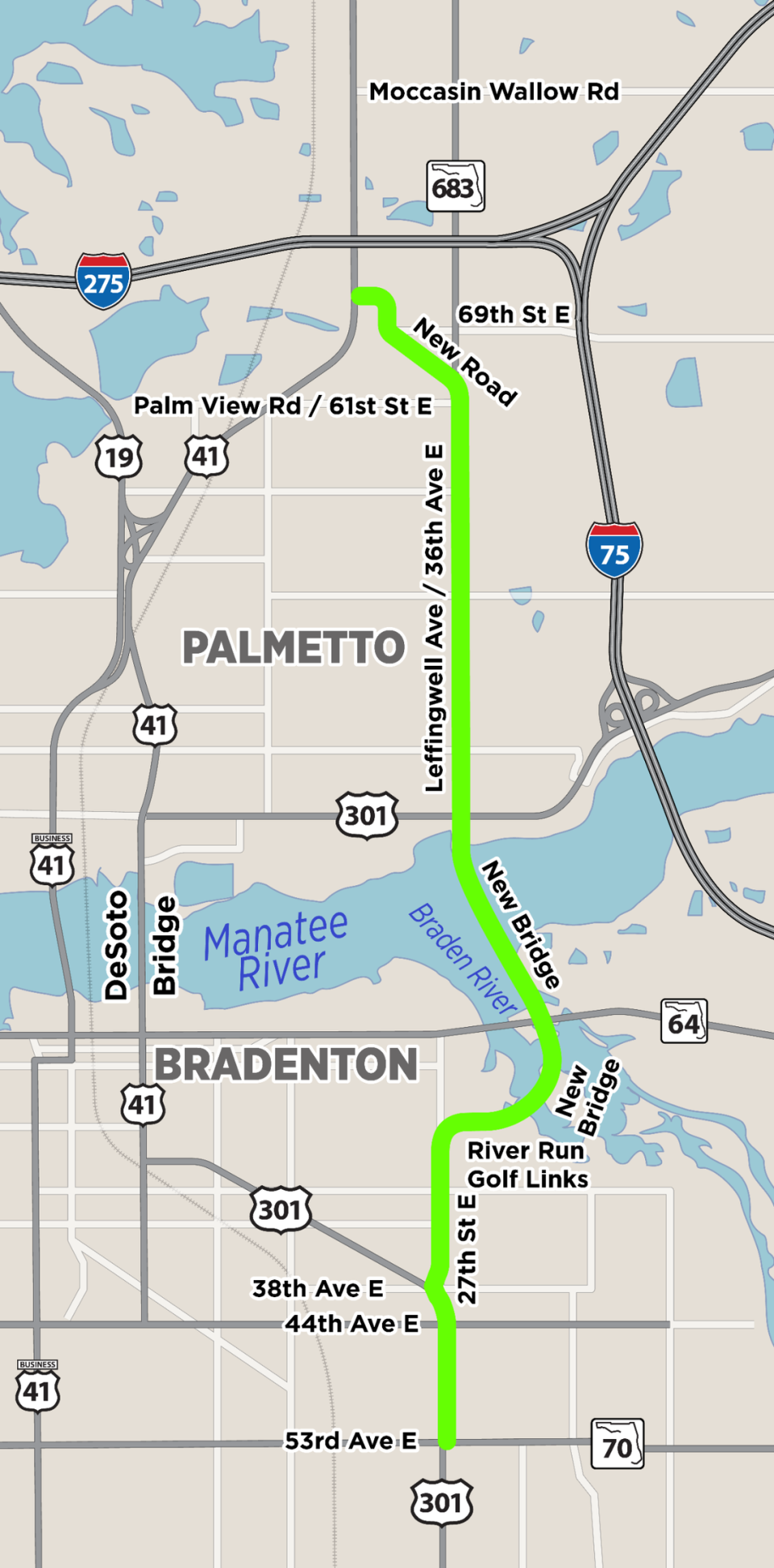
▪ Corridor E: Begins at the State Road 70 East/US 301 intersection intersection, follows US 301, connects to 27th Street East via 38th Avenue East, and includes a new bridge over the Manatee River from 27th Street East to Leffingwell Avenue.
As part of the new crossing, the corridor passes through River Run Golf Links-Bradenton Recreational Park and proposes an additional new bridge over the Braden River and SR 64. North of the Manatee River, it continues along LeffingwellAvenue/36th Avenue East to Palm View Road/61st Street East. It then creates a new roadway from Palm View Road/61st Street East to 69th Street East, follows 69th Street East and ends at US 41.
Corridor E combines existing roadways with new alignments. The new alignments are proposed in two locations: 1. The crossing of the Manatee River from 27th Street East to Leffingwell Avenue, which passes through River Run Golf Links-Bradenton Recreational Park and also crosses the Braden River and SR 64, and 2. the new connection between Palm View Road/61st Street East and 69th Street East.
Travels through the City of Bradenton plus Samoset and Ellenton.
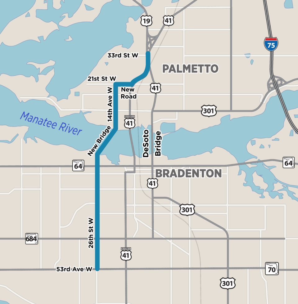
▪ Corridor F: Starts at the 53rd Avenue West/26th Street West intersection, follows 26th Street West.
Includes a new bridge crossing over the Manatee River from 26th Street West to 14th Avenue West.
Continues along 14th Avenue West north of the river, follows 21st Street West, creates a new roadway from 21st Street West to US 41, follows US 41 to the north, and ends at the US 19/US 41 split.
Corridor F combines existing roadways with new alignments. New alignments are proposed in two locations: 1. The river crossing that will connect from 26th Street West to 14th Avenue West. 2. The new connection from 21st Street West to US 41. Travels through Bradenton and Palmetto plus unincorporated west Bradenton.
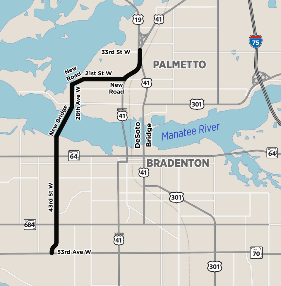
▪ Corridor G: Starts at the 53rd Avenue West/43rd Street West intersection, follows 43rd Street West.
Includes a new bridge crossing over the Manatee River from 43rd Street West to 28th Avenue West. Continues along 28th Avenue West north of the river, creates a new connection from 28th Avenue West to 21st Street West, follows 21st Street West. Creates a second new connection from 21st Street West to US 41. Follows US 41 to the north and ends at the US 19/US41 split.
Corridor G combines existing roadways with new alignments. New alignments are proposed in three locations: 1. The river crossing that will connect from 43rd Street West to 28th Avenue West, 2. The new roadway from 28th Avenue West to 21st Street West, and 3. The new connection from 21st Street West to US 41.
Travels through the cities of Bradenton and Palmetto plus unincorporated west Bradenton.
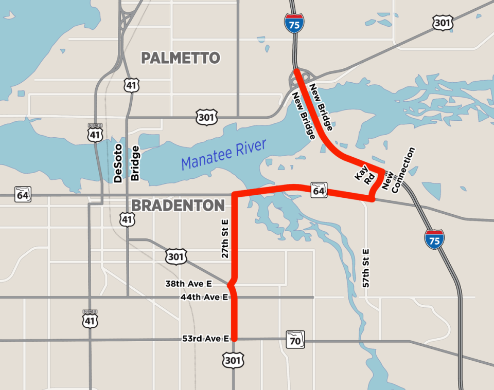
▪ Corridor H: Begins at the State Road 70 East/US 301 intersection, follows US 301, and connects to 27th Street East via 38th Avenue East. It continues along 27th Street East, SR 64, Cypress Creek Boulevard, and Kay Road. The corridor proposes a new roadway from Kay Road to I-75 to the west and north as it runs parallel to I-75 through a collector-distributor system and includes new bridge crossings over the Manatee River parallel to the I-75 bridges.
Corridor H ends at the I-75/US 301 interchange. Corridor H is the longest of the 10 study corridors. It combines existing roadways with new alignments, including the proposed new connection from Kay Road to I-75 and a parallel collector-distributor system alongside I-75. The corridor also includes new bridge structures parallel to the existing I-75 bridges across the Manatee River.
Travels through the Bradenton and east of the City of Palmetto.
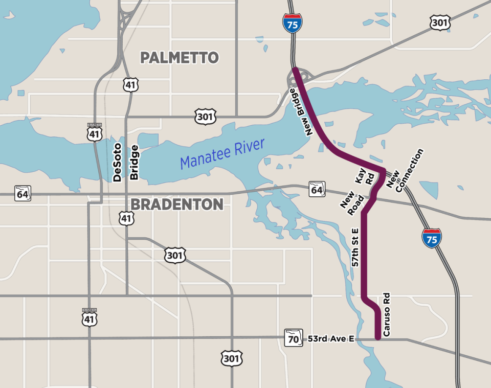
Corridor I: Starts at the State Road 70 East/Caruso Road intersection, follows Caruso Road, and includes a new connection from Caruso Road to 57th Street East. It runs along 57th Street East, proposes a new roadway from 57th Street East to Cypress Creek Boulevard, and continues along Cypress Creek Boulevard.
The corridor then follows Kay Road and proposes a new connection from Kay Road to I-75 to the west and north as it runs parallel to I-75 through a collector-distributor system and includes new bridge crossings over the Manatee River parallel to the I-75 bridges.
Corridor I ends at the I-75/US 301 interchange. Corridor I combines existing roadways with new alignments. The proposed new alignments include the connection from 57th Street East to Cypress Creek Boulevard and the connection from Kay Road to I-75. Additionally, a collector distributor system is planned to run parallel to I-75, along with new bridge structures parallel to the existing I-75 bridges over the Manatee River.
Travels through the Bradenton and east of the City of Palmetto.

