DeSantis orders storm prep as Florida watches tropical system brewing in Caribbean
- Oops!Something went wrong.Please try again later.
Meteorologists are closely watching a disturbance near Honduras that, early models show, could affect Florida next week. It’s too soon to know where exactly the system may strike or how strong it will be, but state officials have already started preparing.
Florida Gov. Ron DeSantis has directed the Florida Division of Emergency Management to prepare for the “potential tropical system.”
“Residents should remain vigilant and prepare for possible impacts early next week,” he posted on X.
I’ve signed an executive order declaring a state of emergency for 33 counties in preparation for Invest 93L. Issuing this order today ensures communities have time to prepare for the storm system which could have impacts along the Gulf Coast next week.
Floridians should have a…— Ron DeSantis (@GovRonDeSantis) August 26, 2023
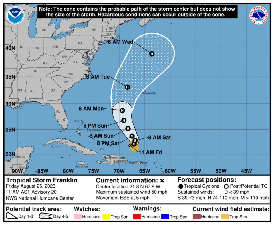
Also brewing in the Atlantic are Tropical Storm Franklin, which could be a hurricane this weekend, and three other tropical disturbances, including a new one in the far east Atlantic. Florida doesn’t have to worry about these systems for now, but Bermuda may feel the edges of Franklin.
Here are the forecasts from the National Hurricane Center’s 2 p.m. Friday update:
Florida officials watching new tropical system
The system to watch is an area of low pressure off the northeastern coast of Honduras. The hurricane center said it could become a tropical depression late this weekend or early next week as it drifts north over the Caribbean Sea and into the Eastern Gulf of Mexico.
As of Friday afternoon, chances of it becoming a depression were at 40% in the next two days, 80% in the next seven — a slightly higher figure than earlier in the day.

Early storm models were inconsistent at first but for the last few runs have shown a tropical storm headed toward Florida’s west coast by Tuesday or Wednesday.
What the system will find by the time it gets to the Gulf is still up in the air. Waters are warmer than normal, which could fuel a potential storm, but there’s also quite a bit of unfriendly wind shear in the Gulf for the next few days.
“It’s a fine line whether the upper winds over the Gulf will enhance the system or deter it from strengthening,” Bryan Norcross, a hurricane specialist at Fox Weather, posted on the social media site X, formerly known as Twitter.
The strength of a potential system weighs heavily into the path it could eventually take. Andy Hazelton, an associate scientist at the University of Miami and NOAA’s Hurricane Research Division, said that a weaker system could move faster and strike lower in the state, while a slightly stronger system could be drawn more to the Panhandle region.
ECMWF ensemble continues to hint at a couple possible scenarios for a Gulf system: 1) Weak system moves quickly across S FL. 2) A slightly stronger system (due to more erosion of the trough and more time over the warm Gulf) moves up towards the FL Big Bend area. (1/2) pic.twitter.com/oHNbB27GGU
— Andy Hazelton (@AndyHazelton) August 25, 2023
The next storm name is Idalia.
Tropical Storm Franklin on track to become hurricane
Tropical Storm Franklin was foundering a bit in some high wind shear, a storm shredder, on Friday, and lost a little strength Friday morning.
But forecasters said the storm was still in good shape to strengthen into a Category 2 hurricane with 110 mph winds over the weekend as it moved northeast, possibly skirting Bermuda.
As of the 11 a.m. Friday advisory, Franklin was moving east-southeast at 5 mph with maximum sustained winds of 50 mph.
Three other disturbances still brewing in Atlantic
The hurricane center was still tracking the remains of former Tropical Storm Emily, which was just a trough of low pressure about 950 miles east of Bermuda.
It could regenerate into a tropical depression or storm during the next day or so, but forecasters keep lowering those chances. It had a 10% chance of forming in the next two or seven days, a drop from Friday morning.
The second disturbance, another area of low pressure midway between the Cabo Verde Islands and the northern Lesser Antilles, could become a tropical depression by early next week. It had a 20% chance of forming in the next two days and a 50% chance in the next seven.
The hurricane center started tracking a third disturbance Friday afternoon, a tropical wave expected to move off Africa’s west coast next week. They gave it no chance of forming in the next two days and a 20% chance of strengthening into a tropical depression in the next seven days.

