Can you fly a drone in the Poconos? Yes, but some spots are off-limits
Did you get a drone for Christmas? Are you taking up a new hobby in 2023?
Here’s what you should know about flying a drone in the Poconos.
Register your drone
"All drones, both recreational- and commercial-use weighing between 0.55 lbs and 55 lbs, must be registered with the Federal Aviation Administration,” the Pennsylvania Department of Transportation says.
Go to faa.gov/uas/getting_started/register_drone for details. The fee is $5 and registration is good for three years.
Additionally, recreational pilots must take The Recreational UAS Safety Test (TRUST) and carry proof that they passed.
Fly safely
Rules for recreational and commercial users vary in some respects, but all pilots should keep their drones within eyesight and no higher than 400 feet. Don’t interfered with manned aircraft or with emergency response activities.
Check with PennDOT (bit.ly/3YeLqHb) and the FAA (faa.gov/uas/recreational_flyers) for more.
Check before you fly
The FAA recommends you use B4UFLY, an app made with the help of Aloft, a drone technology company. The free service is also available in a desktop version at b4ufly.aloft.ai.
Here are some highlights of where you can — and can’t — fly drones in the Poconos.
The Delaware River
Taking a zoomed out view of northeastern Pennsylvania, you’ll notice that B4UFLY shows two major red zones along the borders with New York and New Jersey. These are the Upper Delaware Scenic and Recreational River and Delaware Water Gap National Recreation Area.
Drone flights are prohibited at both National Park Service sites unless approved by the superintendent in writing.
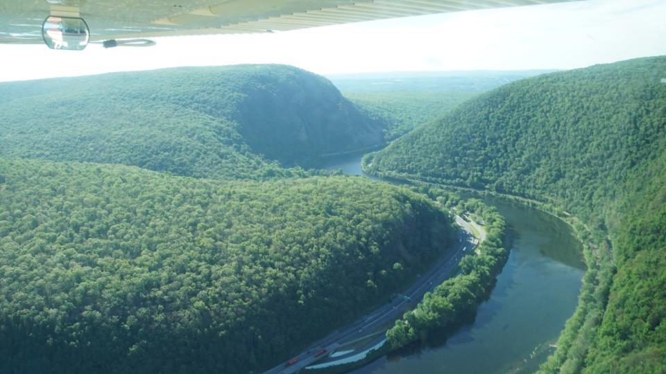
“The Superintendent and other NPS authorities have decided on an interim basis that to maintain public health and safety, protection of environmental or scenic values, protection of natural or cultural resources, implementation of management responsibilities, equitable allocation and use of facilities, and to avoid conflict among visitor use activities the use of unmanned aircraft will not be allowed within Delaware Water Gap National Recreation Area. The park has several active nesting sites of threatened wildlife and the use of these unmanned aircraft would affect wildlife, view sheds and create unreasonable and unauthorized noise levels within these areas,” the recreation area says in its rules and regulations.
The Upper Delaware policy includes similar language, and mentions nesting bald eagles as being “of special concern.”
There is a small gap between these two red zones; you might consider going to Matamoras to get drone views of the river.
State parks
For the most part, you can’t fly drones at state parks in Pennsylvania. However, six parks do have designated flying sites, including Beltzville, Lackawanna and Prompton.
“Drone and (unmanned aerial systems) operators need to contact the park office of the flying site that they plan to visit to ensure compliance with all rules and regulations,” the Pennsylvania Department of Conservation and Natural Resources says. “Please be advised that the entire park at each of these locations is not open to UAS or drone usage. Only the designated flying site within each park is open to UAS use.”
Tobyhanna Army Depot
Drones are prohibited over this military installation.
“If you see something, say something - unauthorized unmanned aircraft systems have the ability to surveil, disrupt or potentially strike Army assets. It is everyone’s responsibility to report all sightings of unmanned aircraft systems,” the depot says on its Access Control page.
United States Penitentiary, Canaan
Drones flights are prohibited over prisons such as USP Canaan, which is near Waymart in Wayne County.
Lake Wallenpaupack
This 5,700-acre lake is clear for takeoff, according to B4UFLY.
This article originally appeared on Pocono Record: Can you fly a drone in the Poconos? Here's where you can, and can't

