A foot of snow, blizzard conditions to threaten central US


A major storm developing across the central U.S. in the coming week is forecast to bring a historic snowfall and blizzard conditions to portions of the northern tier.
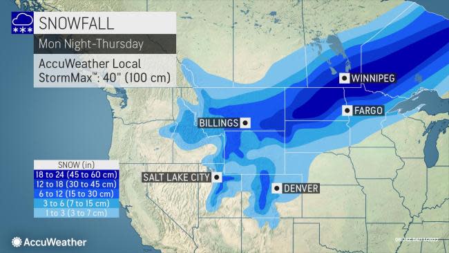
A southward dip in the jet stream across the West is likely to bring cold, Canadian air into portions of the West Coast before it expands across the Rockies and the northern Plains into the early part of the week. This cold will set the stage for a more robust amount of snow as the week progresses.
The more impactful storm is expected to pivot through the interior West on Monday, strengthening as it does so. This will allow for locally heavy snow across portions of the Wasatch Range in Utah and the Bitterroot and Rocky Mountains of Idaho and Montana, while rain falls and soaks some of the valley floors.
 |
As the storm emerges from the Rockies and swings northeastward across the Plains later Tuesday, snow will encompass Wyoming and the Colorado Rockies before spreading into western Nebraska, North and South Dakota and Minnesota through Tuesday night.
An expansive swath of a few inches of snow is anticipated from Idaho and Utah out into the Arrowhead of Minnesota by the time the storm is said and done, with up to two feet of snow likely across North Dakota, far northern Minnesota and into southern Manitoba and Ontario.
 |
The exact track of the storm will determine where the heaviest snow extends from the Rockies to the northern Plains. However, communities from Bismark, North Dakota to Winnipeg, Manitoba and well into Ontario, could see over 18 inches of snow.
"A swath of heavy snow is expected to linger and be slow moving, allowing for perhaps 2-3 feet of snow to pile up in some locations before the snow ends," said AccuWeather Senior Meteorologist Alex Sosnowski. AccuWeather meteorologists are forecasting an AccuWeather Local StormMax™ of 40 inches (100 cm).
In Grand Forks, North Dakota, the snowiest April ever on record was in 1970 when 17 inches of snow fell. It is not out of the realm of possibility that this snow storm alone could produce that much snow, let alone when adding in the half an inch of snow the city has already seen this month.
At this time, meteorologists say it appears that Denver may be just outside of where the storm drops heavy snow. However, a southeastward shift in the storm's track could put the Mile High City in the throes of some major snow.
The inches of snow expected some of the region is also expected to help with the drought, according to AccuWeather Senior Meteorologist Matt Benz. Such locations include portions of eastern Montana, Wyoming and the western Dakotas will
CLICK HERE FOR THE FREE ACCUWEATHER APP
The slowness of the storm as the storm treks eastward Wednesday will allow for it to strengthen. As it does so, gusty winds are also expected to develop in areas where the snow will be falling.
"Blizzard conditions are likely to unfold as the storm gains strength, snow piles up and winds increase," said AccuWeather Meteorologist Brandon Buckingham. Extensive blowing and drifting snow can occur which could result in road closures close due to high-velocity winds and massive drifts.
 |
It is possible the storm far exceeds the blizzard criteria of one-quarter mile visibility or less with winds of 35 mph or greater for three consecutive hours. Should the storm develop to its full potential, gusts may frequent 50 mph with near-zero visibility for hours in some cases over parts of the northern Rockies and Plains.
Benz also noted that the gusty winds could create drifts up to 20 feet.
Reduced visibility concerns, as well as snow piling on the roadways making for slick conditions, are expected from the Rockies to the Upper Midwest as this storm plows through into midweek. Motorists driving along portions of interstates 25, 80, 90, and 94 should plan on delays and difficult travel conditions as the storm passes.
"Most long-term residents of the northern Plains and Rockies know that April can deliver tremendous snowstorms," Buckingham added. Portions of the Black Hills in South Dakota, average 10-20 inches of snow during the month of April. It is possible that this region, and others, could pick up an entire month's worth of snow from this one storm.
The highest three-day snowfall total ever recorded in South Dakota during the month of April was in Custer, where snow ending on April 20, 1920 totaled 44 inches.
For the latest weather news check back on AccuWeather.com. Watch the AccuWeather Network on DIRECTV, Frontier, Spectrum, fuboTV, Philo, and Verizon Fios. AccuWeather Now is now available on your preferred streaming platform.
