Forecast shows wintry weather in the Topeka area on Friday night. Here’s what to expect.
Old Man Winter's coming back to Topeka.
The area has recently seen uncharacteristically mild weather for this time of year, with temperatures soaring to as high as 64 degrees Tuesday, according to the National Weather Service.
But with temperatures falling and chances for precipitation rising, forecasters predict varying amounts of snow will fall Friday night and Saturday in north-central, northeast and east-central Kansas.
How much snow will fall?
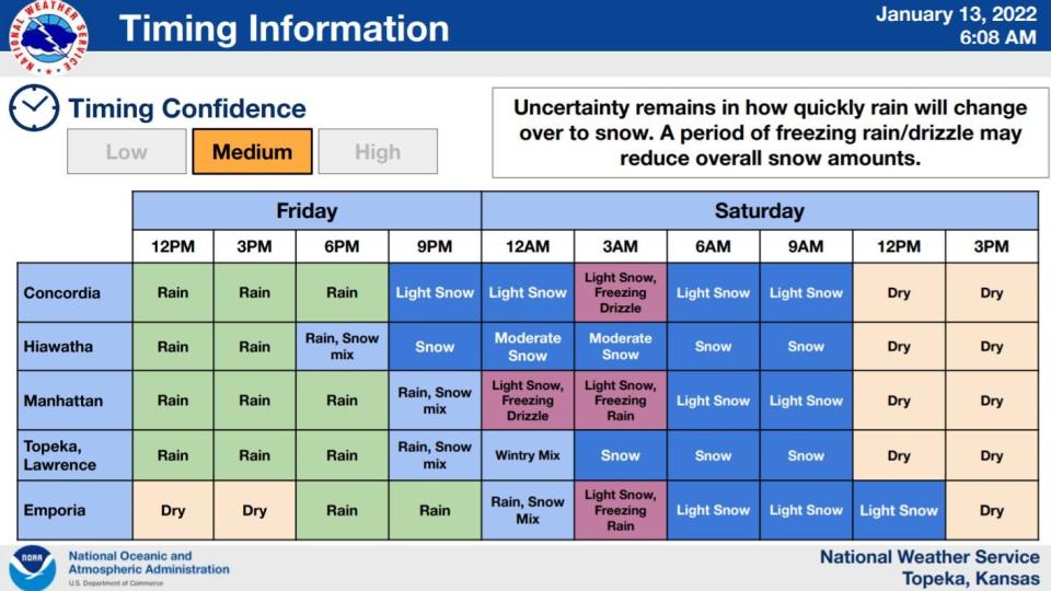
The snow should be preceded by rain throughout much of the day Friday in almost all the area involved, forecasters say. It is expected to begin falling Friday night.
A graphic posted on the website of the weather service's Topeka office indicated snowfall totals are anticipated to be from:
• 1 to 3 inches at Topeka, Manhattan, Marysville and Ottawa.
• 1 to 4 inches at Holton.
• 2 to 4 inches at Kansas City, Mo.
• And 2 to 5 inches at Hiawatha and St. Joseph, Mo.
Lower snowfall amounts are expected to the west, with between a trace and 1 inch falling at Salina and Newton and between a trace and 2 inches at Concordia and Emporia.
Will there be freezing rain?
Freezing rain and drizzle will be possible Friday night and Saturday morning in an area running southeast from roughly Manhattan to roughly Emporia, according to the weather service. Topeka is not part of the area involved.
Snow is expected to end late Saturday morning everywhere except Emporia, where the snow is anticipated to end early Saturday afternoon.
What are the chances for heavy snow?
A graphic posted on the weather service website indicated the chance for 2 inches or more of snow to fall will be 6% at Newton, 11% at Salina, 19% at Concordia, 39% at Manhattan and Ottawa, 44% at Topeka, 63% at Holton, 69% at Kansas City, Mo., 78% at Hiawatha and 80% at St. Joseph, Mo.
A separate graphic said the chances for 4 inches or more to fall will be 1% at Concordia, 2% at Ottawa, 5% at Topeka, 7% at Manhattan, 8% at Concordia, 16% at Kansas City, Mo., 20% at Holton, 38% at St. Joseph, Mo., and 43% at Hiawatha.
How cold will Topeka get?
Topeka temperatures are anticipated to dip as low as 24 degrees Friday night, then rise to as high as 30 on Saturday, according to the weather service.
Winds could gust as high as 25 mph on Friday night and 30 mph on Saturday, it said.
How will the weather be on Monday's holiday?
After Saturday, conditions will become progressively milder, forecasters say.
They predict Sunday will bring a high temperature around 36 degrees, with mostly sunny skies.
A high near 44, accompanied by mostly sunny skies, is anticipated for Monday's holiday, Martin Luther King Day.
Temperatures are then expected to continue upward, reaching 51 degrees under sunny skies on Tues
This article originally appeared on Topeka Capital-Journal: Topeka winter storm brings snow to forecast Friday, Saturday, NWS says

