Forecast: 'Spotty' snow showers to fall in Louisville during morning commute
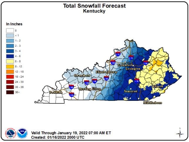
Much of the eastern half of Kentucky was hit by a winter storm Sunday forecast to dump 4 to 8 inches of heavy snow across the region.
Louisville appeared largely spared from the Sunday system that was set to stay east of a line stretching from Hopkinsville to Louisville. However, some parts of the city got a light dusting of wet snow and small ice pellets late Sunday afternoon into the evening, according to the National Weather Service.
A few minor accidents were reported on various roadways in Jefferson County, but there didn't appear to be any injuries as of Sunday at 9 p.m.
Related: Sunday storm misses Louisville, but snow still in forecast
Cities like Frankfort, Campbellsville and Bowling Green were under a winter weather advisory, while counties and cities east — including Lexington, Somerset and Corbin — were under a winter storm warning until 3 a.m. Sunday, with more snow expected to impact the morning commute.
"It’s going to be a pretty sharp cutoff," National Weather Service meteorologist Brian Schoettmer said Sunday.
Heavy, wet snow
A second system could bring approximately half an inch to the Jefferson County area Monday morning, Schoettmer said.
"Spotty" snow showers are expected to fall around dawn, during the morning commute on Martin Luther King Jr. Day.
"We want people to definitely pay attention on the morning commute," Schoettmer said.
Snowfall is again possible Wednesday evening in the Louisville area, as daytime rainfall hits cold evening air, Schoettmer said, though it is not expected to be a major snow event.
Meteorologists and government officials warned the heavy, wet snow Sunday could make for more difficult shoveling and cause stress on roofs, power lines and other surfaces.
Kentucky Transportation Cabinet crews and its contractors reported to county maintenance facilities early Sunday to load salt and equipment and start patrolling, according to a news release.
Tornado: Mayfield candle factory to lay off 250 employees
Traffic trouble
At about 5:45 p.m. Sunday, Kentucky State Police announced I-75 southbound in Laurel County was closed around mile marker 47 while authorities salted and removed snow. Tractor-trailers and other vehicles were having trouble making it up a hill, and traffic was backed up for at least two miles.
🚨ALERT: I-75 SB Laurel Co🚨
"Due to tractor trailers/vehicles not able to get up the hill at MM 47, the interstate is closed while @kytc crews scrape/salt the road. Expect Delays!" -Tpr. Scottie Pennington, Post 11 London
#Izzy #kywx pic.twitter.com/BpdQeZPFzi— KY State Police (@kystatepolice) January 16, 2022
As of 8 p.m., Kentucky Emergency Management reported heavy snow and hazardous driving conditions in eastern parts of the state, especially the corridors of southern Interstate 75 and Interstate 64 as snow would quickly re-cover roadways after they'd been plowed.
Stop-and-go traffic between Mount Vernon and London continued throughout the evening because of the combination of heavy snow and steep terrain.
More than 8,700 Kentuckians in eastern and south-central parts of the state were without power as of 9 p.m. Sunday, according to a state power outage tracker.
Affected areas were forecast to receive an average of 4 to 6 inches of snow, though some spots could see up to 8 inches, Schoettmer said.
The heaviest accumulations were forecast along and east of a line between the Lake Cumberland region through the I-75 corridor.
As of Sunday evening, nearly all flights out of Muhammad Ali International Airport remained on time, though the airport issued an advisory Sunday for travelers to check the status of their flight before heading to the airport, given the winter storm's reach across multiple southeastern states.
Tips to stay safe:
Travel only as necessary during major winter weather events, and make sure to have ice scrapers, jumper cables, flashlights, blankets, a cell phone charger, non-perishable snacks and a first aid kit in the event of getting stranded.
Winterize your vehicle. Make sure the car battery, tire pressure, brakes, defroster, headlights and windshield wipers are in working order before you travel.
Drive slowly in wintery conditions, regardless of the type of vehicle you're in. It takes more time and distance to stop in poor weather conditions.
Pay attention to weather advisories and allow more travel time.
Slow down when approaching intersections, off-ramps, bridges or shaded areas, as these are the first to become icy. Black ice, or a thin coating of clear ice that can form on pavement, is difficult to see.
Maintain a safe distance from snowplows and other heavy highway equipment. Do not pass snowplows on the shoulder.
Eliminate distractions while driving in bad weather.
Abide by Kentucky's quick clearance law: Move vehicles to the shoulder in the event of a non-injury crash.
Reporter Matthew Glowicki can be reached at mglowicki@courier-journal.com, 502-582-4000 or on Twitter at @MattGlo.
This article originally appeared on Louisville Courier Journal: Winter storm misses Louisville, KY: What to know about Monday forecast

