Far-reaching storms to stymie travelers in over a dozen states


The Thanksgiving leftovers have been exhausted and holiday gifts have been purchased, and now it's time to go back home. AccuWeather meteorologists warn that the trip might be bumpy in parts of the Midwest and East this weekend while travelers across the West should enjoy smooth sailing.
The dual weather pattern, highlighted by a sprawling area of high pressure across the West and multiple storms in the Midwest and East, will be responsible for the vastly different travel forecasts for each half of the nation.
According to AAA, 55.4 million people were expected to travel by air, road and rail in the United States for the Thanksgiving holiday. The association also says that Sunday is typically the busiest day to travel back home, but Monday is also a popular day to fly.
Even in the nicest weather, traveling back home on the Sunday after Thanksgiving is not for the faint of heart. AAA says that cities such as Houston, New York, San Diego and San Francisco experience their busiest period of the entire extended holiday weekend on Sunday, with highways most packed for drivers between 3 p.m. and 5 p.m., local time.
 |
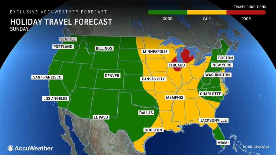
Unfortunately for those getting away in a wide area of the Midwest, as well as a portion of the East, Sunday will feature the most disruptive weather conditions, complete with snow, rain and gusty winds.
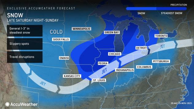
"The same storm that brought the accumulating snow to the Rockies and Plains on Friday and Saturday is expected to join forces with another moving south from Canada," said AccuWeather Meteorologist Brandon Buckingham. "This will bring accumulating snow and slippery travel to the Midwest and Great Lakes on Sunday."
 |
The Twin Cities of Minneapolis and St. Paul, Chicago, Milwaukee and Detroit are among the metropolitan areas where there can be slippery travel, especially on secondary roads and elevated surfaces, to end the weekend on Sunday. While a significant amount of snow is not anticipated, enough will fall to reduce visibility, which can cause travel delays at numerous airports, including at O'Hare International in Chicago, the nation's fourth busiest air hub.
The storm and the colder air rushing in behind it will also kick off a round of lake-effect snow downwind of the Great Lakes into Sunday night and beyond. The bands of heavy snow may seriously imperil travelers with near-whiteout conditions in the normally-favored areas across western Michigan, northeastern Ohio, northwestern Pennsylvania and western New York.
Because of the prospects of slippery travel from the wintry weather, Midwest travelers with the flexibility to head out earlier in the weekend should consider doing so.
While the snow and bitterly cold winds will steer clear of the Northeast and South, areas of rain can slow travel for millions more. Wet weather is expected to move through portions of the Ohio and Tennessee valleys from the same storm moving through the Midwest, as well as with another storm forming along the mid-Atlantic coast. Baltimore, Cincinnati, Philadelphia and Pittsburgh are among the cities where travel, especially later in the day and into Sunday night, can be slowed by brief downpours and road spray.
 |
Heavier downpours are expected to unfold across a corridor in the Southeast due to a stalled front and an influx of moisture from the Gulf of Mexico. This can occur into Sunday night across parts of western Florida and the Florida Panhandle, as well as southern Georgia, including in Jacksonville and Tallahassee.
The West will be graced with dry weather for travelers again on Sunday, with much of the Plains now also experiencing quiet weather conditions, save for some strong wind gusts impacting higher-profile vehicles in the northern Plains. New England should also enjoy calm conditions during the day, but rain and an interior wintry mix can arrive at night.
"With colder air in place across the interior Northeast, some snow will blanket the higher terrain beginning Sunday night," said AccuWeather Senior Meteorologist Joe Lundberg. "This includes portions of the Adirondacks, the Green and White Mountains, as well as western Maine."
While much of the U.S. will revel in quiet weather as many return to work and school, some travelers in the East will still be contending with gusty winds and some localized snow as Monday arrives. The day is known for being busier for last-minute travel at airports, and AccuWeather believes some flights can be delayed or grounded that day due snow and gusty winds in the Northeast.
 |
The season's first significant and widespread lake-effect snow event is expected to last into and perhaps even peak on Monday downwind of the Great Lakes. Heavy snow will also unfold across parts of northern New England as the same storm that will bring rain to the big cities in the Northeast on Sunday night pulls into Atlantic Canada.
"As the storm deepens and moves away Monday and Monday night, the coldest air so far this season will be drawn across the Great Lakes," said Lundberg. "In turn, bands of lake-effect snow will form and disrupt travel into Tuesday."
Localized amounts of more than a foot of snow are expected, and in combination with wind gusts over 30 mph, there can be whiteout conditions along and just southeast of the Interstate 90 corridor from Cleveland to Erie and Buffalo, as well as in the Tug Hill Plateau region in New York to east of Lake Ontario.
 |
The initial blast of subfreezing air arriving with and behind the precipitation can lead to some icy spots for those commuting on Monday morning in the upper Ohio Valley and interior Northeast, especially from Ohio and West Virginia north through the western half of Pennsylvania and parts of upstate New York.
Outside of the ripple effects on air travel caused by the snow and wind in the Great Lakes and Northeast, the rest of the country will enjoy remarkably quiet conditions on Monday, as high pressure will now extend into the South, putting an end to the wet weather there.
Want next-level safety, ad-free? Unlock advanced, hyperlocal severe weather alerts when you subscribe to Premium+ on the AccuWeather app. AccuWeather Alerts™ are prompted by our expert meteorologists who monitor and analyze dangerous weather risks 24/7 to keep you and your family safer.
