This year, forecasters get a hurricane model upgrade. Will better predictions follow?
Forecasting hurricanes is a tricky science.
Whether a storm forms, strengthens or turns in a specific direction can be decided by dozens of factors, from ocean temperatures to the direction of winds to the amount of dirt floating in the air.
But hurricane scientists are better than ever at predicting where these storms are going and what kinds of impacts they’ll bring. Forecasters can now offer a two-day forecast that is as accurate as a one-day forecast was a decade ago, and a five-day forecast that’s more accurate than a three-day forecast was two decades ago.
A big part of that is due to the technological upgrades from hurricane models — programs run on some of the fastest supercomputers in the world based on thousands and thousands of scraps of data.
And this season, that technology takes another leap forward with the introduction of a new, more accurate hurricane model that the National Oceanic and Atmospheric Administration spent the last three years developing.
READ MORE:
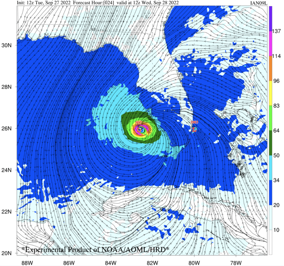
On June 27, forecasters at the National Hurricane Center will start to use the Hurricane Analysis and Forecast System, or HAFS, to scan the Atlantic for possible new storms and to track them if they develop.
Early results are promising. An experimental version of HAFS run for the last three storm seasons was 10 to 15% more accurate on average at predicting the path of a storm than the current best model, the Hurricane Weather Research and Forecast System or HWRF.
Dr. Michael Brennan, director of the National Hurricane Center, called the new model an exciting update for his team of forecasters.
“The more models you have, the better picture you can get with the uncertainty,” he said.
What are hurricane models?
HAFS is the newest model to join the fray, but it will be one of many forecasters use to track storms. Some of the best-known include the European Model (or Euro), the Global Forecast System (or GFS) and the U.K. Met Office Global Model.
These super computer-powered programs spit out projections of weather conditions in a certain region — or the entire globe — four times a day. These projections make up the infamous “spaghetti models” that are so prevalent when a storm is coming. Those colorful lines are the model’s best guesses at where storms might form and where they might go.
But they’re definitely not perfect. Every year, different models perform better than others, and no one storm model gets everything totally correct.
What those hurricane spaghetti models all over social media actually mean
That’s why the hurricane center uses them, along with their expert knowledge, to craft its own projection of where a potential hurricane might go.
“There’s still a lot we don’t know,” Brennan said. “We’re always trying to piece together our best analysis with an incomplete data set.”
To combat that, NOAA has been steadily rolling out new technology to better understand what goes on inside and around hurricanes, from satellites that can zoom in closer than ever to high-tech “dropsondes” that hurricane hunters drop from planes inside hurricanes that sample the storm as they fall, sending that data back to forecasters.

NOAA is also launching uncrewed drones that soar through the air, saildrones that scoot along the rough waves near a storm and devices that glide, drift and float under the sea’s surface.
All that data gets fed to NHC forecasters, and in the case of the new model, HAFS, directly into the computer program that spits out storm projections.
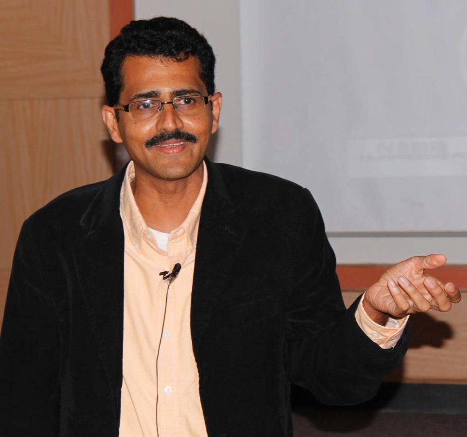
“At this stage, the observations are going to help us understand, how do I better attune the model so that it produces a more real reality?” said Sundararaman Gopalakrishnan, a senior meteorologist at NOAA and leader of the modeling team that developed HAFS.
A closer look at storms
This year, HAFS will run alongside the two NOAA models developed before it — HWARF and HMON. But starting next season, it will replace them.
All three have an innovation called a “moving nest.” It’s a lot of work for global models to display images of the entire world with a resolution high enough that scientists can see crucial details. But these models work a little differently. They show the entire world at a lower resolution, then allow researchers to zoom in on certain spots in much better detail, sort of like a mobile magnifying glass.
“It’s like a high-definition TV. The better the resolution is, what we found is, the better the intensity prediction is,” said Gopalakrishnan.
The nests, which stretch over about 800 kilometers, show a picture that allows researchers to zoom in to about a two-kilometer resolution. Outside the nests, that resolution is 6 kilometers.
That’s better than the HWARF, Gopalakrishnan said, which offers a resolution of about 13.5 kilometers for its base.
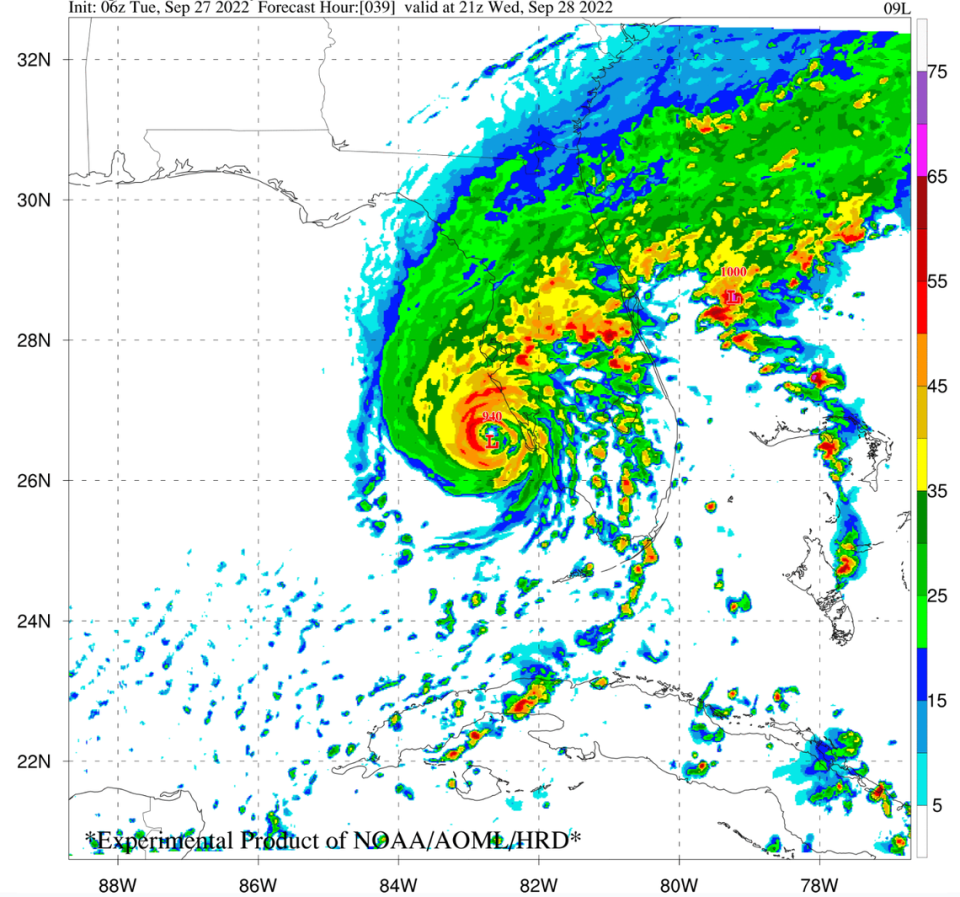
A close-up view is a big deal for spotting one of the hardest storm phenomena to predict — rapid intensification. That’s when a storm gets very strong, very quickly. Officially, a storm must increase its maximum sustained winds by at least 35 mph in a 24-hour period.
Floridians might remember when Hurricane Michael did just that. Although the hurricane center was able to correctly determine where and when Micheal would strike in 2018, the storm strengthened practically overnight from a Category 2 to a Category 5 storm, surprising some residents who prepared for a weaker storm.
And while forecasters have gotten better at predicting when a storm might intensify — capturing about 12% of rapidly intensifying storms in the 2010s and about 32% these days — it’s still not an exact science.
Gopalakrishnan said the main ingredients for rapid intensification are warm sea surface temperatures, which act like gasoline to the engine of a hurricane, and winds traveling in a favorable direction. When winds work with the direction a storm is swirling instead of against it, that’s known as low wind shear and can lead to stronger, more organized storms.
“It’s a battle between the shear and the sea surface temperatures,” he said. “But for rapid intensification, one more factor that becomes important is where you trigger the condition.”
“That’s where the resolution comes in.”
Gopalakrishnan said his team found that bursts of strong thunderstorm activity, paired with low shear and warm water, were more likely to set off a rapid intensification reaction. A closer look at the area near a storm, like HAFS offers, gives researchers a better chance to spot small triggers like that.
“We are getting better and better at understanding it,” he said. “The more observations we have to understand it, the better we will be at predicting it in the future.”
Hurricane category isn’t the full picture. Scientists suggest it’s time for a new scale
Although this is the first year HAFS will be officially in operation, Gopalakrishnan’s team is already at work on the next evolution of the model. The idea is to have multiple moving nests working at the same time, so forecasters can track multiple storms at once and even see what happens when they’re near each other. It could be operational as soon as 2025.
“We do know there are storm-storm interactions that aren’t captured as well as they could be now,” said Brennan, from the hurricane center. “It’s certainly a promising development.”
But, both meteorologists cautioned, all the best technology in the world is useless if people in the path of danger don’t respond to the warnings they’re getting. The track forecast will never be perfect, and the intensity of a storm could always change as it nears land.
“We don’t want people to get hung up on small changes to the track and intensity, category, whether it has a name or not now,” Brennan said. “It’s the hazards that kill people. It’s not these other things.”

