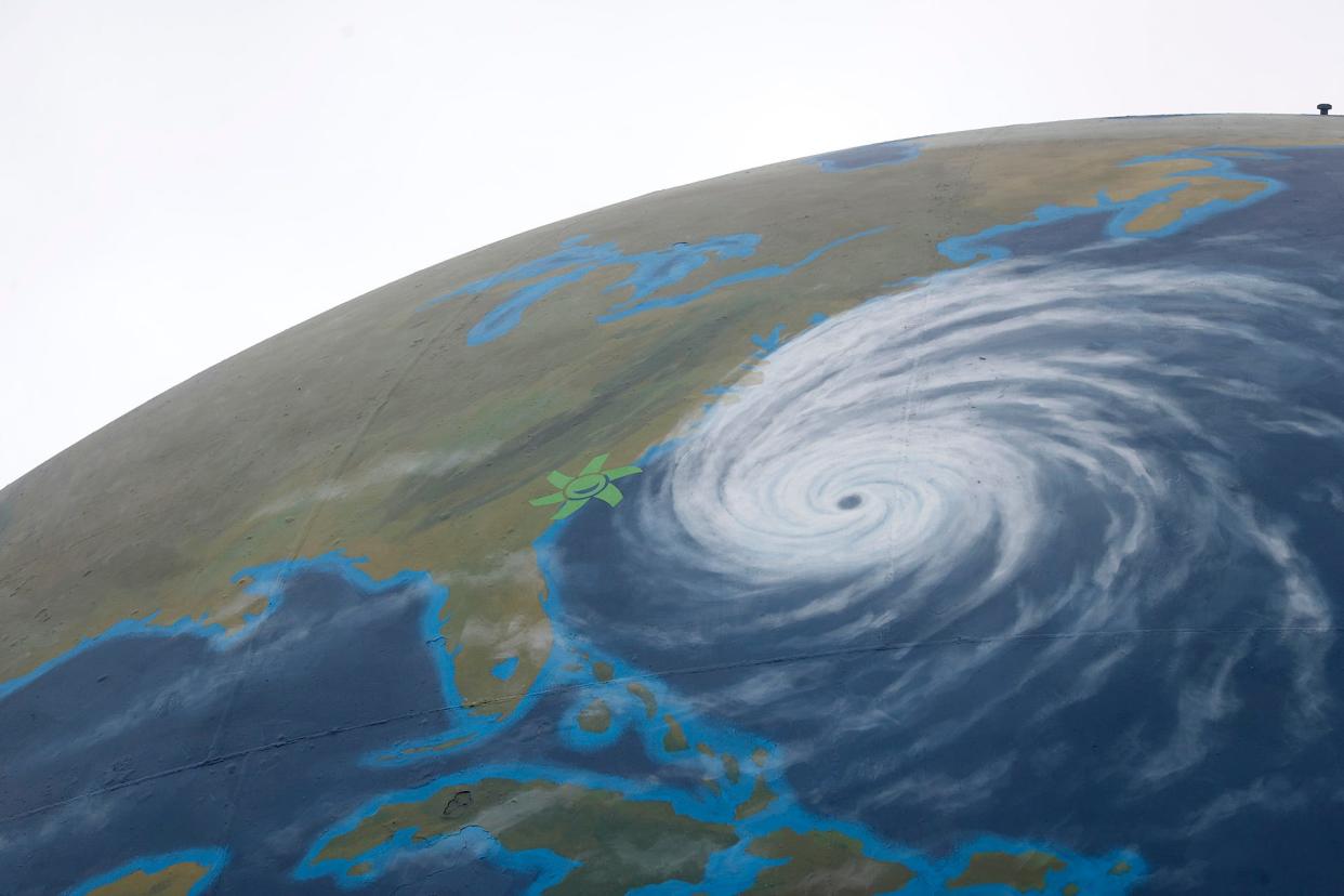
Forecasters are updating hurricane predictions. What does that mean for Savannah?
Ocean surface temperatures are unusually hot. El Niño has arrived. The Atlantic is getting a dose of dry air from the Saharan Desert. While forecasters originally predicted uncertainty in their 2023 Atlantic Hurricane season outlook, they're revising predictions to say the 2023 Atlantic hurricane season won't be as mild as originally predicted.
Forecasters at Colorado State University originally estimates the season would see 15 named storms, including seven hurricanes, three of which could be major.
The National Oceanic and Atmospheric Administration also released its own hurricane season forecast on May 25, anticipating a range of 12 to 17 named storms – those with winds 39 mph or higher. Of those, five to nine could become hurricanes, including one to four major hurricanes (Ctegory 3 or higher).
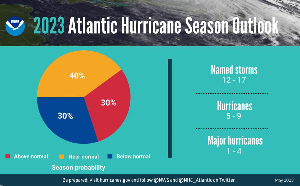
NOAA had a 70% confidence in these ranges, meaning there's a 70% chance the actual number of storms and hurricanes that happen this year will fall within the given range.
But the season hasn't gone as predicted, causing shifts in the estimates. As of early July, CSU predicts 18 named storms this season, of which nine will be hurricanes. Of those nine, four are expected to be major hurricanes with sustained winds of 111 mph or greater.
Get into the weeds: Hurricane season 2023 forecast keeping meteorologists guessing | WeatherTiger
For weather nerds, the updated forecast isn't a shocker. Unlike most years, forecasters at both CSU, NOAA and beyond put a major emphasis on the uncertainty included in this season's forecast. This year forecasters saw the Atlantic move from La Niña, which stirs up conditions ripe for hurricanes, to El Niño, a weather phenomenon that tends to tamp down hurricane potential. However, at the same time, Atlantic sea surface temperatures have become unusually warm, creating fuel for storms.
Enki Research's Chuck Watson, a Savannah-based hazards researcher and hurricane expert, said that those competing factors are contributing to the level of uncertainty in the Atlantic basin.
Read the first forecast: How bad will the 2023 hurricane season be? Why this year's forecast comes with 'large uncertainty'
What are we seeing in the ocean?
Hurricanes need four basic conditions to get rolling: warm water, moisture in the air, air convergence at the surface and divergence at the top. The last two are like a chimney and give a storm the air movement it needs to start turning and growing.
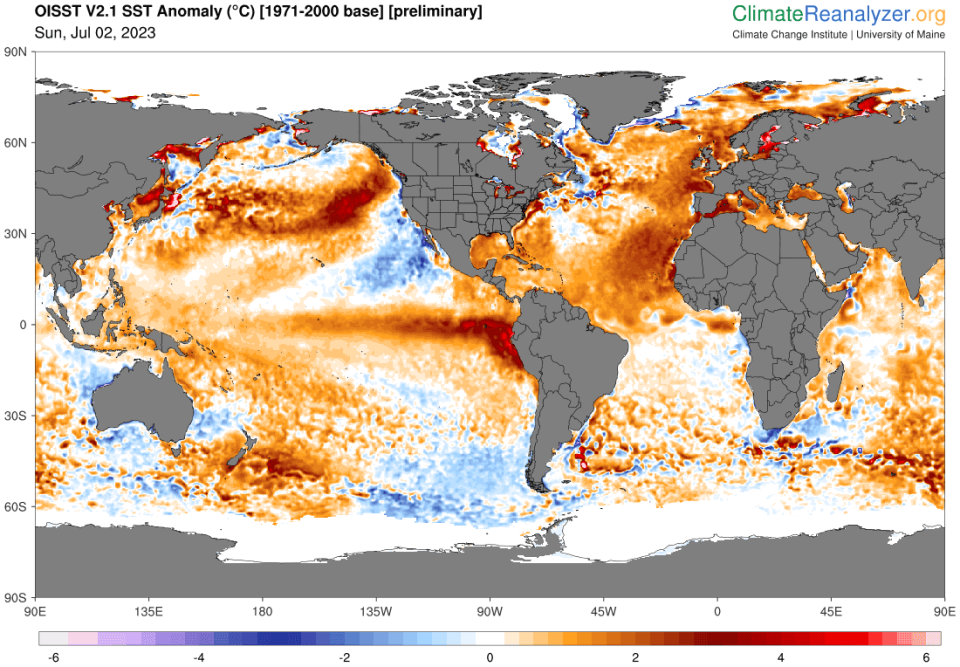
Watson said there are factors enhancing and hindering these conditions. The warm surface water temperatures create good fuel for storms, and according to NOAA roughly 40% of the world’s oceans are experiencing marine heat waves, the most since satellite tracking started in 1991. Many places along the Atlantic are several full-degrees warmer than average, Watson said.
At the same time though, Watson said the way winds are moving with El Niño, any little storms that start to crop up will have their "tops torn off" before they are able to mature.
Dive deeper: The oceans are unusually hot and on track to get hotter. That's not good.
Explained: What is the Saffir-Simpson hurricane wind speed scale? Breaking down the hurricane category scale
Another factor that could detract from hurricane-forming conditions is air from the Saharan Desert. In years before, Savannah residents may have noticed hazy summer skies when the Saharan dust blows over the Atlantic and onto shore, but Watson said when it comes to hurricanes it's not the dust, but the dry desert air that makes a difference. The dry air removes a key piece needed for energy to be converted and a hurricane to ramp up over the ocean, but on television forecasts it is easy to eyeball that dry air when it's filled with dust.
Overall, Watson said the Atlantic is on track to have a pretty average to below-normal hurricane season, even if some of the predicted counts from institutions like CSU have been bumped up.
"The numbers (of storms) aren't really as critical," Watson said. "The main thing is to always prepare every year as if you're going to get hit."
He reminds that there is a 30-day period from when you purchase FEMA flood insurance to when it goes into effect, so it is important to ensure you have flood insurance in advance of Savannah's more active months of the hurricane season in the fall. Regular home insurance won't cover flooding damages.
Even if it is not an active season, it just takes one storm to have challenging financial impacts from a storm.
Why do we care about classification?
Watson said he tries to avoid the numbers game of how many storms there will be in a season and even notes how organizations like NOAA and its National Hurricane Center have changed how storms are categorized and named over the course of decades. He said there are plenty of hurricanes and tropical storms that wouldn't get the same level of categorization as they do now 10, 20 years ago. At the same time, satellite technology for observing and tracking storms has greatly improved.
Whether Savannah gets a 38 mph or 40 mph storm changes classification but climatologically, and for people on the ground, doesn't make a huge difference.
However, he put a big asterisk next to that statement. While the classifications, especially at the margins, don't always mean huge differences in a storm they economically are a big deal. When storms get upgraded, he said, it radically changes the aid that kicks in from federal agencies and insurance. The difference in those two miles per hour, he said, can be life-changing financially as people recover from a natural disaster.
Marisa is an environmental journalist covering climate and the coast. She can be reached at mmecke@gannett.com or 912-328-4411.
This article originally appeared on Savannah Morning News: Updates to hurricane forecast call for slightly more active season

