Hurricane Center watching 4 tropical waves. System moving into Caribbean could strengthen
As the end of August approaches, the Atlantic hurricane season remains abnormally quiet, but forecasters are warning that may change.
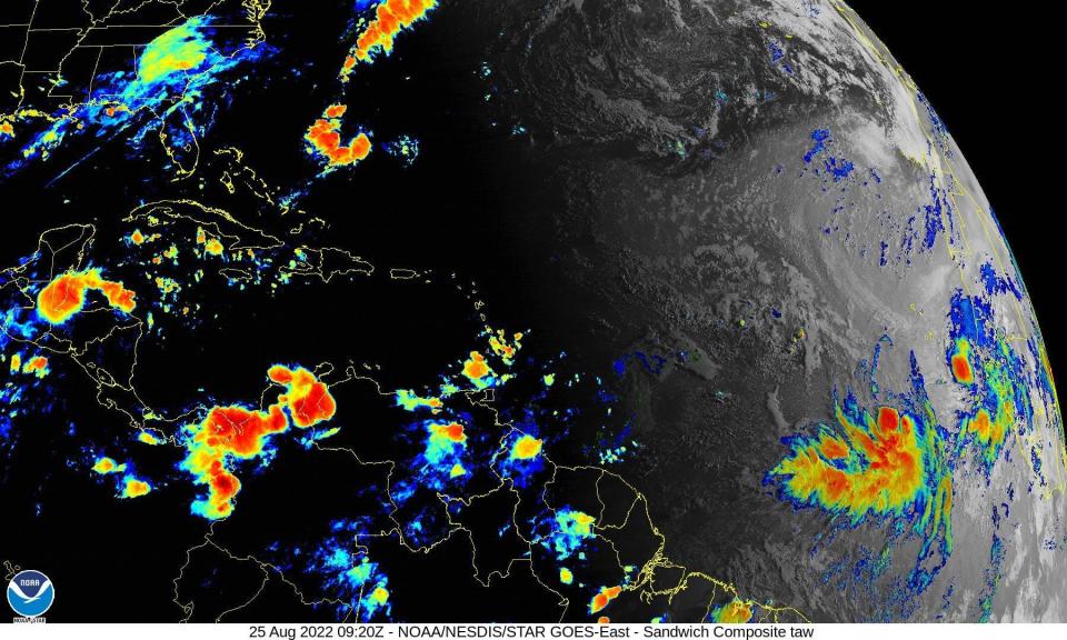
The National Hurricane Center currently is monitoring four tropical waves in the Atlantic basin. Environmental conditions are favorable for possible development over the weekend and going into next week.
One of the tropical waves was moving across the Windward Islands into the Caribbean as of 8 a.m.
► Your guide to preparing for the 2022 hurricane season in Florida
There have been three named storms so far this year in the Atlantic. The last one, Tropical Storm Colin, popped up off the Carolinas over the Fourth of July weekend.
The peak period of the Atlantic hurricane season runs from mid-August to mid-October, and forecasters are picking up signs tropical activity may soon pick up.
"Wind shear has dropped off in a zone from just north of the equator over the Atlantic to the Caribbean Sea this week," AccuWeather Chief On-Air Meteorologist Bernie Rayno said.
"As a tropical wave enters the Caribbean this weekend and into early next week, it will be in a low shear and moistening environment, which could be enough to allow slow development," Rayno said.
Revised seasonal forecast: Atlantic hurricane season off to slow start. But top forecasters still expect above-normal activity
WeatherTiger: Late August to early September hurricane forecast: Finding reason in a slow storm season
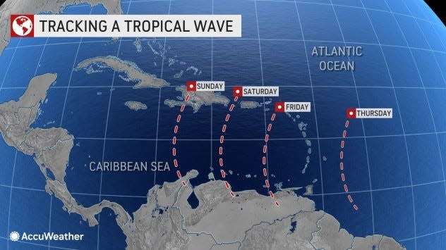
If the wave fails to gain sufficient strength as it moves through the Caribbean, it is more likely to move toward Central America.
However, if it does develop into a tropical depression or storm, it is more likely to take a more northwest or northward turn toward Cuba and then perhaps the United States, according to AccuWeather.
Here's the latest update from the NHC as of 2 a.m. Aug. 25:
What's out there and where are they?
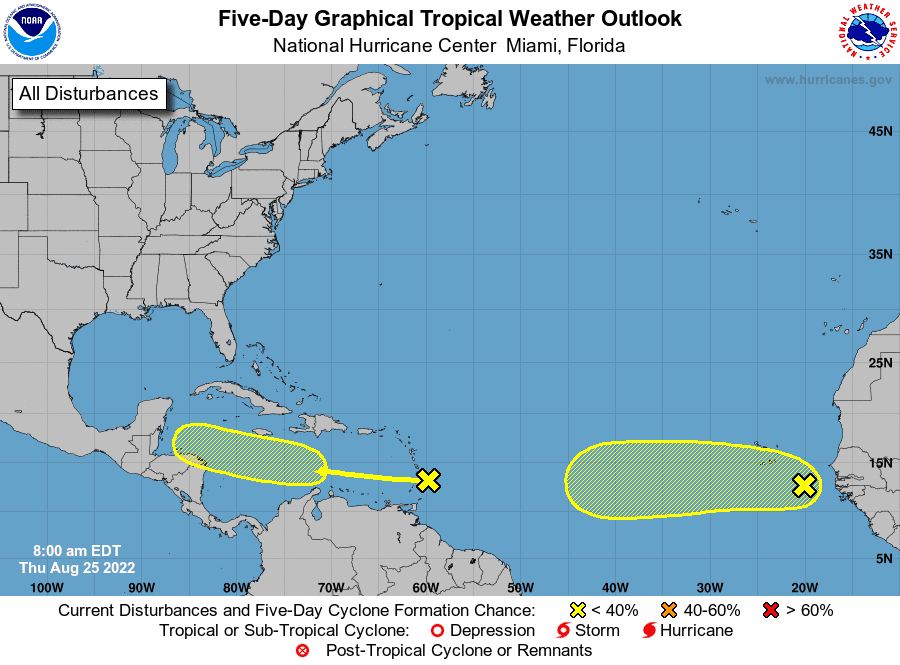
Tropical wave 1: A well-defined tropical wave is moving across the Windward Islands while producing disorganized showers and thunderstorms.
Tropical wave 2: A tropical wave has moved off the west coast of Africa and is producing a large area of disorganized showers and thunderstorms.
Tropical wave 3: A tropical wave in the central Atlantic is located between Cape Verde and Barbados. It's moving to the west at 11 mph. Showers are limited due to a dry air.
Tropical wave 4: A tropical wave is located along the Yucatan Peninsula in the western Caribbean. It's moving to the west at 5 mph. Showers and thunderstorms are impacting the eastern Bay of Campeche.
How likely are they to strengthen?
Tropical wave 1: This system is expected to move west at about 15 mph during the next several days, and environmental conditions could become more conducive for slow development when it moves across the central and western Caribbean Sea early next week.
Formation chance through 48 hours: low, near 0 percent.
Formation chance through 5 days: low, 20 percent.
Tropical wave 2: Environmental conditions could support some slow development of this system through early next week while it moves quickly west across the eastern and central tropical Atlantic at 15 to 20 mph.
Formation chance through 48 hours: low, 10 percent.
Formation chance through 5 days: low, 20 percent.
Who is likely to be impacted?
It's too early at this time to determine if there will be any impact to the U.S. from the tropical waves.
Early predictions: CSU, AccuWeather forecasters agree: Active hurricane season ahead. Here's what you need to know
Forecasters urge all residents to continue monitoring the tropics and to always be prepared during what's expected to be an active hurricane season.
Colorado State University's 2-week forecast for Aug. 18-31
CSU has issued 2-week Atlantic #hurricane forecast (Aug. 18-31) and gives highest odds for near-normal activity (70%) with below-normal & above-normal both given 15% chances. Tropical cyclone activity is likely to increase later in the period:https://t.co/8GXmlarsze pic.twitter.com/ID9ZEHYIfG
— Philip Klotzbach (@philklotzbach) August 18, 2022
Meteorologists forecast normal hurricane activity over the next two weeks, with a 15% chance of above-normal activity and a 15% chance of below-normal activity.
Tropical cyclone activity is likely to increase later in the period.
When is the Atlantic hurricane season?
The Atlantic hurricane season runs from June 1 through Nov. 30.
When is the peak of hurricane season?

Although the season has gotten off to a quiet start, the peak of the season is Sept. 10, with the most activity happening between mid-August and mid-October, according to the Hurricane Center.
Weather watches and warnings issued for your area
If you can't see any local weather warnings here, you'll need to open this story in a web browser.
The next five days
See the National Hurricane Center's five-day graphical tropical weather outlook below.
Excessive rainfall forecast
What's out there?
Systems currently being monitored by the National Hurricane Center.
What's next?
We will continue to update our tropical weather coverage daily. Download your local site's app to ensure you're always connected to the news. And look at our special subscription offers here.
This article originally appeared on Palm Beach Post: Tropics watch: Atlantic activity increasing. Trackers watching 2 systems

