Flash flood warning expires, but flood warning remains: What we know
Fort Collins and other portions of Larimer County were under flash flood warnings Sunday as heavy rain hit the area, with some areas under a flood warning into early Monday morning.
And more storms are expected Monday, prompting the National Weather Service to issue a flood watch starting at 10 a.m. Monday.
Here's what we know as of 3 p.m., Monday:
Burn scar flash flood warning expires
The National Weather Service has ended its flash flood warning for the Cameron Peak Fire burn scar in central Larimer County, as heavy rain in the area has ended and flooding is no longer expected to pose an imminent threat.
Motorists should heed any posted road closures and be aware that a flood watch remains in effect across Larimer County and much of Northern Colorado until midnight.
As of 2 p.m. Monday, the Poudre River in Fort Collins was running below 6 feet, well below its flood action stage of 8.5 feet and minor flood stage of 10 feet. The river was running at similar height at the canyon mouth, but had crested to action stage downriver near Greeley.
— Eric Larsen
Flood advisory indicates heavy rain in part of Fort Collins
The National Weather Service issued a flood advisory for Larimer County, warning of expected urban and small stream flooding. According to radar, heavy rain is falling, with between 1 to 1.5 inches of rain having fallen already and another half an inch to inch of rain expected.
The advisory is in effect until 2:45 p.m. Monday and includes portions of Larimer, Boulder and Jefferson counties.
Flooding is expected in these specific locations:
Southern Fort Collins
Loveland
Berthoud
Northwestern Arvada
Western Westminster
Boulder
Longmont
Southwestern Broomfield
Lafayette
Louisville
Superior
Lyons
Niwot
Carter Lake
Crisman
Cedar Cove
Eldorado Springs
Masonville
Rocky Flats
Hygiene
— Sarah Kyle
Flash flood warning called for Cameron Peak Fire burn scar
Heavy rains on the Cameron Peak Fire burn scar in central Larimer County have forced the National Weather Service to issue a flash flood warning for the area until 3:15 p.m. Monday. Rainfall of up to 2 inches is expected in the warned area, and flash flooding is occurring or is expected to begin shortly, according to the NWS.
Flash flooding on the Poudre River is expected near Rustic and areas to the west. Anyone in the flood area should seek higher ground.
Flash Flood Warning for Cameron Peak Burn Scar until 315 pm MDT. #cowx pic.twitter.com/FYQDGjowM0
— NWS Boulder (@NWSBoulder) June 12, 2023
Fort Collins and the rest of Larimer County remain under a flood watch until midnight, with a flood advisory in effect for portions of the Poudre River in Larimer and Weld counties, especially between Windsor and Greeley.
— Eric Larsen
Flood watch extended to more areas of Colorado
The flood watch issued for Larimer County and other portions of Colorado Monday has been updated. The watch is in effect through midnight and now includes:
In north-central Colorado:
Larimer County below 6,000 feet
Northwest Weld County and Larimer and Boulder Counties between 6,000 and 9,000 feet
In northeast Colorado:
Boulder and Jefferson counties below 6,000 feet
West Broomfield County, central and east Adams and Arapahoe counties, central and south Weld County, Elbert/central and east Douglas counties above 6,000 feet
Logan County, Morgan County, north Douglas County below 6,000 feet/Denver/West Adams and Arapahoe counties/east Broomfield County, northeast Weld County and Washington County
In central Colorado:
Jefferson and west Douglas counties above 6,000 feet
Gilpin/Clear Creek/northeast Park counties below 9,000 feet
In east central Colorado:
North and northeast Elbert County below 6,000 feet
North Lincoln County and southeast Elbert County below 6,000 feet
South Lincoln County
See the full alert from the weather service here.
— Sarah Kyle
What should I do to prepare for possible flooding?
Here are action steps the weather service recommends in preparation for Monday's heavy rain:
Monitor forecasts later Monday and keep an eye out for flood warnings.
Be prepared to take action if you live in an area that's prone to flooding.
"Turn around, don't drown" if you come across a road that's flooded, as the bulk of flood-related deaths happen in vehicles.
Be aware of your surroundings and, again, don't drive on flooded roads.
Move away from areas that have been recently burned, as "life-threatening flooding of creeks, roads and normally dry gulches is possible. Heavy rains may trigger rockslides, mudslides and debris flows in steep terrain."
— Sarah Kyle
Rain totals as of Monday morning
One recording station in Windsor reported the highest rain total of 4.26 inches. The highest mark in Fort Collins was 3.29 inches in the southern section of the city.
Fort Collins has received at least a trace of rain all but one day in June through Sunday with much more rain forecast for Monday.
The city reported 1.07 inches of rain Sunday at its official weather station on CSU's main campus. The city averages 1.90 inches of rain in June but has already recorded 3.95 inches.
— Miles Blumhardt
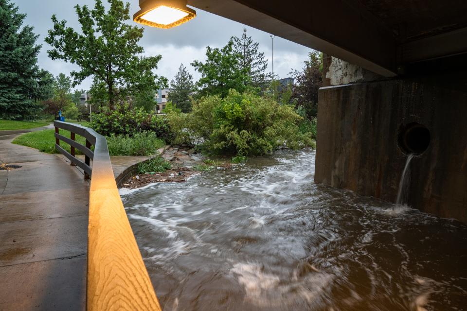
Spring Creek running high through Edora Park
Spring Creek was running high through Edora Park Monday morning. Here's a look at it:
— Sarah Kyle
Additional storms, rains expected Monday; flood watch issued
Larimer County is under a flood watch from 10 a.m. Monday until midnight.
The National Weather Service forecast calls for more showers and thunderstorms in the Fort Collins area Monday, with showers and thunderstorms expected before 1 p.m., "possibly a thunderstorm" between 1-3 p.m. and more, you guessed it, showers and thunderstorms after that.
Monday's storms could produce heavy rain, and some areas of eastern Larimer and Weld counties "will be extremely susceptible to flooding" after Sunday's storm, the weather service said in the flood watch.
Here are the areas impacted by that watch:
Larimer and Boulder counties between 6,000 and 9,000 feet
Larimer County below 6,000 feet
Northwest, northeast, central and south Weld County
Morgan County
Logan County
Washington County
During stronger storms in that area, the weather service expects rainfall rates of up to an inch in 30 minutes or less.
"You should monitor later forecasts and be alert for possible Flood Warnings. Those living in areas prone to flooding should be prepared to take action should flooding develop. Turn around, don't drown when encountering flooded roads. Most flood deaths occur in vehicles."
— Sarah Kyle
How do I get emergency alerts about flooding in Larimer County?
Text LCFLOODS to 888777. You can also visit www.nocoalert.org to see a map of the area (we've embedded that map earlier in this story, too).
— Sarah Kyle
More: Signing up for these Larimer County emergency alerts could save your life
Thunderstorms, heavy rain prompt flood warnings for Larimer County
Heavy rain hit Fort Collins Sunday evening, with up to 2.5 inches of rain having fallen in the National Weather Service's warning area as of about 7:30 p.m., according to an emergency alert. The flash flood warning in effect until 10:30 p.m. Sunday included:
Fort Collins
Northeastern Loveland
Windsor
Wellington
Timnath
Small creeks and streams, gulches, roads and poor drainage and low-lying areas could be impacted by flash flooding, the weather service warned at the time.
Later Sunday night, the weather service issued a flood warning for north central Larimer County, including:
Windsor
Severance
Timnath
New Windsor Reservoir
In that warning, which was in effect until 4:30 a.m. Monday, the weather service said "flooding of rivers, creeks, and other low-lying areas and flood-prone locations is imminent or occurring. Streams continue to rise due to excess runoff from earlier rainfall."
If you encounter a flooded road, do not try to drive through it.
— Sarah Kyle
Fort Collins put on accident alert Sunday
Though we typically see accident alert status during winter weather, Fort Collins police issued one for Sunday's heavy rainfall.
Accident alert status was in effect until about 10 p.m. Sunday.
Here's what to do when we're under an accident alert: If you're involved in a minor crash without injury, impairment, a noninsured vehicle or vehicles that can't be moved in Fort Collins, exchange information with the other driver(s) and make an accident report at https://www.fcgov.com/police/coplogic-start-report.
— Sarah Kyle
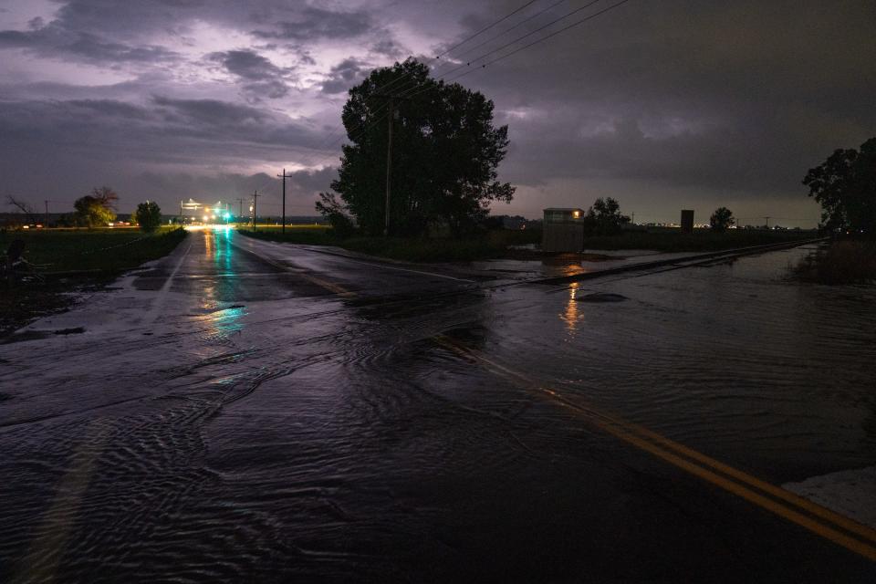
Carpenter Road 'impassable' as flooding impacted portion of road
Carpenter Road, or Colorado Highway 392, was "impassable" between Greenstone Trail and Timberline Road, Fort Collins police said in a tweet around 8:30 p.m. Sunday.
"This is expected to be this way for some time due to rainfall," police said.
The road was expected to reopen late Sunday night, police said in a later tweet.
— Sarah Kyle
What should I do if a road is flooded?
"Turn around, don't drown when encountering flooded roads," according to the weather service. "Be aware of your surroundings and do not drive in flooded roads."
— Sarah Kyle
Wasn't Lil Jon supposed to perform at Taste of Fort Collins Sunday?
Yes, Lil Jon was Sunday night's headliner at the Fort Collins food and music festival. However, rain prompted a festival delay about 30 minutes before the show was set to start, Coloradoan visual journalist Lucas Boland reported.
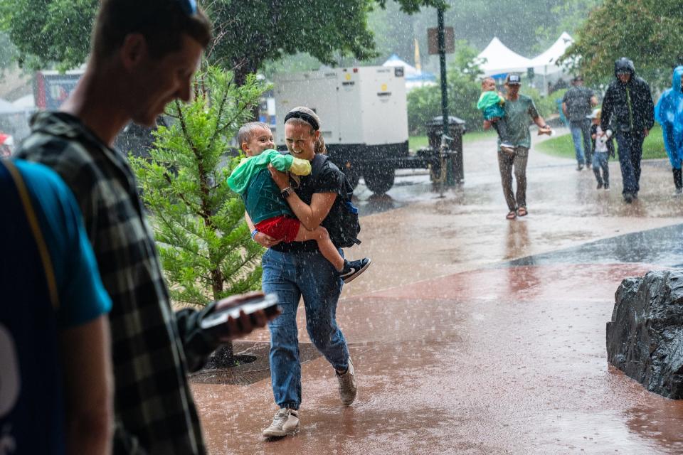
Organizers had hoped reopen gates at 8:15 p.m. for an 8:30 p.m. show, but ultimately canceled the concert "due to severe weather with lightning in the area," according to an event notification.
"Please seek shelter," the notification advised.
— Sarah Kyle
More: Lil Jon concert canceled as heavy rains hamper Taste of Fort Collins
This article originally appeared on Fort Collins Coloradoan: Flooding, heavy rain in Fort Collins, Larimer County: What we know

