Fort Collins weather quickly changing from hot and dry to chilly and rainy
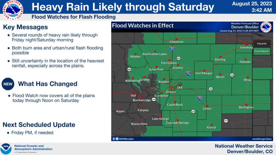
Fort Collins and a large portion of northeast Colorado are under flood watch from 9 a.m. Friday through Saturday morning, according to the National Weather Service.
Several rounds of heavy rain are expected in the watch area, the heaviest of which could produce flash flooding.
As of Friday morning, the weather service still was unsure where the heaviest rain, which could exceed 3 inches, was to be expected.
If you're planning outdoor outings Friday and Saturday, you will want to pay close attention to a forecast calling for major changes in temperature and precipitation.
Here is what we know regarding the incoming weather system, according to the National Weather Service in Boulder:
Here is how drastic of a change Fort Collins will see Thursday to Friday
Thursday: 92 degrees and sunny
Friday: 66 degrees and a 90% chance of rain, potentially heavy
Ingredients behind big weather change to create perfect storm in Fort Collins area
Remnants of Tropical Storm Harold providing the moisture
Strong cold front providing unstable atmosphere
Upslope conditions anchoring slow-moving storms
Despite moisture levels in the atmosphere rarely seen in our area associated with this system, the unknown ingredient remains lift, which is needed to generate precipitation.
Reliable sources of lift are forecast to be available. Where the most lift and most upslope occur is where "slow-moving, efficient rain producers'' will be found.
Timing of the storm to help minimize flash flood danger, outdoor interruptions
Friday: Showers and thunderstorms starting in the afternoon through early Saturday throughout the Fort Collins area. High-risk flash flood areas include burn scars, east slope canyons and the Interstate 25 urban corridor.
Friday: Flash flooding in the Cameron Peak Fire burn scar rated significant, the highest of four designations.
Saturday: Lower risk of flash flooding but scattered afternoon thunderstorms producing locally heavy rainfall possible.
How much rain is Fort Collins and the surrounding area expecting from the storm?
Here are the National Weather Service's forecast amount of rain Friday through Saturday:
Fort Collins: 2.24 inches. Adjusted to 1.59 inches Friday morning.
Cheyenne, Wyoming: 1.91 inches
Greeley: 1.52 inches
Boulder: 1.43 inches
Red Feather Lakes: 1.35 inches
Estes Park: 1.26 inches
Denver/DIA: 0.90 inches
How sure is the National Weather Service of its rainfall forecast?
Rainfall rates and amounts and the location of the heaviest rain are still uncertain.
Models continue to increase weather service confidence of a potentially significant event.
The model as of Thursday morning showed a 50% chance of rainfall exceeding 1 inch from noon Friday to noon Saturday, roughly from Fort Collins to Castle Rock, east to Weld and Morgan counties, and across the foothills of Larimer, Boulder and Jefferson counties.
Confidence is a little higher for larger amounts of rain for the northern foothills from Boulder north to Wyoming and extending east to Weld County.
Fort Collins forecast Friday through the weekend
Friday: 90% chance of rain with showers and possibly a thunderstorm after 1 p.m. into overnight. Steady temperature around 66 degrees, north wind 10 to 14 mph, gusting to 21 mph, and then changing to the northeast after midnight.
Saturday: 80% chance of showers and possibly a thunderstorm from 7 a.m. into the late night. High near 72 degrees. Light northeast wind becoming east-southeast 5 to 10 mph in the morning, gusting to as high as 15 mph.
Sunday: 60% chance of showers and possibly a thunderstorm after 1 p.m and through early evening. High near 83 degrees.
This article originally appeared on Fort Collins Coloradoan: Fort Collins weather: Big change coming Friday into weekend

