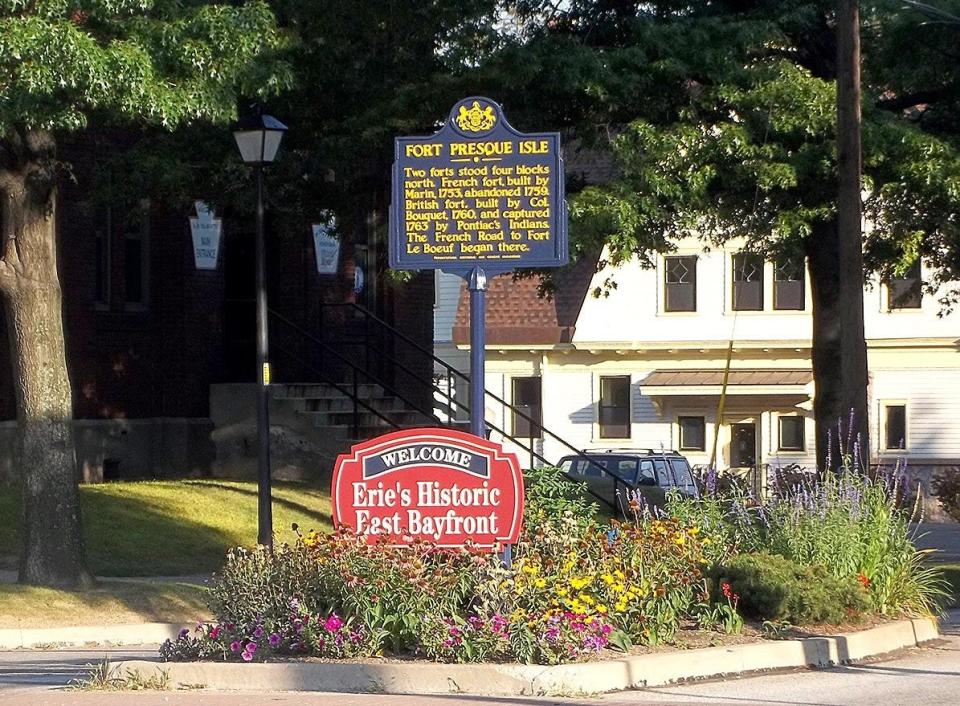
Fort Presque Isle to Fort LeBoeuf: The history of the first known road in Erie County
- Oops!Something went wrong.Please try again later.
Before any roads were built on Presque Isle, there were only rough paths made by Native Americans. These were narrow footpaths because the Iroquois and Eriez usually did not use horses for travel. Their paths were unimproved dirt that could be muddy or flooded in rainy weather.
Over time, new-growth trees developed on the paths, making travel quite a problem. When the first settlers arrived in northwestern Pennsylvania, they found that the paths were only wide enough for one horse or horse and cart. The settlers soon found these dirt paths inexpensive to expand, but they were sometimes still impassable. In winter, the roads were easier to traverse, so they used sleds instead of wagons.
Erie-area history: The American Revolutionary War and northwestern Pennsylvania
In 1753, Michel-Ange Du Quesne de Menneville, Marquis Du Quesne, the governor of New France, ordered a French force to construct a series of forts leading to the Ohio River Valley. The first French fort site was located at Presque Isle. When built, it was located on the western bank of what became known as Mill Creek. A detachment of French soldiers quickly occupied the fort. They were then assigned to build a road to Le Boeuf, which is Waterford today. This was the first road in the area and ran from Fort Presque Isle south to Le Boeuf.
Erie's earliest days: The building of the French fort at the harbor
The route chosen was rough and hilly, yet also the most practicable. There were areas through marshes and across small streams. The French would cut small tree trunks to use in the wet areas and lay them close together across the roadway. This made it dry and solid. However, this part of the road had a corduroy quality and was quite rough. When the settlers moved into the area, they used the same route with minor changes around these wet areas.
In August 1753, the French commander of the fort sent word to Du Quesne that the fort at Presque Isle was finished and the portage road to Le Boeuf was ready for wagon traffic. The road had a large storage house at its midway point, and was six leagues in length. This term was a unit of measure at the time. Unfortunately, it can mean anywhere from 2.4 miles to 4.6 miles depending on who was doing the measuring. That meant the road could have been either 14.4 miles or 27.6 miles today. In actuality, those two points are about 15 miles apart.
Judah Colt was hired by the Population Company, which owned the land in the area. He became the only land agent and sold land to new settlers. After a few years, Colt established Colt Station in 1797 at Greenfield Township. That same year, he built a road to Colt Station as a supply route from Lake Erie. Goods soon traveled by ship from Buffalo, New York, to Erie at the Sixteen-mile Creek, where Colt had built a dock. Goods were transported overland to Colt Station. He extended the road in early 1798 to French Creek, where he established a boat landing. He then continued the road to the forks of the creek at Wattsburg later that same year. This road was the first one built after the American occupation of the area.
Finally, in 1802 or 1803, the commonwealth built a road from the headwaters of the Delaware River to Ohio. Back then, it was known as the State Road. It is hard to determine if that information is 100% correct because the Erie Court House burned down and all records were lost. Over the next 15 or 20 years, many other roads were constructed because the population of the Erie area was expanding and traffic through the port was growing by the day.
More: Before he led the U.S. victory on Lake Erie in 1813, Oliver Hazard Perry crossed it by ice
Gene Ware is the author of 10 books. He serves on the board of the Presque Isle Light Station and is past chairman of the boards of the Tom Ridge Center Foundation and the Presque Isle Partnership. Email him at ware906@gmail.com.
This article originally appeared on Erie Times-News: History of Erie County's first road, Fort Presque Isle to Le Boeuf

