Fort Worth weather: Severe thunderstorm watch over; tennis-ball sized hail reported Friday

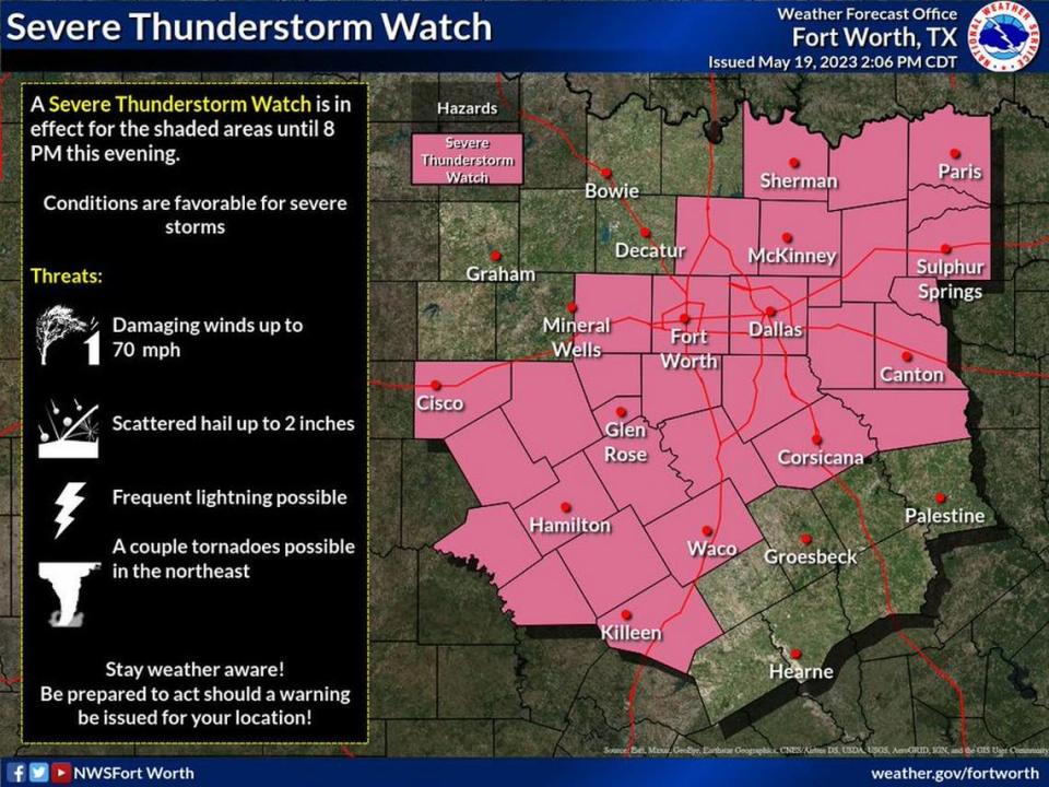
A severe thunderstorm watch issued by the National Weather Service has expired across portions of North and Central Texas. It was previously in effect until 10 p.m.
The NWS alert states the main causes for concern were wind gusts that can be as strong as 70 mph and hail of up to 2 inches in diameter.
“Make sure to have multiple ways to receive warnings and stay weather aware!” the alert states. The watch includes Tarrant and Dallas counties and others in the Dallas-Fort Worth area.
The storm watch area is along and 65 miles east and west of a line from 40 miles northeast of Dallas to 55 miles west of Waco, according to the NWS.
“A Severe Thunderstorm Watch means conditions are favorable for severe thunderstorms in and close to the watch area,” according to the NWS. “Persons in these areas should be on the lookout for threatening weather conditions and listen for later statements and possible warnings. Severe thunderstorms can and occasionally do produce tornadoes.”
Weather watches and warnings
A live data feed from the National Weather Service containing official weather warnings, watches, and advisory statements. Tap warning areas for more details. Sources: NOAA, National Weather Service, NOAA GeoPlatform and Esri.
Storms began in mid-afternoon and continued in North Texas in the evening, said Steve Fano, a meteorologist at the NWS Fort Worth office. Storms and a cold front are expected to bring the temperature down to the mid-60 degrees on Friday.
A severe thunderstorm that moved through eastern Tarrant County in the late afternoon included penny and dime sized hail near Grapevine and Euless, according to reports sent from storm spotters to the weather service.
Later storms in Collin County dropped even larger hail in the Allen area with stones measuring as big as golf balls and tennis balls.
@wfaaweather golf ball-baseball size hail in Allen. Two cars are goners at our house. Rest of neighborhood has much damage pic.twitter.com/M3RVDPZrJ0
— Jessica Doublesin (@jdoubs1) May 20, 2023
@wfaaweather my parents in Allen sent this to me from the storm earlier pic.twitter.com/jQUjvjKsu2
— Connor (@_ConnorNelson_) May 20, 2023
Here’s everything we know about Friday’s storm:
When are storms expected to hit North Texas?
The storms started to hit North Texas around 4 p.m., and may continue for a few hours.
Between 6 and 9 p.m. is when rain and damaging winds are expected, Fano said. After around 10 p.m., the cold front and storms should move southward.
“It’s not gonna rain all night long, but there will definitely be a few hour window where we’ll have potential to see some of those strong severe storms,” Fano said.
Storm Reports
This map contains continuously updated storm reports and damage from the National Weather Service for the past 48 hours. Reports include tornado, wind storm and hail storm reports. The map also includes tornado reports for the past week and recent rainfall accumulations. Sources: National Oceanic and Atmospheric Administration (NOAA), Esri.
Is there a chance of a tornado from these storms?
Not with this storm, but there’s always a chance this time of year.
Friday’s storm doesn’t look like it will bring any type of tornado or flooding threats, Fano said. However, since severe weather season begins in March and ends in June for North Texas, the possibility is never zero.
“I would like to preface by saying that this time of year, especially even though the tornado threat is low, it’s never zero,” Fano said.
What’s the forecast for the rest of the weekend?
After Friday’s severe weather storms, the rest of the weekend will be pleasant and slightly chilly.
The cold front bringing the storms to North Texas will also bring mid-60 degree temperatures Saturday morning, then warming up to about 78 degrees, Fano said. Sunday’s weather will almost mirror Saturday’s with mid to high 70 degrees and clear skies.
Rain chances don’t return to the forecast until Tuesday of next week, Fano said.
3-Day Storm Outlook
This map shows the 3-day weather outlook for storms by the National Weather Service's Storm Prediction Center. Sources: National Weather Service, Esri.
Current Temperatures
Current temperatures and weather data from NOAA weather stations updated hourly. Tap on the map for current weather conditions, including humidity, wind speed. and direction. Data provided by NOAA and Esri.
