Fourth of July weekend sees near record-high temps in Bradenton. Here’s the forecast
Heat is nothing new to Florida, and the start of the summer season has delivered a lot of it.
With the Fourth of July holiday nearing, Bradenton-area residents who plan to go to the beach, host cookouts or participate in other activities this week should be aware of heat-related illnesses and deaths among Florida’s youth.
High temperatures have weather forecasters double-checking their record books in comparison to how high temperatures will increase over the weekend.
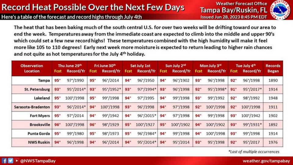
The National Weather Service published a chart Thursday showing how the weekend forecast in the Tampa Bay area, including Bradenton and Sarasota, is approaching record-high temperatures.
Inland temperatures in Bradenton are expected to reach the mid-to-upper 90s but will feel like 105 to 110 degrees. Forecasters predict that more rain will flow into the area early next week, possibly cooling things down for the July 4 holiday.
Bradenton weekend weather forecast
Saturday: Sunny and hot, with a high near 97. Heat index values as high as 105. East wind 6 to 9 mph becoming north-northwest in the afternoon.
Saturday Night: Mostly clear, with a low around 78. Northwest wind around 7 mph becoming southeast after midnight.
Sunday: Scattered showers and thunderstorms after 2 p.m. Sunny and hot, with a high near 95. South wind 5 to 9 mph becoming west in the afternoon. Chance of precipitation is 40%.
Sunday Night: Scattered showers and thunderstorms, mainly before 8 p.m. Mostly clear, with a low around 78. West wind 5 to 7 mph. Chance of precipitation is 30%.
Monday: Scattered showers and thunderstorms, mainly after 2 p.m. Sunny and hot, with a high near 95. West wind 5 to 10 mph. Chance of precipitation is 50%.
Monday Night: Scattered showers and thunderstorms before 2 a.m. Partly cloudy, with a low around 78. West wind 6 to 10 mph. Chance of precipitation is 30%.
Tuesday: Scattered showers and thunderstorms between 8 a.m. and 2 p.m., then showers likely and possibly a thunderstorm after 2 p.m. Mostly sunny and hot, with a high near 96. North wind 5 to 10 mph becoming west in the afternoon. Chance of precipitation is 60%.
Staying safe in hot weather
According to the NWS, heat is one of the leading causes of weather-related death in the United States, killing hundreds each year. Heat exhausts the body, and pregnant women, children and the elderly are more affected by heat-related illnesses.
Your body’s ability to stay cool is put to the test under hot and humid conditions, the NWS said. When the body heats up too quickly to effectively cool itself, or when too much fluid or salt is lost by dehydration or sweating, body temperature increases, which could bring on some heat-related sickness.
The Centers for Disease Control and Prevention shared a list of heat-illness warning signs and symptoms, as well as first-aid advice. In general, people should watch out for muscle cramps, dizziness, heavy sweating and nausea while experiencing extremely hot weather.
The Florida Department of Health recommends sticking to the shade, staying hydrated and wearing sunscreen. If a person begins to throw up or symptoms last longer than one hour, seek medical help immediately.
Over the holiday, parents and caregivers should also keep a watch on toddlers and children in hot cars. A toddler or young child can die in a hot car in 10 minutes, according to NoHeatStroke.org.
Between 1998 and 2022, Florida had 105 children die from vehicular heat stroke, behind Texas, which had 138 deaths, the website reported. In the past 25 years, 938 children in the U.S. have died as a result of vehicular heat stroke.

