Freeze Warning for areas of the Miami Valley; First flakes of season possible tomorrow
A Freeze Warning has been issued for Butler, Clinton, Darke, Greene, Montgomery, Warren, and Wayne (IN) Counties from 10 p.m. Monday until 10 a.m. Tuesday.
A Freeze Watch has been issued for Auglaize, Champaign, Clark, Logan, Mercer, Miami, and Shelby Counties from 10 p.m. Monday until 10 a.m. Tuesday.

QUICK-LOOK FORECAST:
Freeze warning for some tonight
First flakes of the season possible
Dry, warmer to end the week
>> TRACK THE CONDITIONS WITH LIVE DOPPLER 7
DETAILED FORECAST:
TODAY: Scattered clouds around this evening and through the night, according to Storm Center 7 Chief Meteorologist McCall Vrydaghs. Still a bit breezy and turning cold! Temperatures will fall below freezing in most spots.

Any sensitive plants or pumpkins should be brought indoors if possible. Also, as winds remain out of the northwest, some light mix to snow showers will be possible. No accumulation is expected.
TUESDAY: A cloudy, windy and cold day. Light showers will swing through off and on through the day. Early morning some wet flakes may mix in across the north and west.

Temperatures will struggle to warm up and will only reach a high in the middle to upper 40s. A few more passing mix to snow showers possible across the northern Miami Valley Tuesday night with lows back down into the lower 30s.

WEDNESDAY: A bitterly cold morning in the low 30s. Clouds will decrease for sunshine throughout the day. Highs around 50. Still a bit breezy.
THURSDAY: A chilly morning around freezing. Sunshine through the day but cooler than normal with highs in the middle 50s.
FRIDAY: A quiet end to the week. Dry and sunny. Highs in the middle 60s which is back to normal.
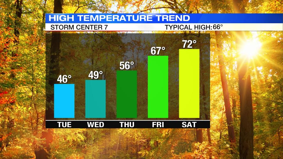
SATURDAY: A beautiful weekend! Mostly sunny and warm. Highs in the low 70s.
SUNDAY: A great end to the weekend. Still dry and sunny. Highs in the low 70s.
MONDAY: Mostly sunny to partly cloudy skies. Another warm day with highs in the lower 70s.

