Freezing rain falling in the Midlands as temperatures drop during winter storm
Freezing rain greeted Columbia-area residents Sunday morning, as temperatures dropped across the Midlands.
The rain began Saturday night, and within hours the precipitation turned into sleet and freezing rain in some areas, according to the National Weather Service.
Depending on the temperature, the freezing rain could continue through the afternoon, National Weather Service meteorologists said in a winter weather briefing.
Light snow still remains a possibility in the Midlands, but any accumulation will be less than an inch and is not expected to have any significant impacts, according to the briefing.
That is not the case with the freezing rain, which could cause ice to build up, especially in the northern portion of the Midlands.
The freezing rain is forecast to affect the Columbia and Lexington areas through 11 a.m., the weather service briefing said. Up to a quarter-inch of ice could build up in the Columbia area, according to the briefing.
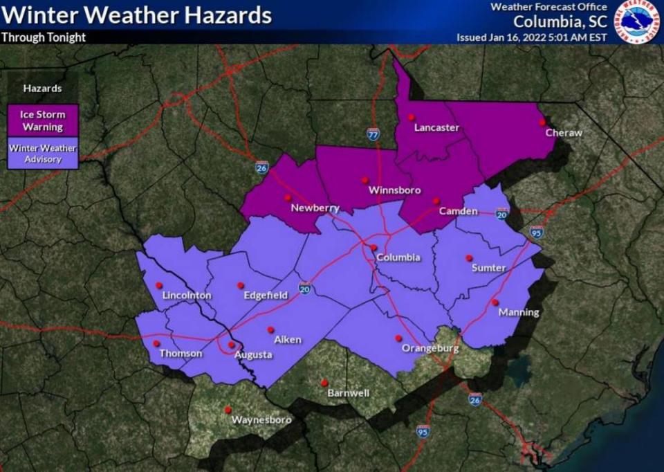
While a winter weather advisory is in effect for the Midlands through 4 p.m., an ice storm warning has been issued for much of Newberry, Fairfield, Kershaw and Lancaster counties.
The freezing rain in those counties is expected to continue through 1 p.m., according to the briefing. Half an inch of ice accumulation is possible in the northern parts of the Midlands.
Conditions will be further complicated by strong wind gusts, some as powerful as 30 mph, according to the National Weather Service. A lake wind advisory has been extended through 10 a.m. Monday.
The winds could be more powerful in the southern portions of the Midlands, reaching 35-40 mph, as areas to the north face a greater threat from ice and freezing rain.
Both strong gusts and ice accumulation could cause considerable damage to trees and branches, which creates the likelihood of downed power lines and outages. As of 8 a.m., more than 32,000 power outages had been reported across South Carolina.
Ice and snow could cause hazardous travel conditions for drivers. That includes the specter of black ice, which could form on roads, especially bridges and overpasses, according to the briefing. Areas in the northern Midlands could have “nearly impossible road conditions,” the National Weather Service said.
“Driving conditions are quickly deteriorating as the storm intensifies,” the South Carolina Department of Transportation said. ️”Please avoid traveling.”
Temperatures will drop across much of the Midlands Sunday night, possibly causing re-freezing of wet roads with a greater concern of black ice on Monday morning.
Rain could continue in the Columbia area through 8 p.m., but temperatures are expected to be above freezing most of the day, reaching a possible high of 43 degrees, according to the forecast. A low of 34 is predicted overnight in Columbia, as winds weaken and there’s a 20% chance of rain.
This is a developing story, check back for updates.

