Friday recap: Hurricane Lee set to bring high winds, coastal flooding to Cape Cod
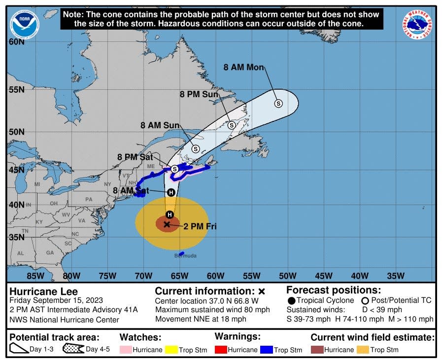
Hurricane Lee is expected to pass to the east of Cape Cod late Friday night into Saturday morning. A Tropical Storm Warning has been issued for the region, with 30 to 40 mph winds and gusts up to 60 mph. Winds are expected to be strongest over the Outer Cape.
A Coastal Flood Warning has been issued for Cape Cod, in effect from midnight on Friday to 2 p.m. on Saturday. According to the National Weather Service, one to two feet of inundation above ground level is possible in low-lying areas near shorelines and tidal waterways.
A High Surf Advisory has also been issued for Cape Cod, in effect until 8 a.m. Sunday. Large breaking waves of five to 27 feet are possible in the surf zone. Dangerous swimming and surfing conditions are predicted and localized beach erosion is possible.
The track and timing of the storm will influence the effects felt on Cape Cod. The closer the storm tracks to the Cape, the greater the chance of high winds. The coastal flooding possibilities will be influenced by the arrival time of the storm. Current forecasts indicate that the peak wind velocity may occur around the time of low tide, which could lessen the extent of flooding.
Will Hurricane Lee hit Massachusetts?
It appears very likely that the center of Hurricane Lee will bypass Cape Cod. According to the National Weather Service Boston/Norton forecast discussion on Thursday, "Guidance has pretty well converged on a track well offshore of (Southern New England) with a landfall anywhere from the Maine coast to Nova Scotia."
The predicted track is likely good news for the Cape. The National Hurricane Center's current wind speed probability calculations indicate that there is no chance of hurricane force winds for our region.
When will the effects of Hurricane Lee arrive on Cape Cod?
According to the National Weather Service Boston/Norton office forecast discussion, "Cape Cod has a 20-30% chance of seeing tropical storm force winds (greater than 39 mph), with a 5-10% chance for the rest of eastern MA." Winds are likely to be increasing Friday night, with maximum winds around 8 a.m. on Saturday.
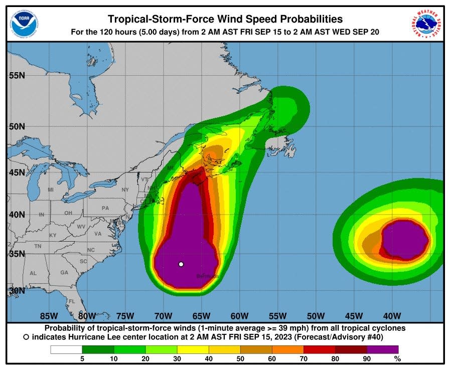
But the track of the storm could affect the wind speed on Cape Cod. According to the forecast discussion, "a small shift east or west would make a significant difference in expected wind speeds."
How much rain is expected for Cape Cod?
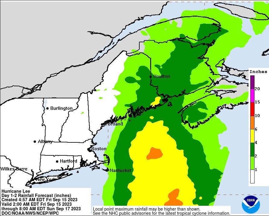
According to the National Weather Service, Cape Cod and the Islands may see two to four inches of rain from the storm. Other parts of eastern Massachusetts may see one to two inches of rain. Dry weather is expected from Rhode Island to points west.
How to prepare for the storm
The National Oceanic and Atmospheric Administration suggests that folks have "enough non-perishable food, water and medicine to last each person in your family a minimum of 3 days (store a longer than 3-day supply of water, if possible)." Because of possible power outages, it's a good idea to keep extra cash on hand and have a good supply of battery-powered flashlights and a radio. For cellphones, a solar or portable crank charger could be very handy.
More: Flashlight, batteries, nonperishables: On Cape Cod, how to prepare for possible hurricane
What is the weather forecast for Cape Cod?
Here is the Hyannis forecast from the National Weather Service:
Friday: Mostly cloudy, with a high near 69. Breezy, with a north wind 16 to 21 mph.
Friday night: Tropical storm conditions possible. Showers, mainly after 1 a.m. The rain could be heavy at times. Low around 59. Chance of precipitation is 80%. New precipitation amounts between a quarter and half of an inch possible.
Saturday: Showers, mainly before 11 a.m. The rain could be heavy at times. High near 70. Windy, with a northwest wind 26 to 34 mph, with gusts as high as 50 mph. Chance of precipitation is 80%. New precipitation amounts between a quarter and half of an inch possible.
Saturday night: A chance of showers, mainly before 9 p.m. Mostly cloudy during the early evening, then gradual clearing, with a low around 61. Breezy, with a west wind 11 to 20 mph. Chance of precipitation is 30%. New precipitation amounts of less than a tenth of an inch possible.
Sunday: Sunny, with a high near 77. Southwest wind around 10 mph.
Power outage updates and how to report or check on power outages on Cape Cod
The Eversource Outage Map is a good resource to check on power outages on Cape Cod. There is also a box in the upper left corner of the map that allows you to report or check on specific power outages.
Cape Cod ferry updates and cancellations
Hy-Line Cruises has announced that all service between Hyannis/ Martha's Vineyard and direct inter-island service between Martha's Vineyard and Nantucket has been canceled for Friday and Saturday. Hyannis to Nantucket service will run on a trip by trip basis on Friday, but service interruptions are anticipated.
Here's the latest ferry information from the Steamship Authority:
The Steamship Authority is waiving change and cancellation fees for travel booked for Friday, Saturday, or Sunday.
Nantucket route on Friday: The M/V Iyanough is expected to make the first two round trips of the day. After the vessel returns to Hyannis at 1:30 p.m., all high-speed service for the rest of the day will be on a trip-by-trip basis.
The M/V Gay Head will make its last trip of the day leaving Nantucket at 1:30 p.m. This trip, which is for hazardous commodities only, will unload in Woods Hole, then the vessel will continue on to our Fairhaven maintenance facility and berth until the storm passes.
The last trip of the M/V Woods Hole from Nantucket will be at 2:45 p.m., arriving in Hyannis at 5 p.m. The Steamship Authority expects the last trip of the M/V Eagle to be the 5:30 p.m. departure, arriving in Hyannis at 7:45 p.m. We expect both vessels to end service for the day at that point.
Nantucket route on Saturday: The Steamship Authority expects the M/V Iyanough will not run on Saturday. The earliest the Steamship Authority expects service to resume is the 5:30 p.m. departure from Hyannis on the M/V Woods Hole or the 8 p.m. departure from Hyannis on the M/V Eagle.
Martha's Vineyard route on Friday: Service interruptions are not expected, but travelers taking trips later in the evening should monitor the Steamship Authority website for cancellations.
Martha's Vineyard route on Saturday: All service will be on a trip-by-trip basis.
Flight delays at Logan Airport in Boston and T.F. Green in Providence
As of Friday morning, both major airports are showing limited delays and cancellations for Friday night and Saturday morning flights. Cape Air has canceled its 4:50 p.m. Friday and 6 p.m. Friday flights from Logan to Bar Harbor, Maine.
The message on Logan’s website says “Due to expected weather conditions, passengers are advised to check with their airline on the status of their flight before coming to the airport: https://loom.ly/OZ0LePU”
Cape Cod National Seashore closures and cancellations
Due to the storm, the Cape Cod National Seashore will close the Marconi Beach stairs in Wellfleet and the walkways to Nauset Light Beach in Eastham and Head of the Meadow Beach in Truro at 5 p.m. on Friday. The Oversand Route will also be closed on Friday at 5 p.m. All beach fire permits for Saturday have been canceled.
The Dark Sky Festival slated for Friday and Saturday has been canceled, including the Star Party on Friday evening. Saturday's outdoor ranger programs have been canceled, but indoor programs will still take place.
According to a Seashore release, "other beach access points or areas of the park may be closed at any time due to hazardous conditions."
More: Hurricane Lee cancellations: What to look out for
How to watch the storm on Cape Cod webcams
Stay safe and watch the storm from the comfort of your home. Here are Cape Cod webcams that will give you a good idea of what Hurricane Lee is bringing to our region:
Hyannis: Anchor Inn Hyannis Harbor Live Cam
Dennis: Horsefoot Cove on the Bass River
Orleans: Skaket Beach and Nauset Beach
Provincetown: Harbormaster’s Lookout and Pilgrim Monument
Wellfleet: Beachcomber at Cahoon Hollow
Woods Hole: Woods Hole Inn and Eel Pond
Orleans prepares for storm
In Orleans, the first call for a tree branch in wires came shortly past 1 p.m. Friday. Fire Chief Geof Deering estimated the town was already experiencing gusts of 25 to 30 mph.
He said the town was expecting "a fair amount of high winds," and officials are concerned about surf and erosion -- especially at Nauset Beach and Skaket Beach — as well as the potential for coastal flooding. Worries were also high about the potential for power outages, always a particular concern, Deering said, because Orleans "has a vulnerable population. Many are elderly or seniors." — Heather McCarron, Cape Cod Times
This article originally appeared on Cape Cod Times: Hurricane Lee track nears Cape Cod: high winds, coastal flooding

