'Likely downed trees and potential power outages' Hurricane Lee nearing South Shore
This story will be updated throughout the day today.
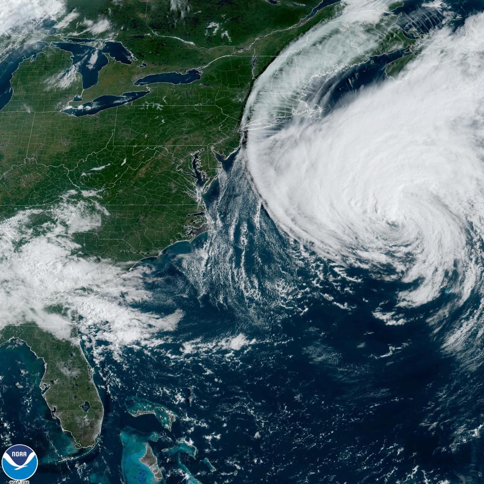
The northeastern trek of Hurricane Lee is edging ever closer to the South Shore, with heavy rains and winds on track to begin late tonight before peaking overnight and into Saturday morning.
To see the latest SATURDAY storm coverage, click here.
"Tropical storm conditions are expected to begin in southern New England within the next few hours," the National Hurricane Center said in its 8 p.m. update Friday, Sept. 15. "These conditions are likely to lead to downed trees and potential power outages."
While Cape Cod is predicted to see the biggest effects of the storm in Eastern Massachusetts, wind and ocean surges could spell trouble for the South Shore. Estimated wind speeds of 50-60 mph and 1-3-foot ocean surges could spell trouble, particularly for the South Shore's coastal communities.
More: National Hurricane Center tracking tropical depression expected to become hurricane soon
On the South Shore, low tide on Friday evening was at 6:30 p.m. at Brant Rock. On Saturday, the high tides are at 12:44 a.m. and 1:02 p.m., whereas the low tides are at 6:51 a.m. and 7:07 p.m.
National Grid and Eversource have been preparing to respond to any outages, and a fleet of utility vehicles from New York were parked in a lot in Pembroke Friday morning.
More: National Hurricane Center tracking Hurricanes Lee, Margot. See who could be impacted
Flight delays at Logan Airport in Boston and T.F. Green in Providence
As of Friday, the Logan and T.F. Green airports were showing limited delays and cancellations tonight and Saturday morning.
“Due to expected weather conditions, passengers are advised to check with their airline on the status of their flight before coming to the airport," The message on Logan’s website says.
Latest Friday storm updates
Gov. Maura Healey declared a State of Emergency in Massachusetts on Friday and is requesting that FEMA issue a pre-disaster emergency declaration, she made the announcement during a noon press conference. A state of emergency and an emergency declaration makes Massachusetts eligible for direct federal assistance for response costs, personnel, equipment, supplies and evacuation assistance.
Healey activated 50 National Guard troops for storm preparation and to be prepared to respond with high-water vehicles if needed.
The Massachusetts Department of Transportation is telling residents to plan ahead and to stay off the roads in the height of the storm.
The MBTA Hingham/Hull Ferry: All inbound and outbound trips will be cancelled following the conclusion of the outbound 8:25 PM trip from Long Wharf (North) to Hull and Hingham. On Saturday, September 16, all MBTA ferry services will be cancelled. On Sunday, Sept 17, all MBTA ferry services will operate their normal schedules.
"Hurricane Lee has been moving faster now than it has all week long. It is moving away from Bermuda as a Category 1 hurricane and through Friday night, it is going to maintain that strength," said meteorologist Cindy Fitzgibbon from WCVB, a media partner of The Patriot Ledger. "Tropical storm force sustained winds are possible on parts of the outer Cape, where we could see gusts 50 to 60 miles per hour."
And because Plymouth is so close to the Cape, it could get some big gusts, too. Wind gusts in Plymouth could be as high as 44 mph, the National Weather Service says. And Saturday, in addition to rain, the gusts are predicted to be as high as 47 mph. Quincy's forecast isn't much different with the highest wind gusts predicted at 43 mph.
Rain forecast is 1 to 4 inches in Eastern Massachusetts.
Forecast for Saturday night from the National Weather Service for Quincy: A slight chance of showers before 10 p.m. Mostly cloudy, then gradually becoming clear, with a low around 58. Breezy, with a west wind 17 to 22 mph decreasing to 11 to 16 mph after midnight. Chance of precipitation is 20%.
Forecast for Sunday from the National Weather Service for Quincy: Sunny, with a high near 79. West wind 8 to 10 mph.
Hurricane Lee projected path tracker
This forecast track shows the most likely path of the center of the storm but does not illustrate the full width of the storm or its impacts. The center of the storm is likely to travel outside the cone up to 33% of the time.
Where Lee is supposed to strike and when: The latest
The latest National Hurricane Center projections show Lee is expected to travel north and make landfall at Nova Scotia, Canada, late Saturday.
On its way tonight and through most of Saturday, it is expected to bring heavy rains, strong winds, flooding and storm surges to the South Shore.
More: Is the power out in Norfolk County, Massachusetts? Check here.
How big is Hurricane Lee?
Lee had a diameter of tropical storm force winds or higher across 564 miles early this morning, with winds of hurricane force spanning 184 miles. The tropical wind field is larger than the equivalent of 15 Rhode Islands if you measure from the state from east to west, and larger than 3 Massachusetts - again measuring east to west.
How is the size of a hurricane measured?
It's easy to roughly guesstimate the size of a hurricane using forecasts and satellites, but experts use a more exact method to calculate the size of the wind fields within the storm.
The size of the wind field in each quadrant of the storm is spelled out in each of the hurricane center's forecast advisories.
Wind fields are fluid and can shift and move depending on what's happening within the storm and how close it is to land, where there's greater friction than over the water.
"It's complicated," said Daniel Chavas, an associate professor of atmospheric science at Purdue University who has spent much of his career so far working on wind size. "It's so complicated, that there's no defined list" of hurricanes by size, Chavas said.
The National Oceanic and Atmospheric Administration has easily accessible lists that compare hurricanes by wind speeds and barometric pressure, but not size.
Here are some tips to prepare for the storm, and what to do after.
Set up alerts and follow trusted sources
Are you signed up for your town’s alerts? Patriot Ledger alerts? Download our app – iOS or Android – and turn on the alerts. Do you know where to find the latest information from the National Weather Service? If not, now is the time to take notes.
Visit your municipality’s website to sign up for alerts and find information to stay informed. The National Weather Service can be found on social media or on their website. The local Boston office is weather.gov/box. The Massachusetts Emergency Management Agency is also a source for information about severe weather, which can also be found on social media.
Webcams: Watch weather livestreams on the South Shore, Cape Cod
More: Live storm tracker
Know your zone
Do you know if you live in an area that could be asked to evacuate? Certain parts of Massachusetts are within hurricane evacuation zones. Zones A and B cover most coastal areas as well as those near rivers. Zone C is designated for Boston and Cambridge.
You can find out if you’re in an evacuation zone by visiting the official Commonwealth of Massachusetts website.
A look back at 8 storms: What are the biggest hurricanes to hit Massachusetts?
More: Monitor power outages in Plymouth County, Massachusetts
Make an emergency kit and plan
An emergency kit should include the essentials for you and your family – and don’t forget any pets, too. Emergency officials suggest making a kit to last up to three days.
Think about putting together a kit that contains the following, which includes but is not limited to:
Bottled water, one gallon per person per day for at least three days
A three-day supply of non-perishable foods that don’t require cooking or heating. Be sure to pack special foods for those with particular diets
Supplies, such as a manual can opener, utensils, radio, flashlight, watch or clock, charged cell phone battery pack, pliers, wrench, first-aid kit, local maps, duct tape. There might be other tools that are useful to you. Keep in mind items that you can use without a power source.
Personal items like medicine, personal hygiene, glasses, contact lenses, dentures, clothing, substantial shoes, necessary medical equipment, baby items, blankets, sleeping bags, books or games.
Pet items like food, bowls, collar or harness, leash, crate photos and medical information.
Important documents like insurance policies, ID cards, bank records and medical information. Be sure to take photos and videos of the interior and exterior of your home before the storm’s arrival for insurance purposes.
Money
Also, make a plan for your family that includes emergency contacts and meeting locations.
More: What watches and warnings are in effect right now in Massachusetts?
Put together a power outage plan
Extensive summer rains have South Shore officials concerned, as strong winds from Hurricane Lee could more easily topple trees and power lines in the saturated ground.
If the lights are out for an extended period of time, what will set you up to be most comfortable?
Emergency management officials say to fully charge your electronic devices like your laptop and cell phone; keep your car’s gas tank full; and temporarily set your refrigerator and freezer to the coldest setting. If your water supply can be impacted by a power outage, be sure to fill up a bathtub with water to flush toilets.
Additionally, check the batteries on your smoke and carbon monoxide detectors and consider a generator, if you don’t already have one. Remember: only operate a generator outside the home and point the exhaust away from the house.
Get your home ready
Take inside or secure anything that could become a projectile or be swept away in a flood. This can include patio furniture, toys, grills, lawn mowers, trash cans or even storm prep debris like rotten branches (if those have yet to be picked up before the storm).
Consider also protecting your windows or glass doors with storm shutters or temporary plywood. After the storm, be sure to take them down as boarded up windows become a safety hazard.
Despite what you may have seen, taping your windows can be more harmful than not, as it doesn’t protect windows and can create large, dangerous shards of glass. So, don’t bother.
If you have a basement, be sure to elevate items to reduce the change of flood damage.
What about your boat?
Boat owners have been busy at the docks bringing their vessels on dry land ahead of the storm. The U.S. Coast Guard is advising boat owners to make sure their watercraft are secured or moved to a safer location.
“Double-check mooring lines, anchorages and dock cleats to prevent damage or loss of boats,” the Coast Guard said. Also, don’t go out to sea to ride out the storm.
Emergency numbers to know
To report a downed power line, medical, fire, or other emergencies, dial 911.
Eversource: 800-592-2000
National Grid: 800-465-1212
Verizon: 800-VERIZON
Comcast: 800-XFINITY
What to do during and after the storm
You should remain indoors and try not to go out or drive. If you are driving and you see a flooded road, it’s best to “turn around, don’t drown,” emergency officials say. Avoid the water and keep off of beaches.
An evacuation may be necessary at a moment’s notice, so prepare to take the essentials with you.
After the storm, assume that any downed power line is live. Report wires, gas leaks or other emergencies by calling 911. If your power is out, make sure your electric utility knows. Continue to monitor official updates.
Hannah Morse covers growth and development for The Patriot Ledger. Contact her at hmorse@patriotledger.com. David R. Smith covers trending and breaking news for The Patriot Ledger. Contact him at drsmith@patriotledger.com.
This article originally appeared on The Patriot Ledger: FRIDAY RECAP: Hurricane Lee to affect Quincy and South Shore

