'A gateway to the city:' Mount Dora council rezones Highland St. property, paving way for development
MOUNT DORA — The Mount Dora City Council approved a rezoning request for a nine-acre property on Highland Street, paving the way for future development.
Six council members and Mayor Chrissy Stile voted to approve the ordinance on Tuesday after deliberations at two meetings. Council member Austin Guenther abstained from voting due to a potential conflict of interest.
The application to the city requested to rezone the acreage from a Workplace or WP-1 area to a Mixed Use Traditional or MU-1 zoning designation.
The dilemma for the property owners was that, although the city’s Future Land Use Map labels the land as MU-1, the zoning remained at WP-1.
Without the city’s approval for the zoning change, the property could not be developed because the map and the zoning were in conflict.
In general, the MU-1 zoning category allows for a combination of land uses that may be public, civic, commercial, office, multi-family residential, and limited single-family use as an adjunct to a business use. Whereas the WP1 designation focuses on manufacturing and employment.
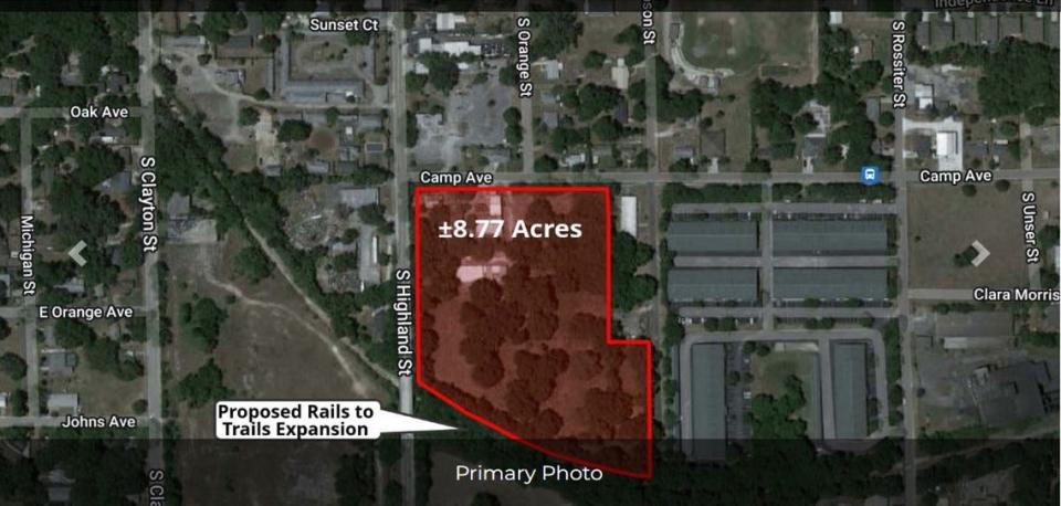
The site lies on the southeast corner of Highland Street at the corners of Camp Avenue to its north and Robie Avenue to the south. Highland Street is an entranceway into Mount Dora from U.S. Highway 441 on the south and from State Route 46 and 1st Avenue from the east.
In other Mount Dora news: Mount Dora preservation board begins review of options to prevent 'demolition by neglect'
Dine: Eden Abbey Brewing Community hosts grand opening in Mount Dora
More: Lake Sheriff's Office body cam footage shows Mount Dora car chase, shootout with police
Staff and zoning committee recommended the change
Vince Sandersfeld, director of the city’s Planning and Development Department, reported to council members that the Planning and Zoning Commission voted to recommend that the council approve the change.
“This request is for the MU-1zoning to be consistent with the underlying Future Land Use designation,” said Sandersfeld during the first reading of the ordinance earlier in July. “The applicant currently does not have a development plan for the property and is only seeking to rezone the property so that the zoning district matches the land use category.”
The city’s attorney Sherry Sutphen reminded the council that “the code does not require a site plan when they (the applicant) come forward to ask for zoning change.”
A developer’s application for any proposed construction on the site would undergo multi-stages of review, including examination by the city’s Development Review Committee as well as the planning commission. Eventually the plat – a map that details the use of the property – would come before the
council for its consideration.
A city’s comp plan defines desired and permissible development. The FLU map had been approved as part of the most recent City of Mount Dora Comprehensive Plan 2045 which was updated just over two years ago.
In referring to the 2010 plan and its update in 2020, Sandersfeld explained that this block “was anticipated to be more of a gateway to the city with intense uses.”
“The city has developed high standards for the Mixed Use. It’s a voluminous zoning district,” he added.
Commonly referred to as a “comp plan” in planning and governmental circles, it is intended to guide community development and growth. State and federal governments use the plans to prioritize funding for municipalities.
Florida Statutes detail the required and optional elements in a comp plan as well as describe the process for a government to adopt or amend a comp plan, including public input. The state mandates that it must include at least two planning periods, one covering at least a five-year period after adoption and
one including at least a 10-year period.
In the city’s plan, Highland Street is specifically cited as a corridor with a mix of residential, neighborhood commercial, light industry and warehouse uses.
“Although redevelopment has been actively pursued in this area, there are still vacant and underutilized sites along the street frontage,” notes the plan.
Mayor initially questioned suitability of the rezone
While ultimately voting to advance and approve the ordinance, the mayor voiced concerns for the rezone.
“Without seeing a plan that comes with this rezoning, we’re transitioning from a workplace district which does not include up to five-story buildings that are high-density residential,” said Stile when addressing council members in early July. “And we’re talking about rezoning to a mixed-use district which does include five-story, high-density residential building on Highland.”
“Do we want it to be apartment buildings that are five stories high up and down Highland with traffic, and everything else that comes along with all these other developments we vote on at every single meeting at this point, that seem to irritate more of the city than it helps?” she posed to the council.
“But the problem is that the land use, the vision and the policies are already adopted,” explained Sandersfeld. “So, to reject the rezoning because its inconsistent with the vision that we haven’t discussed and changed, we start to bounce onto some property owner rights issues because they already have an adopted land use.”
“Long-term crystal ball, we would have to go back and have charettes and other studies of land use change,” he advised about making any changes to the map. “And bring together all the stakeholders in the city in - and everybody back in - about what type of revisioning or retooling of that land use plan.”
Property is listed on the market
Owned by Daniel and Judith McWhorter of Eustis, the rezoning application was submitted on their behalf by Timothy Green of Green Consulting Inc. based in Mount Dora. According to the deed, the couple has owned the property since 1978.
In his comments to the council in early July, Green noted that the requested change is “purely for marketing.”
“It is under contract but hasn’t been purchased,” he said. “Due diligence of any property transfer is ‘What can I build on it?’”
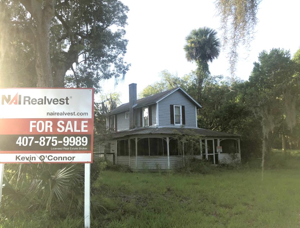
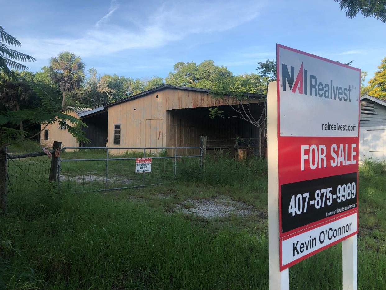
The 8.77-acre property is for sale at $3.3 million through the listing agent Kevin O’Connor of NAI Realvest, the Orlando-area representative of NAI Global.
According to the company’s website, Realvest has been in Florida commercial real estate since 1988.
Marketed as future land use with MU-1 zoning, the listing on the company’s website describes the parcel as an outstanding location for multifamily or high-end townhomes.
Currently on the site is a three bedroom, 1-1/2 bath home with detached garage, unfinished utility
buildings and pole sheds/carports.
Sandersfeld clarified to council members that the site is not within the historic district.
This article originally appeared on Daily Commercial: Mount Dora rezones area near Highway 441 for Mixed Use, development

