Global pattern in turmoil; Flip to El Niño triggers come-and-go summer
La Niña was the dominant driver of our seasonal weather patterns for the past three years, but the global pattern is now in a state of turmoil as a new driver is in town.
El Niño conditions are now in place, and it appears we are quickly heading into a rather strong El Niño event.
However, even as the atmosphere and the Pacific Ocean complete the rapid pattern reversal, we are still feeling lingering effects from the exceptionally long lasting La Niña event. So, what does that mean for the upcoming summer season?
Our summer forecast for late June, July, and August calls for a "come-and-go" summer across Canada. We will continue to see periods of hot and dry weather, but the heat will be broken up by significant shots of cooler weather.
Overall, a cooler summer is expected compared to the past few summers, especially across the eastern half of Canada. However, we will still see some lingering effects from the fading La Niña pattern with periods of hot weather, especially across the western half of Canada."

This resembles the pattern that we have seen across Canada since the start of the meteorological summer, which began on June 1st (since the warmest three months of the year are June, July and August).
The temperature anomaly map below for June 4th–19th shows that for most of June thus far, temperatures have been cooler than normal across eastern and northern Canada and warmer than normal across most of western Canada.
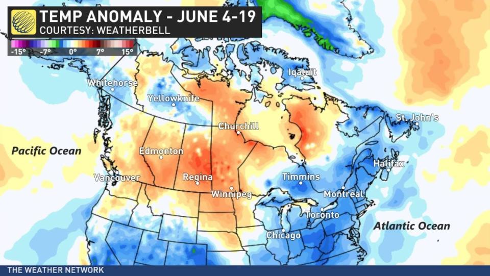
However, the temperature roller coaster has been felt across the country. Much of western Canada has been in the midst of a period of unusually chilly weather since the weekend, including a major snowstorm with road closures in the Central Rockies.
SEE ALSO: North Atlantic temperatures are breaking records. What does it mean?
Meanwhile, most of eastern Canada had a couple days of hot weather at the beginning of June, and summer weather is making a temporary comeback for the official start of summer.
Drought, wildfires, and wildfire smoke will continue to be of major concern for many areas through the summer.
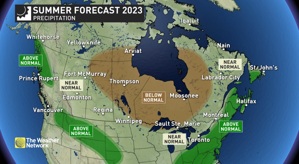
Canada's Summer Precipitation Outlook
The primary storm track will often be south of the U.S. border, but it should shift north at times and bring near-normal rainfall totals to much of southern Canada.
A more active pattern is expected in Atlantic Canada, with the potential for above-normal rain totals for much of the region. This is quite a contrast to what we saw during much of spring, with drought conditions and devastating wildfires. However, since late May, this region has been wetter.
The precipitation anomaly map for the past 30 days (see below) highlights the wetter pattern that has developed for most of Atlantic Canada. Parts of Alberta and adjacent areas have become much wetter as well (including localized flooding). Meanwhile, most of Ontario and Quebec have been very dry.
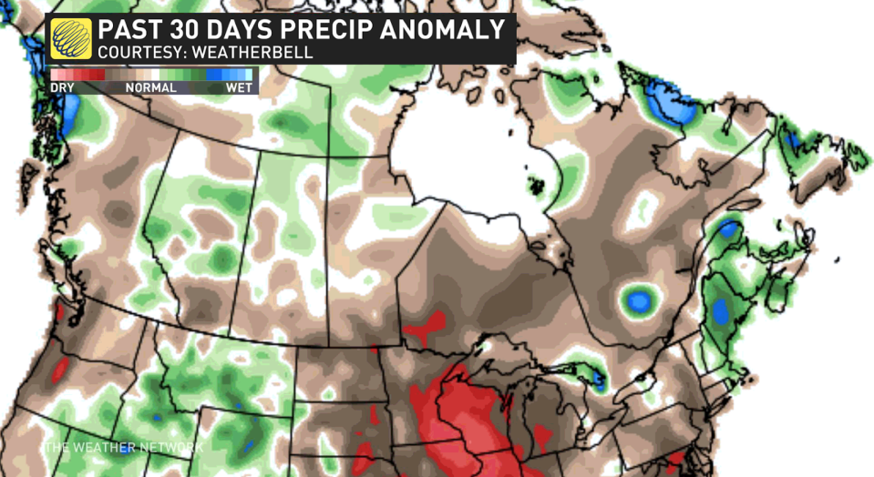
Many of the drought areas will see widespread beneficial rain during the final week of June, but with so many large fires already burning, wildfire smoke will continue to be a concern for much of the summer.

