'It's going to pack a punch': Storm expected to bring snow and wind to Cape Cod
A fast-moving storm is expected to hit Cape Cod on Tuesday, bringing snow, high winds and possible coastal flooding to the area.
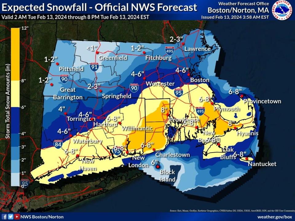
"It's going to pack a punch," said Alan Dunham, meteorologist at the National Weather Service Boston/Norton office.
The National Weather Service has issued a Winter Storm Watch, in effect from late Monday night through late Tuesday night. Dunham said precipitation on Cape Cod was expected to begin as rain or a rain/snow mix between 3 to 5 a.m. on Tuesday, with a changeover to heavy wet snow by around 8 a.m.
The heaviest snowfall on the Cape is expected to occur between about 10 a.m. to 5 p.m., according to Dunham, when snowfall rates could reach one to two inches per hour. Total snowfall amounts of around eight inches are possible on Cape Cod.
The National Weather Service has also issued a High Wind Warning for the Cape and Islands, in effect from 7 a.m. to 10 p.m. on Tuesday. North winds from 25 to 35 mph are expected, with gusts up to 60 mph. The strongest winds are expected to occur between 1 p.m. and 7 p.m. Tree and power line damage is possible, as well as power outages, according to the National Weather Service.
A Coastal Flood Warning is in effect from noon to 5 p.m. on Tuesday for the Cape and Islands. According to the National Weather Service, "two to three feet of inundation above ground level (is) expected in low-lying areas near shorelines and tidal waterways." Minor to moderate erosion is also possible on the Cape and Islands.
Storm flooding on Cape Cod 'Extremely challenging.' Cape officials look to curb storm surge floods on low-lying roads
Hyannis forecast from the National Weather Service:
Tuesday: Snow, possibly mixed with rain, becoming all snow after 1 p.m. The snow could be heavy at times. High near 37. Breezy, with a north wind 11 to 16 mph increasing to 20 to 25 mph in the afternoon. Winds could gust as high as 47 mph. Chance of precipitation is 100%. Total daytime snow accumulation of 5 to 9 inches possible.
Tuesday night: Snow likely, mainly before 7 p.m. Cloudy during the early evening, then gradual clearing, with a low around 26. Blustery, with a northwest wind 17 to 22 mph decreasing to 10 to 15 mph after midnight. Winds could gust as high as 41 mph. Chance of precipitation is 60%. New snow accumulation of 1 to 2 inches possible.
Wednesday: Mostly sunny, with a high near 33. Northwest wind 10 to 17 mph, with gusts as high as 30 mph.
Wednesday night: Mostly clear, with a low around 23. Northwest wind 16 to 18 mph, with gusts as high as 32 mph.
Thursday: Sunny, with a high near 37. Northwest wind 8 to 15 mph.
Eric Williams, when not solving Curious Cape Cod mysteries, writes about a variety of ways to enjoy the Cape, the weather, wildlife and other subjects. Contact him at ewilliams@capecodonline.com. Follow him on X: @capecast.
Thanks to our subscribers, who help make this coverage possible. If you are not a subscriber, please consider supporting quality local journalism with a Cape Cod Times subscription. Here are our subscription plans.
This article originally appeared on Cape Cod Times: Cape Cod storm weather forecast: Snow, wind and flooding possible

