Good news, bad news for US travel and white Christmas hopes

- Oops!Something went wrong.Please try again later.
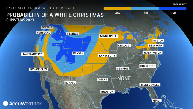
While bare ground in parts of the interior West and High Plains will be covered by snow in time for Christmas, the already lean amount of snow in the Midwest and Northeast will dwindle in the days ahead, dashing the hopes of a white Christmas for the young and the young at heart.
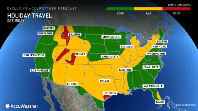
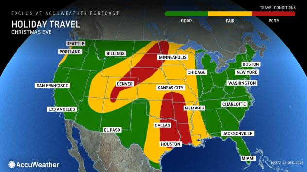
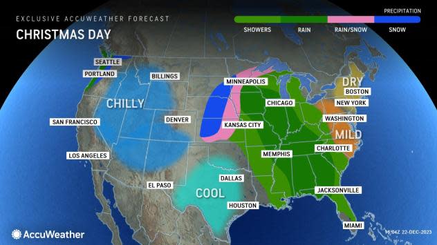
A large storm will lead to adverse travel conditions from snow and rain over the middle of the United States as Christmas travel ramps up, AccuWeather meteorologists warn.
 |
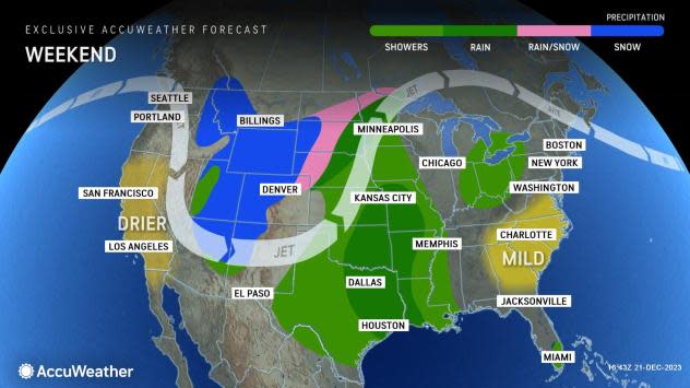
The same storm that brought flooding rainfall to Southern California earlier this week is expected to join up with another storm from the Northwest, producing widespread snow in the Rockies this weekend.
The result will be a massive storm that will affect close to 1 million square miles of the nation's midsection with about a 50/50 split between snow over the interior West and High Plains and rain over much of the Mississippi Valley spanning the extended holiday weekend.
 |
As temperatures drop over the Rockies and northern High Plains, it will allow the storm to become an efficient snow producer. Motorists should expect wintry travel to continue to spread through Saturday night along hundreds of miles of highways from northern New Mexico to the Dakotas, involving interstates 25, 70 and 80 before expanding to portions of interstates 90 and 94. Patches of slippery travel are also likely over the high ground along Interstate 40 in New Mexico and Arizona early this weekend.
AccuWeather meteorologists urge motorists who will be traveling through the Interstate 25 corridor to make sure their vehicle is winter-ready with adequate tires and warm gear on hand in case of stoppages.
 |
Denver is the primary airport that may be adversely affected by the snowstorm from Saturday night to Sunday night, with delays and possible flight cancellations.
Farther to the east, the storm's main legacy will be drenching rain, areas of fog and even some thunder and lightning in a large part of the Mississippi Valley early this weekend before expanding to much of the Great Lakes region and part of the Appalachians later Christmas Day to Tuesday.
Weather-related travel delays could mount across part of Texas on Christmas Eve, including in Houston and Dallas.
Motorists along portions of the interstates 29, 35 and 55 corridors that stretch north/south, as well as the many east/west highways that bisect these interstates over the Mississippi Valley, will encounter slick roads, poor visibility and localized incidents of ponding at some point during the extended holiday weekend.
 |
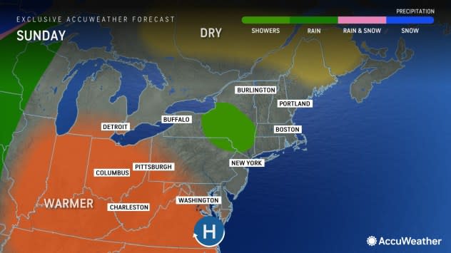
Meanwhile, in much of the eastern third of the nation, dry travel conditions are in store through much of Christmas Day.
However, the exception will be over part of the interior Northeast, as a batch of moisture will develop over the Great Lakes and extend into parts of Ohio, upstate New York and Pennsylvania through Sunday. Most of that precipitation is likely to be in the form of rain or perhaps a wet snow and rain mix. No major travel problems are expected from this activity, except perhaps over portions of central and northern New York, where a small slushy accumulation cannot be ruled out.
 |
Mr. Heat Miser and Mr. Snow Miser, animated characters from the 1974 Christmas special, The Year Without a Santa Claus, will battle it out in the coming days over the U.S.
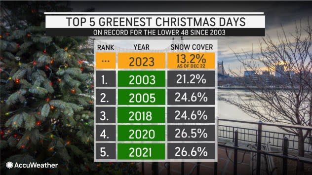
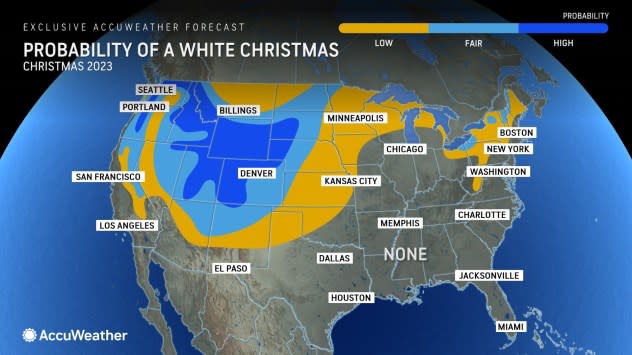
Factoring in rising temperatures from the Mississippi Valley to the Northeast and the expansion of snow over the interior West, much of the population of the lower 48 states is unlikely to have a white Christmas this year.
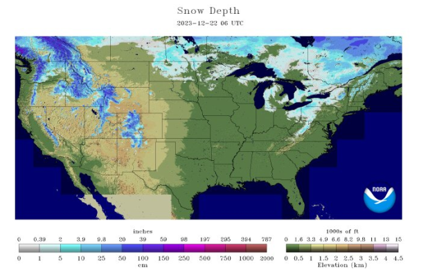
As of Friday, just 13.2% of the contiguous U.S. was covered with snow, with the country on pace for a record low by Dec. 25, according to the National Weather Service.
 |
This year could go down as one of or perhaps the least white Christmases on record.
In portions of the interior Northeast, where there is still some hope, that chance is based on the survival of existing snow cover from snow showers early this week. That snow will continue to melt each day into Christmas.
In portions of the southern High Plains to the Upper Midwest, there is a chance that the tail end of the big storm may bring a sweep of cold air that catches up with lingering moisture to allow a little snow on Christmas Day. However, that is a stretch, and the odds of this occurring from the Texas Panhandle to northern Michigan are slim. The best chance of this occurring will be from central and eastern Kansas to eastern Nebraska and far northwestern Missouri.
 |
This map shows the amount of snow on the ground across the lower 48 United States as of Dec. 22, 2023. (National Weather Service) |
"Duluth, Minnesota, which has a 92% historical average chance of a white Christmas, had only 1 inch of snow on the ground at the airport on Wednesday, which it is forecast to lose this week," AccuWeather Meteorologist Jesse Ferrell said. "Duluth is not forecast to have any snow on the ground on the morning of Dec. 25, 2023, joining 2006 and 1979 as the only other 'Green Christmases' in the station's 70-year history."
 |
The best bet to see natural snow on the ground for Christmas morning will be over the Intermountain West from the peaks of the Sierra Nevada and the higher elevations of the Cascades to the Rockies and adjacent High Plains.
Want next-level safety, ad-free? Unlock advanced, hyperlocal severe weather alerts when you subscribe to Premium+ on the AccuWeather app. AccuWeather Alerts™ are prompted by our expert meteorologists who monitor and analyze dangerous weather risks 24/7 to keep you and your family safer.
