Google’s ‘dynamic world’ map tracks humanity’s destruction of nature in real-time
A new tool from Google allows you to track the Earth’s surface in near real-time - and how humans have shaped the face of the planet.
Dynamic World, launched on Thursday, colour-codes land into categories like “water”, “crops” and “built”. Users can enter a time - from June 2015 up to two days before the present moment - to see what comprised the landscape, according to a company statement.
Most interestingly, users can follow how landscapes change in response to seasons or disasters like wildfires — essentially letting you see how the human-caused climate crisis is impacting the planet.
“If the world is to produce what is needed from land, protect the nature that remains and restore some of what has been lost, we need trusted, near real-time monitoring of every hectare of the planet,” wrote Craig Hanson from the non-profit, World Resources Institute, who developed the tool with Google.
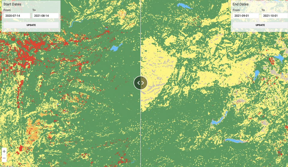
The Dynamic World page has examples of events with pretty obvious land-cover changes. When you click on the example of the Caldor Fire, which swept through northern California last year, the tool zooms into an area just south of Lake Tahoe — with pre-blaze land on the left and post-blaze land on the right.
Moving the slider back and forth, users can see how a massive swath of the Sierra Nevada mountains went from tree cover to “shrub and scrub”, detailing the wreckage of burnt land the flames left in their wake.
Other examples are more interesting than depressing — a comparison in Botswana’s Okavango Delta shows how the region fills up with greenery during the seasonal floods. Users can zoom into any location and select any date range to see how the landscape has changed.
The data comes from satellites and is analysed quickly to provide rapid updates, Google says.
The climate crisis is causing major changes to natural and built environments. Disasters like wildfires, hurricanes, droughts and sea level rise are altering the landscape in profound ways, turning coastal marshes into oceans, cropland into desert and towns into disaster zones.
“With this information, people — like scientists and policymakers — can monitor and understand land and ecosystems so they can make more accurate predictions and effective plans to protect our planet in the future,” Google says.

