Google Maps travel tips to navigate and learn about places you visit (even without Wi-Fi)
"Easy Travel” is a ten-part series focusing on how to reduce bumps during vacations, anticipate roadblocks and be ready when things aren’t going your way. If you'd like to contribute to our future reporting and share your experience as a source, you can click here to fill out this quick form.
It goes without saying, but gone are the days of paper maps for navigating. We mostly all have phones in our pockets that can show us where to go, which comes in especially handy when traveling to a new place, even when reception isn’t guaranteed.
USA TODAY Travel reporters Zach Wichter and Kathleen Wong teamed up to share some of their favorite digital map tips to help travelers on their journeys.
Street navigation and offline map access
Zach: I’m a little map-obsessed myself. The post below on X, formerly Twitter, really speaks to me. So, before I visit a new place, I typically spend hours looking around on Google Maps to familiarize myself with the geography.
sorry I'm late i was zoomed in on google maps following a really long river from source to mouth
— belle of the balls (@rufuscesspool) December 17, 2022
It’s not just natural features I’m interested in, either. Google Maps comes in super handy for learning the basics of a new city’s transit system and other ways to get around. Especially if I’m arriving after an overnight flight, I like to know exactly how I will get to my lodging. I often take screenshots of transit directions for that first trip so I don’t have to worry about bad service or lack of airport Wi-Fi to get where I’m going.
However, I may want to start using the app directly more often.
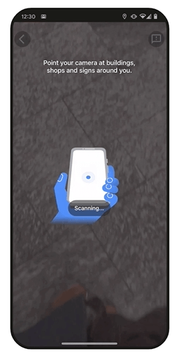
Christina Tong, a senior product manager at Google, said "Live View" directions are available everywhere that Street View imagery exists.
“It’s a really new capability that is helping you navigate in augmented reality and be able to search your surroundings,” she said. Live View allows Maps users to see turn-by-turn directions overlaid on street view. Tong said the feature can be especially helpful for orienting yourself when you come out of a subway station and need to get your bearings.” You can even use it in some indoor locations like certain shopping malls and airports for more detailed wayfinding.
Live View is accessed through the camera icon on the walking directions tab. To use it, you must have an active internet or data connection.
Tong pointed out that the Maps team is also rolling out bike and scooter directions in many cities.
“This bike and scooter information is available on Google Maps in more than 500 cities globally,” she said, adding that information about vehicle availability, dock locations and battery levels for e-bikes and scooters is also provided in the bike directions tab.
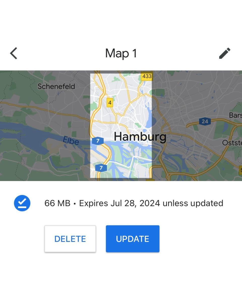
Another cool feature that’s especially helpful when using Google Maps abroad is the option to download offline maps. Doing that allows you to navigate and find some basic information about popular sites where you’re visiting, even if you don’t have cell service outside of the U.S., like when I went on a reporting trip to Hamburg this spring. or are traveling somewhere with poor reception.
“Two cases for me: I’m about to go camping or take a road trip and I’m going to be driving through a place that has less phone reception coverage, or if I’m traveling internationally and my phone doesn’t cover a data plan,” Tong said. “This was actually one of our most requested tools and I’m really excited to share that with travelers.”
To download offline maps:
Tap your profile picture or the initial icon in Google Maps
Then tap “offline maps” and choose the select your own feature
Zoom in on the area you want to save, and then hit download
Cruising Altitude: Is airplane coffee safe to drink? I'll try to put the rumors to rest.
Customizing your map for a trip, collaborating with friends
Kathleen: When I travel, I always employ Google Maps – and not just for directions. The online tool helps me easily visualize my destinations to develop an efficient game plan.
I’ll include Google Maps in my research when I check out accommodations to book. I’ll scroll around to explore neighborhoods and see what businesses are nearby. (For obvious reasons, it’s important that a good coffee shop is within walking distance of my hotel or Airbnb.)
If a business catches my eye, I’ll save it to My Maps. Usually, I’ll make My Maps for different categories, like shops or bars I want to visit, and mark them with a color or icon.
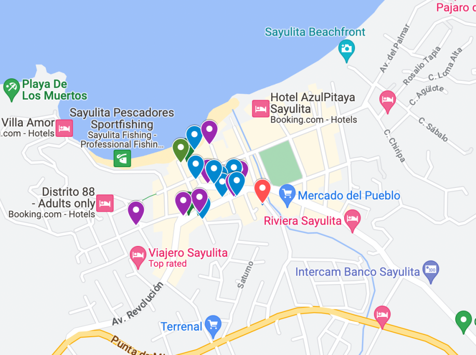
To make your layered custom map, sign into your Google Maps account and open or create a map.
Add and name a layer, like "cool bars," then explore and save certain businesses to your layer. You can even add different colors and icons to your layers.
When you’re done, hit share or preview to see your custom map.
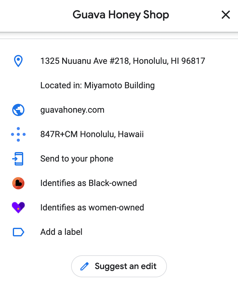
The Google Maps interface makes it easy to see the address, operating hours, contact information and if you can make reservations or order online. I’ll also do a quick look through reviews and photos. Based on how many reviews a place has, I can gauge if a place sounds popular – and will probably be busy. The digital tool also helps me support diverse businesses. You can see if a place is women-owned or LGBTQ+-owned, among other identities.
Tong also pointed out that hundreds of places are also getting added to Google Maps’ new Immersive View feature, which can help you better understand things like crowds and weather to plan your visit more precisely.
“Immersive view uses AI to fuse together billions of images and create this multidimensional view of a place,” she said.
If I’m traveling with friends, we’ll work together on marking places to visit and share the map link with each other, where all the pins live. When my New York-based friend visited me in Honolulu in 2021 for the first time, we brainstormed a map of spots that I wanted to take her to and others she wanted to visit ahead of time. We could even add notes, like saying if an eatery is a must-visit. When creating our daily itinerary, we looked at our custom map to see what was in the same vicinity so we could make the most of our time and not backtrack.
These custom maps also help me in the moment when I’m traveling. If it’s been a long day and I need to grab some dinner, I can open up Google Maps to see what spots I had previously vetted without having to frantically search for a place. Then, Maps will direct me right to the restaurant. (This is especially useful for those with dietary restrictions, so you already have a rolodex of eateries before the hanger kicks in.)
Zach Wichter is a travel reporter and columnist for USA TODAY based in New York. You can reach him at zwichter@usatoday.com. Kathleen Wong is a travel reporter for USA TODAY based in Hawaii. You can reach her at kwong@usatoday.com
This article originally appeared on USA TODAY: How Google Maps can help you navigate a new destination with ease

