Gov. Cooper warns Hurricane Ian could be deadly: ‘Today is the day to get ready.’
- Oops!Something went wrong.Please try again later.
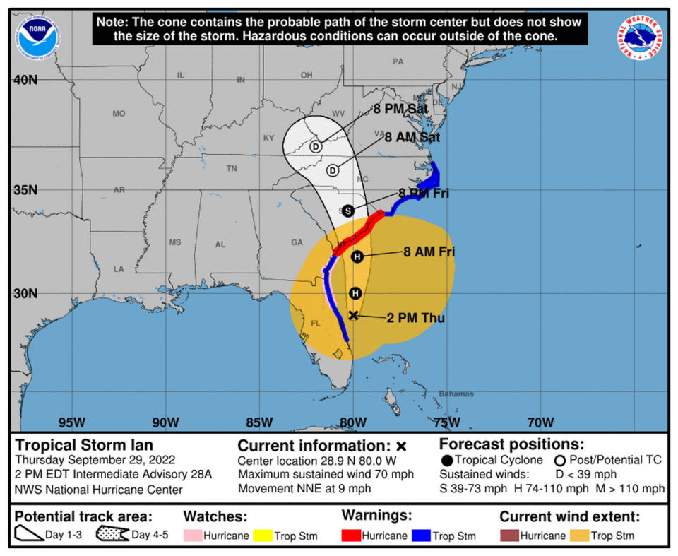
N.C. Gov. Roy Cooper urged residents to prepare for Hurricane Ian to deluge the state as it churns into North Carolina by Friday morning, calling the storm “dangerous and even deadly.”
Much of the state is under a tropical storm warning, including all Triangle counties, waiting for Ian’s expected landfall in Charleston, S.C., Thursday evening.
Cooper said search and swift-water rescue teams have been deployed statewide in advance of Ian’s arrival, particularly in the western counties where landslides are possible.
He urged state residents to prepare for power outages, which are expected but not in widespread numbers, and to check their battery and water supplies.
“Today is the day to get ready,” Cooper said at a Thursday news conference. “For North Carolinians, I want to be clear, this storm can still be dangerous, and even deadly.”
Meanwhile, all public school districts in the Triangle are canceling in-person classes Friday, when Ian is forecast to hit heaviest, though some districts will still have lessons and assignments for students to complete at home and will make Friday a work day for teachers.
Forecasters call for Ian to reach the North Carolina coast Thursday night and move west through Friday, dumping anywhere from 3 to 7 inches of rain.
The greatest threat remains flash flooding, especially Friday afternoon and into the evening, when the downpour will be heaviest.
“As we move through the rest of today and into tonight, we still have a significant time for the storm to continue to shift and evolve,” North Carolina Emergency Management Director Will Ray said around 3 p.m. on Thursday.
The fast, heavy rains could trigger landslides in the mountain counties and river flooding further east, though dry August and September months have left most rivers low enough to take storm runoff. Still, that part of the state was hit over a year ago when the remnants of Tropical Storm Fred left at least two people killed and many more missing, causing major damage to houses, roads and bridges.
Cooper offered sympathy for victims in Florida left “devastated” by Ian, and he said the storm will likely make landfall near Charleston, S.C., on its way north.
Ray said that parts of the system are expected to move through North Carolina on Saturday and into Sunday as well.
“So there will be additional rainfall and precipitation, and risk from weather through the weekend. But the bulk of the weather and the risks that we’re talking about right now from the western part of the state coast,” he said, will be Friday and Friday night.
State of Emergency in NC
Cooper declared a state of emergency Wednesday, lifting some state regulations to allow farmers to quickly clear crops and livestock out of the storm’s path. He also authorized the activation of about 80 members of the North Carolina National Guard.
North Carolina Emergency Management reported Thursday that significant flooding events are possible along the North Carolina/South Carolina border and the Charlotte area.
“We are going to see probably some continued shifts and evolution of where this storm will actually make landfall in South Carolina tomorrow,” Ray, the director, told reporters at the briefing.

Ray said that state officials are monitoring the storm so they will be able to “quickly pivot and adjust — and see if that storm does enter South Carolina, or a northern area that impacts our southeastern part of the state in a different way, or central part of the state in a different way, to be able to have those partners here, ready to move those resources around, particularly as it relates to immediate emergency sheltering — I think is going to be critical.”
N.C. Department of Transportation Secretary Eric Boyette said 1,500 chainsaws are available for cleanup and rescue, along with 11,000 barricades, 1,400 trucks and 400 backhoes.
The governor and Boyette warned against driving in water too deep to see pavement, and he encouraged NC residents to check on their neighbors. Information on storm preparation can be found at readync.gov.
Ray also shared safety tips about what to do if the power goes out, reminding North Carolinians to use generators and grills outside and away from their houses.
“Please don’t drive through roads with standing water. Turn around, don’t drown,” Boyette said.
Thursday #ncwx update:
• Ian is now a tropical storm and is forecast to move off the east coast of Florida later today, curving northward and then eventually north-northwestward towards the coast of South Carolina tomorrow. pic.twitter.com/32QMsOwFw7— NC Emergency Management (@NCEmergency) September 29, 2022
