Granville draft comprehensive plan outlines ways to grow without sprawling developments
Granville has a goal of maintaining it's unique character, and one key element of the area's draft comprehensive plan outlines ways the community can grow without sprawling developments taking away its rural landscape.
Officials with the Village of Granville and Granville Township have spent the last year working on an update to their joint comprehensive plan as Licking County prepares for Intel's $20 billion investment in New Albany.
Darryll Wolnik, the village's planning and development director, explained differences in the draft plan's future land use map that represent a "shift in thinking." Rather than using the stratified Euclidean zoning designations — named after a landmark 1926 U.S. Supreme Court case involving Euclid, Ohio — of commercial, industrial, single-family residential and other specific land uses, the draft plan calls for using a density and intensity map.
"The problem you run into with Euclidean zoning is that it puts things in a box and doesn't allow natural development patterns to propagate," Wolnik said. "Then you run into sort of these cities of modern American times where … the uses are segregated and you have to drive everywhere, nothing's close. Where if you look at our traditional cities that grew organically — Granville is a great example — your uses are all mixed."
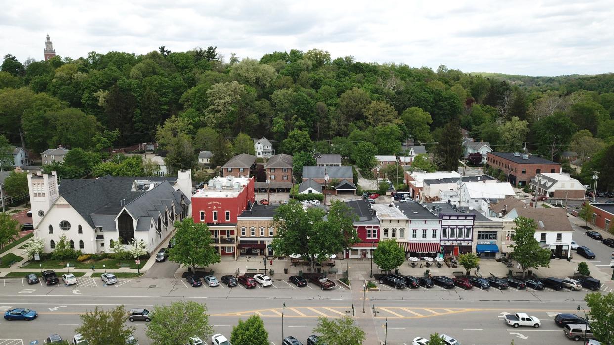
Shops, restaurants, residences, Denison University and other uses are all mixed together in the heart of Granville, he said.
"You can walk places. It grows organically, and that's what a lot of cities in the last 20-30 years are trying to get back to," Wolnik said.
Granville Township Trustee Bryn Bird said the Framework planning initiative — which is helping western Licking County communities prepare for the changes that will follow Intel — is also focusing on density and intensity maps because of the results they yield for communities.
"It's neat because what they're really saying is like, you don't want to create more subdivisions, you want to create more communities," she said.
By planning by density and intensity rather than by type, Bird said you get fewer sprawling developments where people have to get into their car to go to the grocery store or pharmacy.
Traditional zoning also doesn't allow any flexibility, Wolnik said. And that could create a problem in the future if there is a big market change, like when the COVID-19 pandemic hit and commercial office needs cratered.
"No one could have seen that coming five years ago where commercial office would just be destroyed," he said. "We need to be flexible and that's where the future (map) comes in."
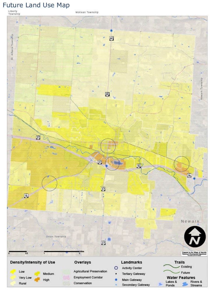
The map in the draft plan breaks down the density/intensity uses to five types:
High: Areas include the River Road and Weaver Drive corridor, along East Broadway and Prospect Street, and Cherry Valley Road north of Ohio 16.
Medium: This includes land northwest of Ohio 16/Columbus Road near Owen's Corning Tech Center.
Low: Areas include land south of Newark-Granville Road and north of Ohio 16
Very low: This includes land north of Newark-Granville Road along both sides of Jones Road.
Rural: Areas such as the southeast corner of the township along the Union Township boundary and the northern third of the township along the McKean Township line.
The higher density/intensity areas call for more non-residential uses because they are more intense, Wolnik said. He added that the village envisions the most intense uses, such as office buildings, to be along Ohio 37 and Ohio 16.
"You want folks to be able to come in and out of town easily, understanding that not everyone is going to live here. They're going to live other places," he said. "If they can get in and out quite easily, it relieves traffic on our local streets and gets them in and out fast."
He said the map is designed with the more dense and intense uses in the middle of Granville Township, near the village's center, and then the density/intensity steps down in the rural areas of township as a way to preserve those areas in the future.
"Density actually preserves rural landscapes. It's counterintuitive until you think about it, but if we follow this leapfrog and sprawl form of development, they will just eat up the natural areas," Wolnik said. "If you keep your dense and intense uses to the core, suddenly you’re preserving your rural vistas, your rural areas, you're rolling landscapes, your farmlands."
The draft land use map also indicates four "activity centers," which will be the places where Granville has the most intense activities going on, Wolnik said.
The plan states, "Myriad of business types are found in activity centers, offering everything residents and visitors alike need in one place. Activity centers are also hubs of live/work/play communities offering residents the opportunity to live in close proximity to not just their employer, but their 'third places,' or establishments in which they gather outside of the home and work."
Those include areas that are already developed such as South Main Street and East Broadway as well as Lancaster and River roads. Two activity centers focus on two areas that could see future development: Cherry Valley and Newark-Granville Roads near the Munson Springs property and Ohio 16/Columbus Road near Owen's Corning Tech Center.
The draft map also calls for implementing overlay districts in areas of the township. One such overlay would be the Employment Corridor Overlay along Ohio 16/Columbus Road. This specific overlay, which would have to be adopted separately by the Granville Township Trustees, would restricts development to non-residential projects.
"Further, while allowing commercial and industrial development, the overlay restricts the types of heavy industry that are allowed – those uses with high nuisance potential would not be permitted," according to the draft plan.
The village and township are already working to create a joint economic development district, or JEDD, along the Ohio 16 corridor. JEDDs are an economic development tool that allow townships to partner with a municipality to collect income tax on commercial properties within a defined area.
Granville Township Trustee Rob Schaadt said he is starting to explore the Employment Corridor Overlay, something he said he has been in favor of prior to becoming a trustee.
"The best thing about it, in my opinion, it allows anybody who owns land out there now, if they're happy with their current zoning, they can keep their current zoning. However, if they want to take advantage of some things within the overlay district, it makes it a very easy, streamlined process to get some additional benefits," he said.
The entire 60-page draft plan can be found on the village's website under the "Quick Links" tab, along with an implementation matrix that includes all the action items.
Village and township officials are in the process of sharing the plan with the community at local events. Two public forums are scheduled for May, with the first happening at 6 p.m. May 9 at the Granville Township Garage and then another the following week at 6 p.m. on May 16 at the Village Hall.
mdevito@gannett.com
740-607-2175
Twitter: @MariaDeVito13
This article originally appeared on Newark Advocate: Granville draft plan outlines growth without sprawling developments

