Winterlike blast to unleash heavy lake-effect snow, squalls in Upper Midwest and Northeast


A lake-effect setup brought snow along with dangerous snow squalls to several states and some well-traveled highways as far to the southeast as the mid-Atlantic region Tuesday night, and bands of heavy lake-effect snow will continue across New York state into Wednesday, AccuWeather meteorologists warn.
The same storm that produced feet of snow in the Rockies over Thanksgiving pushed across the Great Lakes on Sunday, bringing a round of snow that started off several days of wintry weather.
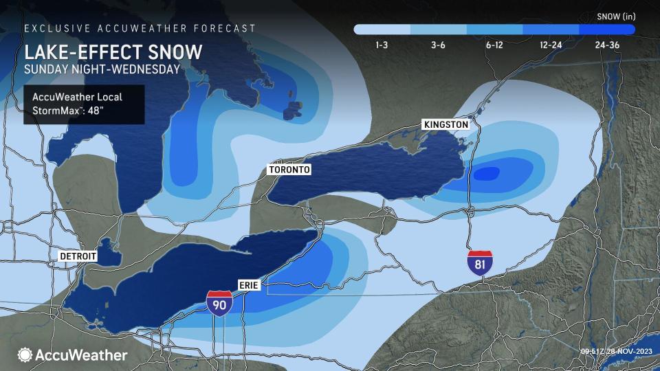
Already, over a foot of snow has fallen across a number of areas downwind of the Great Lakes. The highest total so far was 23 inches reported near Constableville, New York, which is east of Lake Ontario in the Tug Hill Plateau region.
This event, the first of the season, is expected to continue in spots through early Wednesday, allowing higher snow accumulations to pile up after several days of snowfall.
The lake-effect snow peaked on Monday night and Tuesday.
 |
While snow showers may be far-reaching, most of the heavy snow accumulation moving forward into early Wednesday is likely to stay closer to the lakes, with southern Ontario and northern New York the most likely targets for feet of snow, with 1-2 feet of snow forecast. Residents most at risk for the highest snowfall accumulations are those to the northeast of Cleveland, Ohio, around Erie, Pennsylvania, and those south of Buffalo or north of Syracuse in New York.
"Travel in the heaviest snow bands, especially in New York, could become nearly impossible as gusty winds combine with snowfall rates of a few inches per hour to create blizzardlike conditions," said Sojda.
In the western Great Lakes, the wind direction is expected to shift for Wednesday, causing the bands of intense snow to become less stationary. As such, Sojda warned that most places will be able to get a healthy dose of snow at some point.
Have the app? Unlock AccuWeather Alerts™ with Premium+
Motorists should use extreme caution while traveling through the first half of the week. Some roadways of particular concern for major accidents due to high travel speeds are Interstate 90 in western New York and northeastern Ohio and Interstate 81 from Syracuse to Watertown.
On Wednesday, as winds become more southwesterly, bands of snow may shift northward along the western end of Lake Ontario and may bring accumulating snow all the way to the St. Lawrence River.
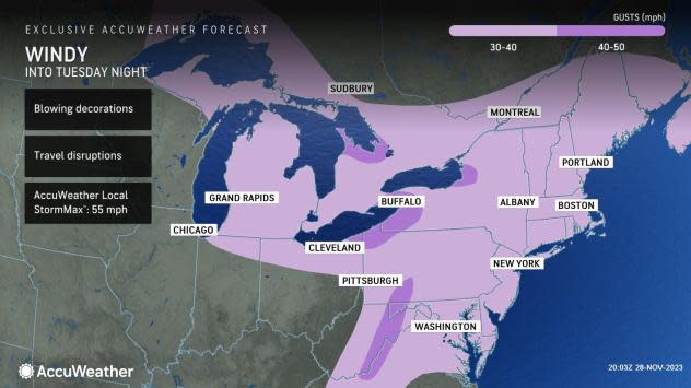
Even in areas of the Midwest and Northeast that avoid the heaviest snow, blustery winds are expected to be more widespread. Wind gusts of 30-40 mph are forecast from Michigan's Upper Peninsula to the Northeast coast.
 |
Localized power outages will be a concern, as well as localized damage. Residents should ensure any outdoor holiday decorations are secured before winds pick up.
The press of Arctic air will bring some of the lowest temperatures so far this season for the Northeast, as well as the Southeast. Much of the Great Lakes region experienced AccuWeather RealFeel® Temperatures falling into the single digits on Tuesday morning.
Shifting winds will disrupt the intensity of lake-effect snow Wednesday, but it will likely take until the arrival of enough milder air Thursday to shut down the lake-effect machine across the entire region completely.
Want next-level safety, ad-free? Unlock advanced, hyperlocal severe weather alerts when you subscribe to Premium+ on the AccuWeather app. AccuWeather Alerts™ are prompted by our expert meteorologists who monitor and analyze dangerous weather risks 24/7 to keep you and your family safer.
